Pazos District
| Pazos District | |
|---|---|
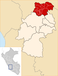
 The district of Pazos is located in the west of the province of Tayacaja (marked in red) |
|
| Basic data | |
| Country | Peru |
| region | Huancavelica |
| province | Tayacaja |
| Seat | Pazos |
| surface | 232 km² |
| Residents | 5427 (2017) |
| density | 23 inhabitants per km² |
| founding | January 31, 1951 |
| ISO 3166-2 | PE-HUV |
| politics | |
| Alcalde District | Walter Eduardo Linares Quilca (2019-2022) |
| Political party | Movimiento Regional Ayni |
Coordinates: 12 ° 16 ′ S , 75 ° 4 ′ W
The Pazos District is located in the Tayacaja Province in the Huancavelica region in southwest central Peru . The district was established on January 31, 1951. It has an area of about 232 km². The 2017 census counted 5427 inhabitants. In 1993 the population was 7501, in 2007 it was 7511. The district administration is located in the 3840 m high town of Pazos with a population of 1,321 (as of 2017). Pazos is located 27 km northwest of the provincial capital Pampas .
Geographical location
The Pazos district is located on the western edge of the Peruvian Central Cordillera in the west of the Tayacaja province. The area is drained to the east via the Río Acocra and Río Huanchuy to the Río Mantaro .
The district of Pazos borders in the south and southwest on the districts Acraquia , Acostambo and Ñahuimpuquio , in the west and in the northwest on the districts Cullhuas and Pucará (both in the province Huancayo ), in the northeast on the district Pichos and in the east on the district Huaribamba .
Localities
In addition to the main town, the district has the following larger towns:
- Carampa
- Chuquitambo (526 inhabitants)
- Coyllorpampa (405 inhabitants)
- Mullaca (430 inhabitants)
- San José de Aymara (305 inhabitants)
- Santa Cruz de Ila (439 inhabitants)
- Tongos (367 inhabitants)
Web links
- Peru: Huancavelica region (provinces and districts) at www.citypopulation.de
- INEI Perú