Acostambo district
| Acostambo district | |
|---|---|
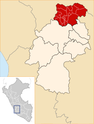
 The Acostambo District is located in the southwest of the Tayacaja Province (marked in red) |
|
| Basic data | |
| Country | Peru |
| region | Huancavelica |
| province | Tayacaja |
| Seat | Acostambo |
| surface | 164 km² |
| Residents | 3462 (2017) |
| density | 21 inhabitants per km² |
| founding | January 8, 1912 |
| ISO 3166-2 | PE-HUV |
| politics | |
| Alcalde District | Javier Romani Villalba (2019-2022) |
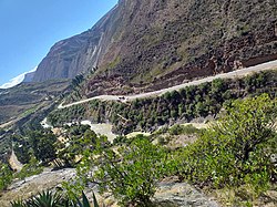
| Río Mantaro near Izcuchaca; the opposite bank belongs to the Acostambo district | |
Coordinates: 12 ° 22 ′ S , 75 ° 3 ′ W
The Acostambo District is located in the Tayacaja Province in the Huancavelica region in southwest central Peru . The district was established on January 8, 1912. It has an area of 164 km². The 2017 census counted 3462 inhabitants. In 1993 the population was 5021, in 2007 4537. The seat of the district administration is the 3600 m high village Acostambo with 958 inhabitants (as of 2017). Acostambo is located 20 km west-northwest of the provincial capital Pampas .
Geographical location
The Acostambo District is located on the western edge of the Peruvian Central Cordillera in the southwest of the Tayacaja Province. The longitudinal extent in NNW-SSE direction is 23.5 km, the maximum width is 7 km. The district extends along the eastern bank of the Río Mantaro, which flows south-southeast .
The Acostambo district borders in the south and southwest with the districts Huando , Izcuchaca , Cuenca and Pilchaca (all four in the province Huancavelica ), in the northwest with the district Ñahuimpuquio , in the north with the district Pazos , in the northeast with the district Acraquia and in Southeast to the Ahuaycha district .
Localities
In addition to the main town, the district has the following larger towns:
- Huaytacorral
- Pacchapata Baja
- Quintaojo (203 inhabitants)
- Villa Real
- Vista Alegre
Web links
- Peru: Huancavelica region (provinces and districts) at www.citypopulation.de
- INEI Perú
