Roble District
| Roble District | |
|---|---|
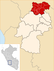
 The Roble district is located in the east of Tayacaja Province (marked in red) |
|
| Basic data | |
| Country | Peru |
| region | Huancavelica |
| province | Tayacaja |
| Seat | Puerto San Antonio |
| surface | 185 km² |
| Residents | 1377 (2017) |
| density | 7.4 inhabitants per km² |
| founding | 17th December 2015 |
| ISO 3166-2 | PE-HUV |
| politics | |
| Alcalde District | Carlos García Candiote (2019-2022) |
| Political party | Movimiento Regional Ayni |
Coordinates: 12 ° 13 ′ S , 74 ° 29 ′ W
The Roble District is located in the Tayacaja Province in the Huancavelica region in southwest central Peru . The district was formed on December 17, 2015 from parts of the Tintay Puncu district. The district of Roble has an area of 185 km². The 2017 census counted 1,377 inhabitants. The district administration is based in the village of Puerto San Antonio at an altitude of 2620 m with 567 inhabitants (as of 2017). Puerto San Antonio is located 45 km east-northeast of the provincial capital Pampas .
Geographical location
The Roble district is located in the Peruvian Central Cordillera in the east of the Tayacaja province. In the east, the district boundary runs along the Río Imaybamaba. The west and northwest is drained via the Río Paraiso, the east via the Río Imaybamaba to the Río Mantaro to the northeast.
The district of Roble borders in the far west on the district Andaymarca , in the northwest and in the north on the district Tintay Puncu and in the east and south on the district Pucacolpa ( province Huanta ).
Localities
In addition to the main town, the district has the following larger towns:
- Huallhuapampa (269 inhabitants)
- Huichcana
- San Isidro (270 inhabitants)
Web links
- Peru: Huancavelica region (provinces and districts) at www.citypopulation.de
- INEI Perú