Dominicus Street
|
|
|
|---|---|
| Street in Berlin | |
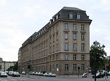
| Dominicusstrasse at the level of Feurigstrasse | |
| Basic data | |
| place | Berlin |
| District | Schöneberg |
| Created | July 31, 1947 |
| Hist. Names | Mühlenweg, Mühlenstraße, Reppichstraße, Tempelhofer Straße |
| Connecting roads |
Martin-Luther-Strasse , Sachsendamm |
| Cross streets |
Fritz-Elsas-Strasse , Hauptstrasse , Fritz-Reuter-Strasse , Feurigstrasse , Ebersstrasse |
| Buildings | Schöneberg Town Hall , St. Norbert Church |
| use | |
| User groups | Pedestrian traffic , bicycle traffic , car traffic , public transport |
| Technical specifications | |
| Street length | 800 meters |
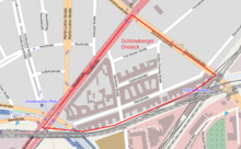
The Dominicusstraße in Berlin district of Schöneberg , with a length of about 800 meters an important urban connection from the western city in the southern districts.
Naming
Dominicusstrasse, named on July 31, 1947, is named after the politician Alexander Dominicus (1873–1945). From 1911 to 1921 he was Lord Mayor of the then independent city of Schöneberg , which became part of Greater Berlin on October 1, 1920 . The street's previous names were Mühlenweg (until mid-19th century), Mühlenstraße (mid-19th century until 1937), Tempelhofer Straße (1884-1947) and Reppichstraße (1937-1947).
Course and development
Dominicusstraße begins at the level of the Schöneberg town hall as a junction with Martin-Luther-Straße and, as an entry and exit road , connects to the Sachsendamm and the junction of the city ring road and the west bypass located there. From the main road , the route of federal road 1 runs in a south-easterly direction . Dominicusstraße turns into Sachsendamm at Schöneberg station , where the S-Bahn lines of the Ringbahn cross with the Wannseebahn . Fritz Klingholz's station building was built between 1896 and 1897 and is a listed building .


At Dominicusstraße 2–12 is the listed Olex House , built by Bielenberg & Moser between 1915 and 1922 , which houses the Senate Department for Economics. On the opposite side (house numbers 15-19) the relatively modern facade of the St. Norbert Church is striking: the entrance area, the tower and the parish and parish house of Hermann Fehling , Daniel Gogel and Peter Pfankuch date from 1960 -1962. The actual church is by Carl Kühn from the years 1913–1918. The old and new parts of the church are listed.
The rear part of the memorial area of the evangelical Paul Gerhardt Church with parish hall and superintendent from the years 1958–1962 is located in Dominicusstraße 21a .
From 1871 to 1975, the Schöneberg Castle Brewery was located northeast of the Dominicus- / Hauptstraße intersection .
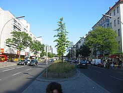
Although a large part of the southeastern Dominucusstraße survived the Second World War completely undamaged, the buildings in question were completely demolished in the 1960s and replaced by new buildings - especially the Schöneberger Terrassen - in order to double the street width.
At the end of Dominicusstraße in front of the S-Bahn bridges is the Schöneberger Tor , a residential and commercial building at Dominicusstraße 55.
In 1968, a 152-meter high steel bridge was built over Dominicusstraße to relieve traffic at the intersection of Hauptstraße . This measure was necessary because with the renovation of Innsbrucker Platz in connection with the local tunnel construction for the city motorway, traffic was no longer routed through Ebersstrasse, but via Hauptstrasse and Dominicusstrasse. After the end of the construction work, the bridge was removed again in the 1970s.
Schöneberg triangle
To the southeast is the Schöneberg triangle . It describes the area north of the Ringbahn, east of the main street and south of the Dominicusstraße with the corner points Innsbrucker Platz, intersection Dominicus- / Hauptstraße and the S-Bahn bridges at the crossing Dominicusstraße / Sachsendamm. This is where the headquarters of the Berlin Bakers' Guild are located, the Ebersstraße entrance to the Schöneberg S-Bahn station, the headquarters of the Johann Meyer bakery and the only access to the site south of the S-Bahn ring with the former disinfection station Schöneberg at Kärntener Straße 20/21 and the allotment garden colony "Maxstraße".
Web links
- Dominicus Street. In: Street name lexicon of the Luisenstädtischer Bildungsverein (near Kaupert )
Individual evidence
- ↑ Entry in the Berlin State Monument List
- ↑ Development plan XI-64 for the widening of Dominicusstrasse between Ebersstrasse and Feurigstrasse
- ↑ Tower clock with a chime adorns the "Schöneberger Tor" . In: Die Welt , November 11, 2005
- ↑ Hochstraße is built in one night . ( Memento of the original from March 4, 2016 in the Internet Archive ) Info: The archive link was inserted automatically and has not yet been checked. Please check the original and archive link according to the instructions and then remove this notice. (PDF; 770 kB) In: Berliner Anzeiger , April 25, 1968
- ↑ What rusts does not rest . In: Die Zeit , No. 7/2009
Coordinates: 52 ° 28 ′ 54.5 ″ N , 13 ° 20 ′ 55 ″ E

