Ehringhausen (Geseke)
|
Ehringhausen
City of Geseke
|
|
|---|---|
| Coordinates: 51 ° 39 ′ 29 " N , 8 ° 26 ′ 58" E | |
| Height : | 95 (94-104) m |
| Area : | 4.68 km² |
| Residents : | 1575 (Jan 31, 2018) |
| Population density : | 337 inhabitants / km² |
| Incorporation : | 1st January 1975 |
| Postal code : | 59590 |
| Area code : | 02942 |
|
Location of Ehringhausen in the city of Geseke
|
|
Ehringhausen is a village in North Rhine-Westphalia , Germany , which has belonged to the city of Geseke in the Soest district since the regional reform in 1975 .
geography
Geographical location
Ehringhausen is about four kilometers west of Geseke and seven kilometers east of Lippstadt between the northern foot of the hair strand and the lip . In the north is the lowest point at 94 m above sea level. NN ; To the south the terrain rises slightly and reaches 104 m above sea level. NN .
Neighboring places
- Geseke (east)
- Bönninghausen (east)
- Mönninghausen (north)
- Oechtringhausen (northwest)
- Dedinghausen (west)
- Ermsinghausen (southwest)
- Langeneicke (south)
- Störmede (south)
history
The first documentary mentions of the place go back to around 1350 as Erdinghusen.
In 1843 Ehringhausen was incorporated into the newly established Störmede Office and the administration was moved to Ehringhausen in 1935. The school, which had existed since 1840, was closed in 1972.
In 1881 Ehringhausen received a connection to the railway through the Royal Westphalian Railway Company .
Ehringhausen was incorporated into the city of Geseke on January 1, 1975.
politics
Head of town
Susanne Schulte-Döinghaus ( CDU )
coat of arms
The coat of arms of the village, designed in 1998, is divided into three parts and shows a white scallop shell and a five-petalled white rose on a yellow background and a yellow five-spoke wagon wheel on a red background. The shell symbolizes Ehringhausen's patron saint, Saint James. The rose goes back to the noble lords of Störmede, who had their headquarters in Störmede until around 1233. The wagon wheel was taken from the family coat of arms of Friedrich von Hörde , Albert von Störmede's heir.
Population development
|
|
Culture and sights
The cultural ring, which, as an umbrella organization, coordinates the activities of all member associations, is in charge of club life in Ehringhausen. Ehringhausen has a kindergarten which is also attended by children from the surrounding villages. There is a primary school in Störmede, secondary schools in Geseke.
Regular events
- Annual shooting festival of the St. Jakobus shooting society Ehringhausen
- Village festival every two years
- Annual village championship of the sport shooting club Ehringhausen 1972 e. V. in the "old school"
Buildings
- in the 17th century newly built chapel “St. James Church "
- "Old school"
Infrastructure and traffic
Ehringhausen is connected to the regional road network via two district roads and a country road in a west-east direction. With its inner-urban dominance, the Triftweg connects the two local areas "Heide" and "Dorf" in a north-south orientation. In the west lies the federal road 55 , which serves as a feeder to the federal freeway 2 in the north towards Berlin and to the A 44 in the south towards Dortmund ; the Geseke / Steinhausen junction of the A 44 leads in the direction of Kassel. South of Ehringhausen, Bundesstrasse 1 runs through Störmede as the main connection route to the cities of Soest and Paderborn.
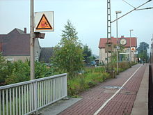
The Ehringhausen stop (Kr Lippstadt) on the Hamm – Warburg line is served every half hour by the regional train RB 89 Ems-Börde-Bahn ( Münster - Hamm - Paderborn - Warburg ). The core town of Geseke has another train stop.
A bus line (Geseke-Lippstadt) runs through Ehringhausen. School buses also serve the towns of Garfeln , Bönninghausen and Störmede.
Paderborn / Lippstadt Airport is twelve kilometers southeast of Büren - Ahden . It can be reached quickly and easily via the A 44.
swell
- ↑ City of Geseke: Facts and Figures (accessed on February 21, 2018)
- ^ Federal Statistical Office (ed.): Historical municipality directory for the Federal Republic of Germany. Name, border and key number changes in municipalities, counties and administrative districts from May 27, 1970 to December 31, 1982 . W. Kohlhammer, Stuttgart / Mainz 1983, ISBN 3-17-003263-1 , p. 334 .
- ↑ City of Geseke - Ortsvorsteher ( Memento of the original from March 14, 2012 in the Internet Archive ) Info: The archive link was inserted automatically and has not yet been checked. Please check the original and archive link according to the instructions and then remove this notice. (accessed on June 17, 2011)
- ↑ City of Geseke: History of the coat of arms of the Ehringhauser village coat of arms ( Memento of the original from September 28, 2007 in the Internet Archive ) Info: The archive link was automatically inserted and not yet checked. Please check the original and archive link according to the instructions and then remove this notice. (accessed on June 4, 2011)
- ↑ City of Geseke: History Ehringhausen ( Memento of the original from June 18, 2006 in the Internet Archive ) Info: The archive link was inserted automatically and has not yet been checked. Please check the original and archive link according to the instructions and then remove this notice. (accessed on June 4, 2011)


