
Lößnig-Dölitz recreation park

The Lößnig-Dölitz recreation park is one of the youngest and largest parks in Leipzig . It was created on a site under which underground lignite mining was once operated. The park is an extensive meadow area made up of individual trees and groups of trees and interspersed with bodies of water with different adventure areas.
location and size

The Lößnig-Dölitz recreation park is located in the south of the city and includes areas in the districts of Lößnig , Dölitz , Dosen and Probstheida . It is bounded in the north by the Lößnig development area, allotment gardens, a sports field and Connewitzer Strasse, in the east by allotment gardens belonging to Probstheida, in the south by Gorbitzer Strasse and in the west by allotment gardens, the former Dölitz mine and the housing development of the Rundling . It can be reached via the Lößnig terminal with tram lines 10 and 16. The area of the park is 95 hectares.
Sometimes the now greened former rubbish dump Leinestrasse and the forest area to the east are counted as part of the park. The total area is the conservation area Lößnig-Dölitz with an area of 395 hectares. The recreation area is an important link in the south-east of Leipzig's green belt, which extends from the historic Johannistal allotment garden to the Friedenspark , Wilhelm-Külz-Park , the Südfriedhof , the Markkleeberger Weinteichgraben area and the post- mining landscape of the Espenhain opencast mine with the Markkleeberger and the Störmthaler See extends.
history

In 1959, the mining of lignite in the lignite underground mine Schacht Dölitz was stopped due to unprofitability. Until then, lignite had been mined in an area of around 400 hectares east of the shaft at a depth of 60 to 80 meters. Most of the stretches were then backfilled. Nevertheless, subsidence occurred in some cases, but this still allowed the area to be used for agriculture.
Since the 1960s, the GDR's annual agricultural exhibition "agra" in Markkleeberg has used large parts of the area for field demonstrations of new agricultural techniques and methods.
From 1971 to 1975 a new building area with over 3000 apartments was built in the neighboring area around Zwickauer Straße in Lößnig, which resulted in an acute need for local recreation. The quarry field of the mine, which had already received the status of a landscape protection area in 1962, offered itself for this. From 1975 to 1984 the recreation park was gradually built in its central part. Park areas, plantings and a network of paths were defined, taking into account the landscape features such as the relief of the terrain, woodland and water. In 1994 another landscape planning development concept was worked out, which for example provided for further afforestation and the integration of the biotopes.
Experience areas


Bodies of water
The largest of the three bodies of water in the park is the reservoir . It was created when, at the end of the 1960s, a dam was built in a small trickle through a damp depression in order to obtain a water supply that was used to demonstrate irrigation systems on the neighboring shovel fields of the agra exhibition. It has an area of 5.52 hectares. It was declared a regional natural monument in 1993 and today, with its reed zone, offers water birds and small organisms an ideal habitat. Because damage was caused by the floods in 2013 , the dam and control organs had to be replaced. The reservoir is often, but incorrectly, referred to as the silver lake.
At 0.74 hectares, the Silbersee is the smallest of the park waters. It is located in the central area of the park and was created by a funnel-shaped incision in an unfilled pit, in which surface water has collected over the years. It is already listed without a name in a city map from 1946.
The shepherd's pond (1.21 hectares) is located like the reservoir in the western area of the park and was also created in a collapse of the mining area. Like the Silbersee, it has reed areas on the bank that allow special biotopes .
Ditches run to the ponds and between them (Lößniger Stauteichgraben, Silberseegraben, Schäfereiteichgraben), but they do not always carry water and can form even more small water areas when there is a high water supply.
Sport and play
In the part of the park close to the Lößnig housing estate, there are playgrounds for children of different ages.
In the vicinity of the Silbersee there is an asphalt track laid out in several loops, which can be used both for roller skating and for operating remote-controlled model cars .
The extensive network of trails offers good opportunities for exercise.

gastronomy
The restaurant in the park is called "Zur Schäferei" and underpins its name with a couple of live sheep in a gate. It is located near the sheep farm, which you can see from the outdoor seating area. A wooden cart with a shepherd and his small herd in front of the restaurant - built around 2013 to replace an earlier team of buffalo - is an attractive attraction for children.
various
In some places there are bronze sculptures that, like a pergola , underline the park character of the complex.
To the south, the park is connected to the Leinestrasse heap, which is up to 25 meters high and can be accessed from the park side. It was built after the Second World War from rubble from the south of Leipzig and was later used by the Leipzig garbage disposal until it was finally closed in 1979. It is now largely forested and there are meadows on the plateau. The Halde is a good vantage point both to the north over the park and the city and on the opposite side over the southern Leipzig foreland. The dump is popularly referred to as "ash mountain".
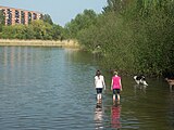 The reservoir
 "To the sheep farm" restaurant
 The buffalo cart
(until around 2013)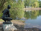 At the sheep farm
 Fast models


During the reforestation in the northern part of the park area in 1996, an area of around six hectares was created as a forest arboretum . For this purpose, foreign tree species were planted in groups, for example from eastern North America swamp oak , silver maple and tulip tree , from western North America giant arborvitae , sitka spruce , Douglas fir and giant sequoia , from Asia ginkgo , god tree and Maximowicz birch (also emperor birch ) as well as sweet chestnut , walnut and service tree from Europe .
From 1996 to 2011 the Saxonia International Balloon Fiesta took place in the Lößnig-Dölitz Recreation Park, especially on the large meadow by the reservoir, on the last weekend of July , a meeting of hot air balloon drivers from all over Europe, which had the character of a folk festival and, in particular, thousands of people during the evening balloon glow Attracted visitors.

Web links
Individual evidence
- ↑ Lößnig-Dölitz Recreational Park leaflet from the Leipzig Green Spaces Office 1998
- ↑ Landscape protection areas of Leipzig on the website of the city of Leipzig
- ↑ Horst Riedel: Stadtlexikon Leipzig from A to Z . PRO LEIPZIG, Leipzig 2005, ISBN 3-936508-03-8 , p. 369
- ^ Lakes and Ponds in Leipzig ( Memento from February 17, 2012 in the Internet Archive ) on the website of the City of Leipzig
- ↑ Dam structure on the Silbersee is almost finished. City of Leipzig, February 21, 2018, accessed on August 7, 2018 .
- ↑ Waldarboretum ( Memento from June 16, 2012 in the Internet Archive ) on the website of the City of Leipzig
Coordinates: 51 ° 17 ′ 47.8 ″ N , 12 ° 24 ′ 18 ″ E