Eula (river)
|
Eula obsolete Eyla, owl |
||
|
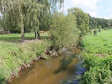
The Eula at Kitzscher |
||
| Data | ||
| Water code | DE : 566688 | |
| location | Saxony , Germany | |
| River system | Elbe | |
| Drain over | Wyhra → Pleiße → Weisse Elster → Saale → Elbe → North Sea | |
| source | at Geithain -Wickershain 51 ° 1 '43 " N , 12 ° 42' 47" O |
|
| Source height | 255 m | |
| muzzle | in the Wyhra bei Großzössen Coordinates: 51 ° 9 '16 " N , 12 ° 27' 33" E 51 ° 9 '16 " N , 12 ° 27' 33" E |
|
| Mouth height | 132 m | |
| Height difference | 123 m | |
| Bottom slope | 4 ‰ | |
| length | 31 km | |
| Catchment area | about 171 km² | |
| Discharge at the Kesselshain gauge 1 A Eo : 160.01 km² Location: 4.1 km above the mouth |
NNQ (03/11/1972) MNQ 1972/2010 MQ 1972/2010 Mq 1972/2010 MHQ 1972/2010 HHQ (09/28/2010) |
0 l / s 141 l / s 909 l / s 5.7 l / (s km²) 9.15 m³ / s 42.8 m³ / s |
| Left tributaries | Salzbach | |
| Right tributaries | Kalkbach, Frankenhainer Bach, Kleine Eula, Heinersdorfer Bach, Hanggraben, Jordanbach, Fipperbach, Goldener Born | |
| Medium-sized cities | Districts of Borna | |
| Small towns | Districts of Geithain and Frohburg |
|
The Eula is a tributary of the Wyhra in northwestern Saxony . It has a length of 31 kilometers and a catchment area of around 171 km².
course

The Eula rises in the Eulawäldchen south of the Geithain district of Wickershain. It crosses Geithain, where it flows through the Oberfürstenteich at the outdoor pool. Behind Geithain it takes the Salzbach from the left and the Kalkbach from the right. It reaches Prießnitz via Niedergräfenhain, Frauendorf and Hermsdorf. The Frankenhainer Bach and the Kleine Eula flow here from the right. It flows over Flößberg and Beucha towards Kitzscher after it has taken up the Heinersdorfer Bach and the Steingrundbach before Beucha.
While the Eula has been straightened for long stretches, between Beucha and Kitzscher it still has near-natural flow stretches with meanders , sandbanks and ponds .
After taking in the Jordanbach in Kitzscher, it turns from the predominantly north-westerly direction to a south-westerly to westerly direction. Past Braußwig , Dittmannsdorf and Eula , where it has been flowing again for about half a kilometer through its old, winding bed since 2009, the Eula finally crosses under the federal highway 95 . It then flows on between Haubitz and the Witznitz reservoir and after a total of 31 kilometers flows into the Wyhra at Großzössen , which reaches the Pleiße after a further two kilometers .
Tributaries
- Salzbach
- Kalkbach
- Frankenhainer Bach
- Little owl
- Heinersdorfer Bach
- Steingrundbach
- Jordanbach
Places on the Eula
- Wickershain (to Geithain)
- Geithain
- Niedergräfenhain (to Geithain)
- Frauendorf (to Frohburg )
- Hermsdorf (to Frohburg)
- Prießnitz (to Frohburg)
- Flößberg (to Frohburg)
- Beucha (to Bad Lausick )
- Kitzscher
- Braußwig (to Kitzscher)
- Dittmannsdorf (to Kitzscher)
- Eula (to Borna)
- Howitzer (to Borna)
- Großzössen (to Neukieritzsch )
use
In 1815 August Schumann wrote in the State, Post and Newspaper Lexicon of Saxony about the Eula as a river: “ Its water drives six important mills. “None of them are in operation today.
In contrast, the entire length of the river is still advertised as a fishing route and is looked after by the Anglerverband Leipzig eV. The fishing classification of the river provides information about the water quality. The Eula is a cyprinid water , which means that it has the second highest quality level. Salmonid water quality is not achieved because the summer warming in the open fields and the still existing wastewater load oppose this. In the Eula, in addition to whitefish , small carp and tench can be found, which get into the stream when fishing from the rearing ponds located at the Eula tributaries.
The Borna River Management is responsible for the maintenance and care of the Eula, which is classified as a first-order body of water in the district of Leipziger Land.
Individual evidence
- ↑ a b HWSK Wyhra / Eula in the RB Leipzig Annex 10.7 Hazard map city of Bad Lausick Location Beucha, page 4, State Environmental Agency Leipzig, State Reservoir Administration of the Free State of Saxony, Reservoir Maintenance Department Untere Pleiße, April 2005, On: Environment.sachsen.de (PDF, German, 69.6 kB)
- ↑ Hydrological Handbook. (PDF; 637 kB) Part 3 - Main aquatic values. Free State of Saxony - State Office for Environment and Geology, p. 96 , accessed on December 25, 2017 .
- ↑ Requirements of the Water Framework Directive for the development of waters - process of implementation of measures in Saxony Landesdirektion Leipzig, October 2011, on: iws.htwk-leipzig.de (pdf; 9.8 MB)
- ↑ Eyla . In: August Schumann : Complete State, Post and Newspaper Lexicon of Saxony. 2nd volume. Schumann, Zwickau 1815, p. 590.
- ^ Website of the anglers' association
- ^ River Management (FM) Borna
Web links
- Description of the river by the Leipzig Anglers' Association for the upper and lower reaches of the Eula.

