
Welschenrohr
| Welschenrohr | |
|---|---|
 |
|
| State : |
|
| Canton : |
|
| District : | Thal |
| BFS no. : | 2429 |
| Postal code : | 4716 |
| Coordinates : | 606830 / 236756 |
| Height : | 680 m above sea level M. |
| Height range : | 600-1286 m above sea level M. |
| Area : | 13.01 km² |
| Residents: | 1115 (December 31, 2018) |
| Population density : | 86 inhabitants per km² |
| Website: | www.welschenrohr.ch |
 Welschenrohr with his Fluh |
|
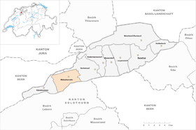
| Location of the municipality | |
  |
|
Welschenrohr is a municipality in the Thal district in the canton of Solothurn in Switzerland . The French name of the municipality is Rosières .
geography

Welschenrohr lies at 680 m above sea level. M. , 13 km west-southwest of the district capital Balsthal and 8 km north of the canton capital Solothurn (linear distance). The former street line village extends on the northern side of the Dünnern in a wide valley basin , at the northern foot of the Weissenstein range in the Solothurn Jura .
The area of the 13.0 km² municipal area comprises a section in the western part of the Balsthaler or Dünner valley, a longitudinal valley in the Solothurn Jura. The central part of the area is formed by the broad valley plain of the Dünnern, which rises on the Jura slopes west of Welschenrohr. While the western border is arbitrarily drawn across the valley, the eastern border runs in the area of the Hammerrain , a valley bar that separates the Welschenrohr basin from the main part of the Balsthalertal, which is around 150 m below. The Wolfsschlucht opens out from the north at this bar .
To the north, the municipality extends over an initially gently rising meadow slope, which is above about 800 m above sea level. M. merges into a steep forest slope, except for the anticline of the Harz chain. The border here does not run on the watershed, but on the striking ridge of Malmkalk , which is divided by the Harz Gorge into a western part (in Schwang 1239 m above sea level ) and an eastern part (in the Rinderberg 1186 m above sea level ) becomes. The landmark of Welschenrohr is the Fluh , a long, rugged rock face on the southern slope of the Rinderberg between the Harzergraben and the Wolfsschlucht.
Also on the Weissenstein chain, the southern border of Welschenrohr is not on the ridge, but on the Malmkalkkrete. The community ban includes the Schitterwald on the northern slope of the Hächler , on which at 1283 m above sea level. M. the highest point of Welschenrohr is reached, and the Solmattwald on the northern slope of the Chamben . In between there are the erosion valleys of Schofbach and Chrütlibach (both flow into the Dünnern at Welschenrohr), which have sunk deep trenches into the Jura chain over time. In 1997, 5% of the municipal area was in settlements, 59% in forests and woodlands, 35% in agriculture and a little more than 1% was unproductive land.
Welschenrohr has numerous individual farms in the valley and on the sunny slope above the village. Neighboring communities of Welschenrohr are Herbetswil , Balm bei Günsberg , Rüttenen , Oberdorf and Gänsbrunnen .
population
With 1,068 inhabitants (as of December 31, 2019) Welschenrohr is one of the medium-sized communities in the canton of Solothurn. The population of Welschenrohr was 721 in 1850 and 893 in 1900. In the course of the 20th century, the population rose continuously to 1,476 people by 1960. Due to the economic crisis, there was strong emigration during the 1970s, the population decreased by 22% to 1,114 people by 1980. Since then, only minor fluctuations in the number of inhabitants have been recorded.
economy
Welschenrohr used to be a predominantly agricultural village, but iron smelting and later a glassworks developed as early as the 17th century. The hydropower of the Schofbach and the Dünnern was previously used to operate several mills. Towards the end of the 19th century the watch industry gained a foothold in the village, which dominated the economic structure until the “ Tourist ” watch factories closed during the watch crisis in the late 1960s and “Technos” ( Gunzinger brothers ) in 1980. So Welschenrohr was one of the centers of the Solothurn watch industry for a long time.
Even today, arable farming and fruit growing (in the lower elevations) as well as dairy farming and cattle breeding have a certain role in the income structure of the population. Numerous other jobs are available in the commercial and service sectors. The industry diversified in the 1980s through the actions of the local economic development commission. In Welschenrohr, companies from the electronic industry and precision mechanics as well as the building trade, wood processing, mechanical engineering, the pharmaceutical industry and printing companies (including a textile printing company) are represented. Compared to other municipalities, Welschenrohr has relatively few commuters thanks to its commercial and industrial operations.
traffic
The community is very well developed in terms of transport. It is located on the main road from Oensingen to Moutier . Welschenrohr is connected to the public transport network through a post bus course , which covers the route from Balsthal to Gänsbrunnen.
history
The first written mention of the place took place in 1179 under the name Rore . In 1439 the name Welschen Ror appeared . The French name Rosières has been handed down from 1444 . According to an older view, the place name goes back to the Latin word rosaria , which denotes an area where reeds and rushes grow. The adjective welsch (Romansh) was added relatively late in order to distinguish it from other localities with the same name. According to the name researcher Rolf Max Kully, the name is of German origin "za demu rore" and means for reeds .
Welschenrohr has been owned by the Moutier-Grandval Abbey since it was first mentioned . As a fiefdom of the Bishop of Basel , the village became dependent on Solothurn in 1427, which from then on exercised high jurisdiction. Welschenrohr came to Solothurn through purchase in 1569 with all rights (church law, tithe, lower jurisdiction) and was assigned to the Falkenstein bailiff. The next place of justice was Matzendorf.
After the collapse of the Ancien Régime (1798) Welschenrohr was assigned to the Balsthal-Thal district. With the establishment of the Société d'horlogerie à Rosières SA in 1891, the village developed into a center of the Solothurn watch industry. Watchmaking flourished especially after the Second World War . At the time of the boom, more than 600 workers were employed in the clockworks. However, the crisis of the 1970s then led to the closure of the eight factories that were formerly eight and to a significant loss of population. In 1980 the last watch factory ceased operations. Since then, the industry has focused on modern technologies in electronics and precision mechanics.
Attractions
The Catholic Church of Saint Theodul was built from 1673 to 1677 and expanded in 1928. It stands on the site of the former St. Nicholas Chapel, which belonged to the Moutier-Grandval monastery. Welschenrohr has also been an independent parish since 1604. The Reformed Church is a modern building that was consecrated in 1962.
Some characteristic farmhouses from the 18th and 19th centuries have been preserved in the town center. The Lochmühle, which has now been restored and can be visited, is located on the Dünnern.
The Bärenloch , a cave in the Fluh above Welschenrohr, which is spanned by two natural bridges, is a natural attraction . The entrance to the Wolfsschlucht is to the east of the village . The area along the hiking trail is a cantonal nature reserve. A large part of the paths, steps and stream crossings were laid out over a number of years by Wilhelm Allemann (1913–2002).
photos
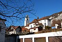
Catholic Church of Welschenrohr

The Fluh, the landmark of Welschenrohr

Wastewater treatment plant

Gasthaus Kreuz

View of Welschenrohr


coat of arms
Angled left divided by red and white, covered with a lying Flösser collar hook in alternating colors.
literature
- Gottlieb Loertscher: The art monuments of the canton of Solothurn, Volume III: The districts of Thal, Thierstein, Dorneck. (= Art Monuments of Switzerland. Volume 38). Edited by the Society for Swiss Art History GSK. Bern 1957, DNB 750089342 .
Web links
- Official website of the municipality of Welschenrohr
- Urban Fink: Welschenrohr. In: Historical Lexicon of Switzerland .
- Aerial views of the village
Individual evidence
- ↑ Permanent and non-permanent resident population by year, canton, district, municipality, population type and gender (permanent resident population). In: bfs. admin.ch . Federal Statistical Office (FSO), August 31, 2019, accessed on December 22, 2019 .
- ↑ wanderland.ch: Wolfsschlucht-Weg - Welschenrohr (Wolfsschlucht) to Welschenrohr - Wanderland Schweiz ( memento from July 24, 2011 in the Internet Archive ) , accessed on February 1, 2011