Franzosenschanze (St. Gilgen)
| Franzosenschanze ( Rotte ) | ||
|---|---|---|
|
|
||
| Basic data | ||
| Pole. District , state | Salzburg area (SL), Salzburg | |
| Judicial district | Thalgau | |
| Pole. local community | Sankt Gilgen ( KG Gschwand ) | |
| Locality | Gschwand | |
| Coordinates | 47 ° 44 '38 " N , 13 ° 23' 6" E | |
| height | 554 m above sea level A. | |
| Building status | 5 (addresses 2017 ) | |
| Post Code | 5342 Abersee | |
| Statistical identification | ||
| Counting district / district | Winkl - Ried - Gschwand (50 330 001) | |
| Source: STAT : index of places ; BEV : GEONAM ; SAGIS ; Historical fortification ( ⊙ ) | ||
Franzosenschanze is a locality in the Wolfgangsee region in the Salzburger Salzkammergut and belongs to the municipality of Sankt Gilgen in the Salzburg area . The name refers to a fortification of the Napoleonic Wars (coalition wars) .
location
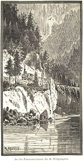
Franzosenschanze is located on the southwestern shore of Lake Wolfgang , between St. Gilgen and Abersee , about 3 kilometers from each. The Elferstein and the Troiferberg ( 883 m above sea level ), the eastern foothills of the Zwölferhorn , break here in a steep face, the Litzlwand, into the lake. The small town is on Wolfgangsee Straße (B158), right on the lake shore at 554 m above sea level. A. The wide Zinkenbach peninsula then begins to the east . The road leads over a slight hill and is a bit removed from the lake shore by a rock ridge. Opposite the lake is the Falkensteinerwand of the Schafberg.
The location includes 5 addresses.

|
Wolfgangsee
|
||

|
||
| Gschwand |
history
The location was originally run as Lueger Mühle , it belonged to the brewery Lueg north.
The fortification was built in 1809 when the Napoleonic army and its Bavarian allies threatened to invade . Except for the mountain slopes of the Zwölferhorn, entrenchments and earthworks, mainly baskets filled with stones, were thrown up. In the end, there was no fighting here.
The Ischler Railway (Salzkammergut Local Railway, SKLB) used to pass here. The site was completely changed by building roads and railways. The villa on the rock head, which still exists today and is privately owned, was built shortly after 1900 by the former director of the Burgtheater , Max Burckhard .
Infrastructure
There is a popular diving spot here, the Litzlwand continues under water, and the deepest part of Lake Wolfgang at 114 m lies between here and the Falkensteinerwand.
literature
- Friederike Zaisberger , Walter Schlegel : Castles and palaces in Salzburg. Flachgau and Tennengau . Birken series, Vienna 1992, ISBN 3-85326-957-5 , p. oA .
Web links
- Dive at Wolfgangsee Franzosenschanze . On Youtube
Individual evidence
- ↑ The name can still be found as Luger M. in the Franzisco-Josephinische (3rd) land record of the 1880s (layer online at DORIS: first land record ), and in maps as Lueger M. up to the 1960s (for example, Freitag-Berndt Hiking map No. 9 Western Salzkammergut 1: 100,000).
- ↑ a b Wolfgangsee - Salzburger Land . Dive description on zwergbuddy.de (accessed May 4, 2017).
- ↑ Dive sites Austria - Franzosenschanze. On taucher.net.

