
Fuchsmühle (Leinburg)
|
Fuchsmühle
Community of Leinburg
Coordinates: 49 ° 26 ′ 31 ″ N , 11 ° 17 ′ 9 ″ E
|
|
|---|---|
| Height : | 348 m above sea level NHN |
| Residents : | 5 (1993) |
| Postal code : | 91227 |
| Area code : | 09120 |
.jpg) The Leinburg district of Fuchsmühle
|
|
Fuchsmühle is one of 17 officially named districts of the community of Leinburg in Middle Franconia .
geography
The wasteland is located two kilometers west-southwest of the center of Leinburg and is at an altitude of 348 m above sea level. NHN . The village and the surrounding area form an exclave of the community of Leinburg, which is bordered by the community-free area of Brunn in the west and by the community-free area of Leinburg in the east . The village is located in the Nuremberg Reichswald and essentially consists only of a sawmill , a residential building and a station of the Nuremberg water supply known as the Krämersweiher waterworks , which is located at the northwest end of the original valley that ends here . East of Krämerweiher, this valley forms a deep valley cut into the Reichswald and has served the city of Nuremberg with water since 1885.
The Haidelbach , a right tributary of the Röthenbach , flows through the area from west to east in two strands. The northern branch runs through the Fuchsmühle, while the southern branch flows past the waterworks, to which the Ursprungbach (origin) flows from the left .
history
Due to the administrative reforms carried out in the Kingdom of Bavaria at the beginning of the 19th century , Fuchsmühle became part of the independent rural community of Leinburg with the second municipal edict , which also included the wasteland of Heiligenmühle and the current deserted areas of Obermühle and Roesmühle . Later there was also the desert forester's house , which did not exist at that time. In 1993 Fuchsmühle had five residents.
traffic
The place is located on the community road that leads from the Nuremberg district of Brunn to Leinburg.
Picture gallery

The fox mill
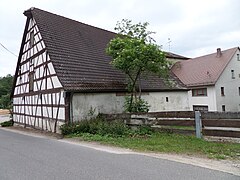
Half-timbered barn

Krämersweiher waterworks

Haidelbach at the Krämersweiher waterworks

Muzzle of the origin in the Haidelbach

_2015-06-10_18.53.05.jpg)


literature
- Eckhardt Pfeiffer (Ed.): Nürnberger Land . 3. Edition. Karl Pfeiffer's Buchdruckerei und Verlag, Hersbruck 1993, ISBN 3-9800386-5-3 .
Web links
- Fuchsmühle in BayernViewer (accessed January 27, 2018)
- Fuchsmühle on a historical map (accessed January 27, 2018)
Individual evidence
- ^ Eckhardt Pfeiffer (Ed.): Nürnberger Land . 3. Edition. Karl Pfeiffer's Buchdruckerei und Verlag, Hersbruck 1993, ISBN 3-9800386-5-3 , p. 338 .
- ↑ Fuchsmühle in the local database of the Bavarian State Library Online . Bayerische Staatsbibliothek (accessed on January 27, 2018)
- ↑ Geographical location of Fuchsmühle in the BayernAtlas (accessed on January 27, 2018)
- ↑ Origin of Nuremberg drinking water (accessed on January 27, 2018)
- ↑ OpenStreetMap: Ursprungbach (accessed on January 27, 2018)
- ↑ Karl Albert Habbe: The Aeolian Sand Deposits in Front of the Stepped Slope of the Northern Franconian Jura Announcements of the Franconian Geographical Society Vol. 44, 1997, PDF file (4 MB), page 8 (accessed on January 27, 2018)
- ↑ Political composition and ecclesiastical membership of the rural community of Leinburg (accessed on January 27, 2018)
- ^ Federal Statistical Office (ed.): Historical municipality directory for the Federal Republic of Germany. Name, border and key number changes in municipalities, counties and administrative districts from May 27, 1970 to December 31, 1982 . W. Kohlhammer, Stuttgart / Mainz 1983, ISBN 3-17-003263-1 , p. 809-812 .

Diepersdorf | Duck Mountain | Ernhofen | Forsthaus | Fuchsmühle | Gersberg | Gersdorf | Heiligenmühle | Krämersweiher | Leinburg | Oberhaidelbach | Pötzling | Pühlhof | Reuth | Scheerau | Unterhaidelbach | Weihersberg | Weißenbrunn | Winn