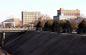
Gastonia (North Carolina)
| Gastonia | ||
|---|---|---|
 Gastonia |
||
| Location in North Carolina | ||
|
|
||
| Basic data | ||
| State : | United States | |
| State : | North Carolina | |
| County : | Gaston County | |
| Coordinates : | 35 ° 15 ′ N , 81 ° 11 ′ W | |
| Time zone : | Eastern ( UTC − 5 / −4 ) | |
|
Inhabitants : - Metropolitan Area : |
71,741 (as of 2010) 1,758,038 (as of 2010) |
|
| Population density : | 601.3 inhabitants per km 2 | |
| Area : | 119.8 km 2 (approx. 46 mi 2 ) of which 119.3 km 2 (approx. 46 mi 2 ) are land |
|
| Height : | 243 m | |
| Postcodes : | 28052-28056 | |
| Area code : | +1 704 | |
| FIPS : | 37-25580 | |
| GNIS ID : | 0985606 | |
| Website : | www.ci.gastonia.nc.us | |
| Mayor : | John Bridgeman | |
Gastonia is a city in North Carolina and has 71,741 inhabitants (2010). It is the administrative seat of Gaston County and about 119 km² in size. Gastonia is part of the Charlotte metropolitan area .
The Crescent , an Amtrak- operated passenger train, connects Gastonia with New York , Philadelphia , Baltimore , Washington, DC , Charlotte , Atlanta , Birmingham and New Orleans . The station is located at 350 Hancock Street.
Gastonia is also a quilting center .
sons and daughters of the town
- Darrell Armstrong (born 1968), basketball player
- Ezra Armstrong (* 1998), soccer player
- Fred Durst (* 1970), singer in the band Limp Bizkit
- Sleepy Floyd (born 1960), basketball player
- Maria Howell (* in the 20th century), actress
- Evan Karagias (born 1973), wrestler
- James Worthy (born 1961), basketball player
- Hassan Whiteside (* 1989), current NBA basketball player for the Miami Heat
Twin cities
Web links
Commons : Gastonia, North Carolina - Collection of pictures, videos, and audio files
Individual evidence
- ↑ Quick facts: Gastonia (English) ( Memento of the original from April 3, 2013 in the Internet Archive ) Info: The archive link was inserted automatically and has not yet been checked. Please check the original and archive link according to the instructions and then remove this notice.
