Jebel Barkal
|
|||||||||||||
|
|||||||||||||
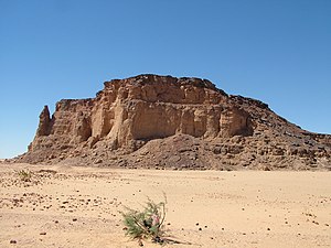
Jebel Barkal ( Arabic جبل البركل Jabal al-Barkal , DMG Ǧabal al-Barkal ; Egyptian ḏw wˁb - the pure mountain , also Gebel Barkal or Jebel Barkal , the first word is the transcription for the Arabic word "mountain", Barkal means "holy") is a small mountain in northern Sudan with a height of 287 m . The Jebel Barkal is surrounded by an extensive field of ruins, which includes several temples, important secular buildings ("palaces") and a pyramid necropolis . Together with the finds in Sanam, thebuildings formthe ancient city of Napata . Therefore, the mountain Barkal, Sanam and other sites in the area receivedthe status of World Heritage Site by UNESCO in 2003.
location
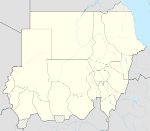
Jebel Barkal is about 30 kilometers downstream from the 4th Nile Cataract and from the new Merowe Dam , on the right bank of the Nile , about two kilometers southwest of Karima and about 400 kilometers north of Khartoum . The distance to the Nile is about 1.5 kilometers.
The mesa extends about 100 meters from the surrounding area out to the almost vertical sandstone flanks are 80 to 95 meters high, only the northern flank is less steep.
history

At least since Thutmose III. in the 15th century BC BC, from which the earliest excavated ruins come, the Egyptians regarded the Jebel Barkal as the southern counterpart to the temple complex in Karnak and as the residence of the god Amun . Until the 20th dynasty, Jebel Barkal was the most important religious center of the Egyptians in Nubia. During this dynasty, the Egyptians gradually withdrew from Nubia, the Jebel Barkal remained a politically unsecured area, and the Amun cult disappeared for a transitional period. After 1000 BC Local Nubian princes ruled. With the emergence of the Kushitic empire , whose first capital was in the 8th century BC. BC Napata with the Jebel Barkal as its center, the Amun cult was revived. Under Kashta (ruled around 760–747) the renovation and expansion of the Egyptian temples began. His son and successor Pije (ruled around 747-716) had the great temple of Amun renovated and expanded by Jebel Barkal . In front of the vertical rock face at the southern end of the mountain there is a free-standing rock needle about 70 meters high. It was previously believed to be a heavily weathered colossal statue. More recent studies have been able to refute this, but this tip seems to have been important even in antiquity. The rock can be interpreted as a uraeus snake , the symbol of Egyptian kings. Taharqa (around 690–664 BC) and Nastasen , who lived in the second half of the 4th century BC. Ruled, have their names affixed here.
Temple precinct
In the plain to the east, directly at the foot of the mountain, are the ruins of some temples and tombs that were excavated by George A. Reisner in 1916–1920. A renewed examination of the temple ruins has been carried out with interruptions since 1987 by the Museum of Fine Arts, Boston under the direction of Timothy Kendall.
Amun temple
The Amun Temple, called B.500 , belongs to the temple district . The oldest part of the temple dates from the New Kingdom and is partly built from stone blocks in the Talatat format , which was particularly common towards the end of the 18th Dynasty . The building was significantly expanded immediately before the beginning of the 25th dynasty under King Pije . The pillars and entrances were made of sandstone, while unbaked clay bricks were used for most of the walls. Pije and Taharqa provided the temple with granite boats in relief. The construction should continue Egyptian traditions. From the 25th dynasty the Temple of Amun developed into a kind of national shrine, in which numerous Kushitic kings had steles set up with reports on their deeds in order to justify them to the deity. These steles represent one of the most comprehensive written sources on the history of the 25th Dynasty and the Napatan period.
Temple of Mut and Hathor

The ruins of the B.300 , also known as the Temple of Mut , which are best preserved after the Temple of Amun , are just under 200 meters west of it on the southern tip of Jebel Barkal below the rock needle. The original structure of the goddess Mut from the time of the New Kingdom was a free-standing temple. Under Taharqa a new temple with a pylon and axial rows of columns inside was built around 680 BC. Half built into the rock. Two pillars of the Temple of Mut with capitals showing the faces of Hathor were erected again.
25 meters to the west was the similarly large temple B.200 for the goddess Hathor, which was also partly built into the rock . Both temples pay homage to a sun cult, the myth of the Eye of Re . The Hathor Temple had three altar rooms, for Hathor, Tefnut, and another unknown goddess.
Other temples within the temple precinct
B.600 was a small temple that was first built under Thutmose IV around 1400, must have been destroyed by a rock fall and was probably rebuilt towards the end of the Napatan period . Around the same time, the 7th century B.700, which was damaged by falling rocks, was restored.
The temple B.800 (Temple of Alara) , originally made of adobe bricks, was extended by Kashta with a pylon made of stone blocks and its entrance was lined with a row of stone rams. Small remains of other temples and secular buildings were excavated between these temples. The first construction phase of the palace (B. 1200) made of mud bricks probably also took place in the time of Kushta.
City and necropolis
To the east of the temple area, a team from the University of Rome excavated the remains of several secular buildings , mostly from the Meroitic period, including a large palace from the 1st century AD. In 1994 the Italians found two lion statues there. On the opposite western side of the mountain, the Meroitic pyramids of Jebel Barkal can be seen from the thoroughfare .
See also
literature
- Dows Dunham : The Barkal Temples. Excavated by George Andrew Reisner . Museum of Fine Arts, Boston MA 1970.
- Timothy Kendall: Excavations at Gebel Barkal, 1996. Report of the Museum of Fine Arts, Boston, Sudan Mission. In: Kush. Vol. 17, 1997, ISSN 0075-7349 , pp. 320-343.
- Timothy Kendall: The Kings of the Holy Mountain. Napata and the Cushite Dynasty. In: Dietrich Wildung : The Pharaohs of the Goldland. Ancient kingdoms of Sudan. Reiss-Museum, Mannheim 1998, ISBN 3-8030-3090-0 , pp. 161-171.
- Timothy Kendall: Gebel Barkal. In: Kathryn A. Bard (Ed.): Encyclopedia of the Archeology of Ancient Egypt. Routledge, London 1999, ISBN 0-415-18589-0 , pp. 325-28.
- Richard Lepsius : Monuments from Egypt and Ethiopia. Text volume 5: Walter Wreszinski : Nubia, Hammamat, Sinai, Syria and European museums. Hinrich, Leipzig 1913, p. 256ff.
Web links
- Entry on the UNESCO World Heritage Center website ( English and French ).
- Timothy Kendall: The NCAM Mission at Jebel Barkal. NCAM, Sudan ( Memento from June 13, 2010 in the Internet Archive )
- Timothy Kendall: Gebel Barkal and Ancient Napata. ARKAMANI Sudan Electronic Journal of Archeology and Anthropology
- Timothy Kendall: Napatan Temples: A Case Study from Gebel Barkal. ( MS Word ; 430 kB)
- Gebel Barkal - The sacred mountain of the black pharaohs. In “Treasures of the World. Heritage of Humanity ”.
Individual evidence
- ↑ VI. Current Archaeological Teams. jebelbarkal.org
- ↑ Kendall 1998, p. 163


