Achterhoek
| province |
|
|
Area - land - water |
1,561.08 km 2 1,544.7 km 2 16.38 km 2 |
| Residents | 400,422 (May 31, 2018) |
| Coordinates | 52 ° 0 ′ N , 6 ° 23 ′ E |
| Important traffic route |
|
| prefix | 0313, 0314, 0315, 0543, 0544, 0545, 0573, 0575 |
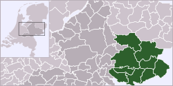
The Achterhoek ( German rear corner , Low German Achterhook ) refers to that part of the Dutch province of Gelderland , previously County of Zutphen , which is east of the Gelders Issel and west of North Rhine-Westphalia . The term, first used in a verse by the poet Willem Sluyter (1627–1673) from Neede, originally referred to the whole of the Netherlands (and parts of Germany ) east of the Gelders Issel.
In the course of time, however, use has been restricted to the Geldern part of this area, which is limited in the west by the IJssel , in the southwest by the Issel , in the southeast and east by Germany and in the north by the Überissel areas of Salland and Twente . In the Middle Ages, the name Hamaland was also common.
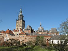
The Achterhoek is an agricultural area with recently significant tourism, which markets the scenic beauty and many castles. Well known is the Grolsch beer brand , which was formerly produced in Groenlo .
The spoken dialect in the Achterhoek is, as in the northern provinces of Overijssel, Drenthe and Groningen, Lower Saxony .
The population is predominantly Protestant; some places are mostly Roman Catholic.
The public libraries in the Achterhoek are part of the Achterhoekse Poort library network .
The Achterhoek is often referred to as De Graafschap , although this name originally refers to the former County of Zutphen, which covers roughly the same area.
Municipalities in the Achterhoek
- Aalten
- Berkelland
- Bronckhorst
- Doesburg
- Doetinchem
- Lochem
- Oost Gelre
- Oude IJsselstreek
- Winterswijk
- Zutphen
See also
There are also three villages named Achterhoek , see
- Achterhoek ( Hof van Twente ) -NL
- Achterhoek ( Nijkerk ) -NL
- Achterhoek ( City of Kevelaer )
Web links
- Website of the Regio Achterhoek (Dutch)
Individual evidence
- ↑ Bevolkingsontwikkeling; regio per maand Centraal Bureau voor de Statistiek , accessed on July 1, 2018 (Dutch)
- ↑ cf. Map of the historical Lower Saxony-Lower Franconian dialect border


