
Bell (Bayreuth)

Glocke is a district in the south of Bayreuth . It lies between the barracks district , the valley of the Aubach , the Saas and the parcel of Lerchenbühl. The quarter is also referred to as "bells" on some plans.
History and description


The name is believed to be derived from a wooden alarm bell from the Thirty Years' War that was located at this point. The Einödhof Glockengut in the center of the settlement Holzerne Glocke can be traced back to the 18th century and was already part of the urban area. The first houses on Pottensteiner Strasse were built in 1930–1932, a much larger part of the settlement between 1934 and 1936. In terms of urban planning, the villa settlement is similar to the garden city , but the developers were two private local construction companies. The development along Ludwig-Thoma-Straße and to the west of it dates from the 1950s and 1960s. After the Second World War , most streets were given names of poets, writers and philosophers or were renamed accordingly ( Gerhart-Hauptmann-Straße , Max-Stirner-Straße , Schopenhauerstraße ).
The Glocke-Süd industrial park borders the northern edge of the settlement . The greater part of the Glocke industrial park lies north of the former Bayreuth – Hollfeld railway line (now the cycle path), which spatially separated the area. In addition to warehouses (formerly with rail connections), there are large industrial and retail businesses here. After the departure of a local haulage company in 2016, a residential complex is to be built on its former site under the name "Glockengut".

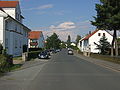
Glockenstrasse on Ludwig-Thoma-Strasse
Glockenstrasse

Otto-Hahn-Strasse in the Glocke-Süd industrial park with a warehouse


Pottaschhütte

On the Stierlein military map from 1799 still marked as “Pottaschütte”, the Pottaschhütte (local emphasis on the 'a') was a commercial property. In 1743 the Bayreuth merchant Schilling acquired land in Lerchenbühl from the fields of the Saaser farmer Meyer in order to build a factory. Since that year, potash (potassium carbonate) has been obtained there by leaching wood ash, which was used, among other things, in glass and soap production. From 1769 until the end of operations in 1800, around 20 people were employed and lived in the neighboring Glockenhof, which was demolished in 2003.
In 1830 the Saas farmer Meyer bought the property. From 1833 the building was used as a restaurant, from 1933 to 1951 it served as a school for the primary school students from the Glocke, the Saas and the Birken, as well as a kindergarten and makeshift church. In 1977 the building was demolished, the name has been retained as the street name and designation for the surrounding area.
literature
- Herbert Popp: Bayreuth - rediscovered . Ellwanger, Bayreuth 2007, ISBN 978-3-925361-60-9 .
Individual evidence
- ↑ a b Herbert Popp: Bayreuth - newly discovered, p. 350
- ↑ a b c d Glocke, Lerchenbühl and Pottaschhütte at bayreuther-tagblatt.de from January 25, 2020, accessed on April 4, 2020
- ↑ Rosa and Volker carbon home: Bayreuth from A-Z . C. and C. Rabenstein, Bayreuth 2009, ISBN 978-3-928683-44-9 , pp. 49 u. a .
- ↑ Living for all generations in the "Glockengut" in: Nordbayerischer Kurier from August 11, 2016, p. 16
- ^ Herbert Popp: Bayreuth - newly discovered , p. 354.

Aichig | Old town * | Peasant green | Farms | Bayreuth ( historic city center ) | Birch trees * | Floor mill | Castle * | Bürgerreuth * ( Green Hill ) | Colmdorf | Destuben | Dörnhof | Dürschnitz * | Eichelberg | Hermitage | Hermit Court | Frankengut | Friedrichsthal | Prosecution | Garden City * | Vulture's Nest | Geigenreuth | Bell * | Grunau | Grunauermühle | Green tree * | Hammerstatt * | Heinersberg | Hermannshof | Hollow mill | Hölzleinsmühle | Hornsröth | Hussengut | Juchhöh | Karolinenhöhe | Karolinenreuth | Barracks district * | Cross * | Cross stone | Krodelsberg | Krugshof | Laimbach | Laineck | Latvians | Tan | Meyernberg | Meyernreuth | Moss hill | Moritzhöfen * | Mosing * | New home * | New way * | Upper Röth | Oberkonnersreuth | Oberobsang | Oberpreuschwitz | Oberthiergarten | Opelsgut | Oschenberg | Pfaffenfleck | Plantation | Powder mill | Püttelshof | Riedelsgut | Rödensdorf | Rodersberg | Rollwenzelei | Römerleithen | Römersberg | Red Hill * | Saas | St. Georgen * | St. Johannis | Shooting house | Schlehenberg | Schlehenmühle | Schupfenschlag | Seulbitz | Worry Flee | Spinning Quarter | Southwest city center * | Devil's Trench | Thiergarten | Lower Röth | Unterpreuschwitz | Fulling Mill | Weiherhaus | Wendelhöfen | Meadows | Wolfsbach | Wunau | Wondrous good
* none of the official 74 districts