
Southwest city center (Bayreuth)

The south-western city center of Bayreuth represents the link between the old city center and the peripherally located old town .
location

The area can be delimited by the Mistelbach and Hindenburgstrasse, the Hohenzollernring – Wittelsbacherring road (part of the “Stadtkernring”), Rathenaustrasse, Bismarckstrasse and Scheffelstrasse. Until its laying and canalization during the First World War , the Red Main formed the northern boundary of the area. The only way to cross it was the "Schlachthausbrücke" in the area of today's Mühltürlein / Hohenzollernring intersection.
history
Today's Altstadt district is probably older than the city of Bayreuth itself. Until the early 20th century, it was known as Altenstadt and may have previously been called "Reut".
The upstream town of Altenstadt was not incorporated into Bayreuth until 1840, but its residents already had citizenship of the city from 1480. The main traffic route between the two places ran along what is now Erlanger Strasse, what was then the “Kirchweg”, which the citizens used on their way to worship. Because according to the Bayreuth Landbuch of 1421/24, the St. Nicholas Church in Altenstadt was the “right parish church” of the city, the city church intra muros only its daughter church. The municipal “Gottesacker” (cemetery) with the first Gottesackerkirche, consecrated in 1562, had been on the north side of the Kirchweg since 1545.
From the lower gate on the Pauschenberglein, the city spread outside its wall to the north-west and south-west. The development of the lower Erlanger Straße can already be proven at the beginning of the 17th century. In 1745 the Erlanger Straße was built up to the current house numbers 24a and 31, there were also a few buildings near the cemetery. Among them was the house at Erlanger Strasse 59, where a "sick house" (hospital) was probably created as early as 1449/50. The building was rebuilt in 1580, it was given an upper floor in 1784 and was converted into a poor house in 1848. In 1979 it was demolished in accordance with the requirements of the monument protection, two years later a new building was built with the creation of the external appearance. The fountain located there was initially moved next to the Rotmainhalle, today it is on Bernd-Mayer-Platz next to the city church.
On both sides of Kulmbacher Strasse, which was paved as early as 1447 and previously known as Steingasse or Steinweg, the city grew beyond its fortifications from the 16th century. The Spitalhof can be found on its south side in 1745. The development of the area initially ended with the development of the street Graben and Wolfsgasse, the further construction activity in a western direction did not take place until the 19th century. In 1850 the development on the south side of Erlanger Strasse extended beyond what is now Hardenbergstrasse.
The historical buildings in this area, on the former street Graben, Austraße and (old) Wolfsgasse as well as on “Schoberths-Eck” fell victim to the pickaxe in the post-war period . The reason for this was the construction of the four-lane bypass road "Stadtkernring" in the 1970s. Houses on the south side of Erlanger Strasse have been preserved, including the Palais von Gleichen, built by Joseph Saint-Pierre in 1743 , which the Evangelical Reformed church has been using as a sacred building since 1755 .

Around 1900 the area south of Erlanger Straße was developed. Rathenaustraße (before 1947: Kasernstraße or 7th Infantry Regiment road) dates back to 1889 as the northern boundary of the barracks district . On the northern edge of Rathenaustraße, houses were built in the style of barracks in the course of the barracks construction, in which officers and their families lived in an upscale style. In 1893 Karlstrasse (since 1947: Albert-Preu-Strasse), in 1897 Sedanstrasse (since 1947: Oswald-Merz-Strasse) and the eastern section of Rupprechtstrasse were laid out. Bismarckstrasse was built, initially between Karlstrasse and Sedanstrasse, in 1901.
Between Erlanger Strasse and Bismarckstrasse, a suburban settlement with stately, multi-storey residential buildings was built in the style of villas. The Royal Romanian Consulate had its seat on Karlstrasse in the villa of the factory owner Adolf Bayerlein, who was also the Romanian consul .
In 1902 the Luitpold School was completed on Sedanstraße. After the Central School (today's Graserschule) and the elementary school in Sankt Georgen, it was the third large elementary school in the city. The building, which was inaugurated on September 1, 1902 and designed for 20 school classes, has not changed in its external form. It was named after Luitpold von Bayern , Prince Regent of the Kingdom of Bavaria from 1886 to 1912. During the First World War , the building was used as a military hospital .
The rental apartment complexes built by the building association on the Y-shaped part of western Rupprechtstrasse date from 1924–1926.

Albert-Preu-Strasse

Rupprechtstrasse
Luitpold School

Bismarckstrasse

Oswald-Merz-Strasse


structure

The country roads to Kulmbach and Bamberg (so-called Hohe Strasse) and Erlangen began at the lower end of today's Maximilianstrasse . While the former has lost its function as such, Erlanger Straße is still the main road to the west. The traffic in the opposite direction is taken on Bismarckstrasse and Rathenaustrasse. Between the Hohenzollernring and its union, Erlanger Strasse and Bismarckstrasse have been one-way streets since the mid-1970s.
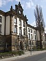
The oldest substance in the district was largely destroyed by the construction of the city center ring. The eastern Erlanger Straße lost its character, which was characterized by retail and restaurants. Leonrodstraße opened in Wittelsbacherring, but its development was retained. The Palace of Justice was inaugurated in 1904 on the corner of Wilhelminenstrasse . In the spring of 1945, several senates of the People's Court were to be relocated to the building, which was used as the “central justice building” . Opposite, at Wilhelminenstrasse 9, the University of Protestant Church Music of the Evangelical Lutheran Church in Bavaria has been located since 1953 .
Destruction of historical buildings after 1945
Erlanger Street
After 1945 the following houses were demolished:
- Erlanger Straße 2, lastly the Weißes Rössel restaurant, demolished. 1974
- Erlanger Straße 4, most recently Bavaria-Drogerie Eysser and bakery Hammon
- Erlanger Straße 6 ("Eck-Schoberth"), lastly the Schoberth restaurant, half-timbered house
- Erlanger Straße 8, lastly the Wacht dye works
- Erlanger Strasse 10, most recently the Eysser drugstore and Horlbeck stationery store
- Erlanger Straße 11, corner house on Wolfsgasse
- Erlanger Straße 12, last restaurant Unteres Tor
- Erlanger Straße 13, most recently Räbiger bicycle and sewing machine shop
- Erlanger Straße 14, most recently Schröck bicycle, sewing machine and office machine shop
- Erlanger Straße 15, lastly Rabenstein grocery store
- Erlanger Strasse 16, most recently butcher Hoffmann
- Erlanger Strasse 17
- Erlanger Straße 18, most recently the Schorr grocery store and Hertel tailoring
- Erlanger Straße 20, most recently agricultural machines, household and kitchen appliances Schorr
- Erlanger Straße 22, lastly the Lindenstuben restaurant
- Erlanger Straße 39, most recently Ullmann nursery and Pfeiffer glazier
Kulmbacher Strasse
The houses on the north side (even house numbers) are largely present from the former development. On the south side there is only one of the buildings that were still in existence in 1973 until Mistelbach with number 9.
Since 1974:
- Kulmbacher Straße 1, built in 1743, sandstone building, most recently Küffner hairdresser, demolished. 1974
- Kulmbacher Straße 2, first mentioned in 1514, sandstone building, most recently the Fischer drugstore, demolished. 1974
- Kulmbacher Straße 3, mentioned in a document in 1680, sandstone building, most recently the mechanic Frey
- Kulmbacher Straße 5, sandstone building, lastly groceries jug
- Kulmbacher Straße 7, sandstone building, built in 1745/55, birthplace of Jakob and Julius Herz , most recently butcher Eberl
- Kulmbacher Straße 11, one-storey sandstone building, around 1955 Eichmüller furniture store, demolished. 1990
- Kulmbacher Straße 13, agricultural machinery dealership Schorr, sold. 1990
dig
The street Graben almost completely disappeared when the city center ring was built. A section of the Hohenzollernring runs there today. The following were demolished:
- Graben 2, corner building to the lower Maximilianstrasse, sandstone building, last of all Küffner sanitary facilities, demolished. 1969
- Trench 4, sandstone building, demolished. 1973
Wolfsgasse
Nothing remains of the old Wolfsgasse after the city center ring was built. To the west parallel to this, a new street was laid out in 1981, which now bears this name.
Austraße
- Malting Albrecht, demolished. 1991
City cemetery

The Bayreuth city cemetery is located north of the outer Erlanger Strasse. The oldest existing cemetery in Bayreuth houses numerous grave monuments of famous personalities. It was laid out in 1545 outside the city wall and replaced the old "God's field" at the city church . This was used until 1533, in the following twelve years the dead were buried in the cemetery of the nearby Altenstadt in order to counter the risk of infection with epidemics.
Among others, the resting places of Franz Liszt , Jean Paul , Emil Warburg , Siegfried , Wieland and Wolfgang Wagner as well as the conductor Hans Richter are located in the city cemetery . The most magnificent tomb is the burial chapel of Duke Alexander von Württemberg . A commemorative plaque was put up in 1991 for Maria Anna Thekla Mozart , who was buried in the city cemetery in 1841.
The Evangelical Lutheran cemetery church is located at the southeast entrance to the cemetery. Their first building was built in 1562 and expanded in 1599. It was demolished in 1779 and replaced by the current building in 1781, which continues to be called the Gottesackerkirche in the vernacular.
Churches

- Gottesackerkirche in the city cemetery
- Evangelical Reformed Church, since 1755 at Erlanger Straße 29; the roof turret comes from the provisional Catholic church in Mistelbach, built in 1949, and was only put on in 1989
Industry and commerce

As a result of a centuries-old tradition, numerous Bayreuth citizens had the right to brew beer. For those who could not maintain their own brewery, the city created several “communal breweries”. Initially, one was located on the site of the later malt factory on Austraße. After it burned down in the middle of the 19th century, the municipal building officer Eustachius Rittler had such a facility built at Erlanger Strasse 37 in 1856. In 1930 the city sold the communal brewery to the Bürgerbräu cooperative. The listed brewhouse was integrated into a new hotel building in 1995 as a restaurant.
The Albrecht malt house was in Austraße . On the site of the factory that was demolished in April 1991 there is also a hotel today. Wolfsgasse 12 housed the Becher furniture factory, which had settled there in 1920 and still exists as a furniture store on Wittelsbacherring. The oven and pottery factory L. Seiler existed in Erlanger Straße 13 until 1960. Seiler's tiled stoves were delivered to America, the Vatican and Windsor Castle.
The granite factory Wölfel & Herold was located at Erlanger Straße 36 from 1860 to the 1960s. The company still exists on a smaller scale as a manufacturer, primarily of grave monuments. In the 1880s, the Böhmer oil and grease factory was established in Kulmbacher Straße 16, where it mainly produced lubricants until 1976 .
The municipal slaughterhouse existed between the Graben road and the Mistelbach stream from 1882 to 1993 . The foundation stone for the Rotmaincenter shopping center was laid in its place in 1996 . In 1935, north of it, at the beginning of Hindenburgstrasse, which was completed in the same year, the Rotmainhalle was built as a cattle auction hall. During the “Reichskristallnacht” of November 9, 1938, the Bayreuth Jews were rounded up and detained there. 12 of them were then deported to the Dachau concentration camp , 23 imprisoned in the Sankt Georgen prison. Today the building serves as a weekly market and sports hall.
Remarks
- ↑ The name refers to the old field name Der Stein , it was already in use before the road was paved .
Web links
literature
- Kurt Herterich : Through southwest Bayreuth . Ellwanger, Bayreuth 2001, ISBN 3-925361-39-1 .
- Kurt Herterich: A Bayreuth triangle of streets . Ellwanger, Bayreuth 1994, ISBN 3-925361-21-9 .
- Rainer Trübsbach : History of the City of Bayreuth . 1194–1994 . Druckhaus Bayreuth, Bayreuth 1993, ISBN 3-922808-35-2 .
Individual evidence
- ↑ Gottfried Lindner, Wolfgang Bouillon: Our old town. 100 years of the Bayreuth-Altstadt parish. 1898-1998 . Heinz Späthling, Ruppertsgrün 1998, p. 26 .
- ^ Rainer Trübsbach: History of the City of Bayreuth , p. 24.
- ^ Rainer Trübsbach: History of the City of Bayreuth , p. 28.
- ↑ Gottfried Lindner, Wolfgang Bouillon: Our Old Town , p. 35.
- ^ Herbert Popp: Bayreuth - rediscovered . Ellwanger, Bayreuth 2007, ISBN 978-3-925361-60-9 , pp. 146 .
- ↑ Kurt Herterich: Durchs Südwestliche Bayreuth , p. 122 ff.
- ↑ Rosa and Volker Kohlheim: Bayreuth's street names from the Middle Ages to today . In: Historischer Verein für Oberfranken (Hrsg.): Archive for the history of Upper Franconia 86th volume . Ellwanger, Bayreuth 2006, p. 57 ff .
- ↑ Kurt Herterich: Ein Bayreuther Straßenreieck , p. 7.
- ↑ Plan from 1850 at www.bayerische-landesbibliothek-online.de, accessed on August 14, 2018
- ↑ Kurt Herterich: Durchs Südwestliche Bayreuth , p. 109.
- ↑ Rosa and Volker carbon home: Bayreuth from A-Z . C. u. C. Rabenstein, Bayreuth 2009, ISBN 978-3-928683-44-9 , pp. 96 .
- ↑ Rosa and Volker Kohlheim: Bayreuth from A – Z , p. 20.
- ↑ Rosa and Volker carbon home: Bayreuth from A to Z , S. 92nd
- ↑ Rosa and Volker carbon home: Bayreuth from A to Z , p one hundred and first
- ↑ Rosa and Volker Kohlheim: Bayreuth from A – Z , p. 29.
- ↑ Kurt Herterich: Durchs Südwestliche Bayreuth , p. 145.
- ↑ Kurt Herterich: Durchs Südwestliche Bayreuth , p. 141 f.
- ↑ Bernd Mayer : Bayreuth as it was. Flash lights from the city's history 1850–1950 . 2nd Edition. Gondrom, Bayreuth 1981, p. 85 .
- ↑ Herbert Popp: Bayreuth - newly discovered , p. 147 ff.
- ↑ Kurt Herterich: Durchs Südwestliche Bayreuth , p. 88.
- ↑ Kurt Herterich: Durchs Südwestliche Bayreuth , p. 19 ff.
- ↑ Stephan-H. Fuchs: Bayreuth Chronicle 1991 . 1st edition. Gondrom, Bindlach 1991, ISBN 3-8112-0782-2 , p. 78 .
- ^ A b Bernd Mayer: Small Bayreuth City History . Pustet, Regensburg 2010, ISBN 978-3-7917-2266-5 , p. 31 .
- ↑ Bernd Mayer: Mysterious Bayreuth , p. 16.
- ↑ Stephan-H. Fuchs: Bayreuth Chronicle 1991 . Gondrom, Bindlach 1991, ISBN 3-8112-0782-2 , p. 175 .
- ^ Hermann Götzl: Bayreuth in old city views . Friends of the Historisches Museum Bayreuth eV, Bayreuth 2012, OCLC 816286405 , p. 16 .
- ↑ Kurt Herterich: Durchs Südwestliche Bayreuth , p. 111 f.
- ↑ Kurt Herterich: Durchs Südwestliche Bayreuth , p. 113 ff.
- ↑ Kurt Herterich: Durchs Südwestliche Bayreuth , p. 96 f.
- ↑ Kurt Herterich: Durchs Südwestliche Bayreuth , p. 104 f.
- ↑ Kurt Herterich: Ein Bayreuther Straßenreieck , p. 17 f.
- ^ Kurt Herterich: Ein Bayreuther Straßenreieck , p. 87.
- ↑ Bernd Mayer: Bayreuth in the twentieth century , p. 158.
- ↑ Kurt Herterich: Ein Bayreuther Straßenreieck , p. 108.
- ↑ Karl Müssel: Bayreuth in eight centuries . 1st edition. Gondrom, Bindlach 1993, ISBN 3-8112-0809-8 , p. 207 .

Aichig | Old town * | Peasant green | Farms | Bayreuth ( historic city center ) | Birch trees * | Floor mill | Castle * | Bürgerreuth * ( Green Hill ) | Colmdorf | Destuben | Dörnhof | Dürschnitz * | Eichelberg | Hermitage | Hermit Court | Frankengut | Friedrichsthal | Prosecution | Garden City * | Vulture's Nest | Geigenreuth | Bell * | Grunau | Grunauermühle | Green tree * | Hammerstatt * | Heinersberg | Hermannshof | Hollow mill | Hölzleinsmühle | Hornsröth | Hussengut | Juchhöh | Karolinenhöhe | Karolinenreuth | Barracks district * | Cross * | Cross stone | Krodelsberg | Krugshof | Laimbach | Laineck | Latvians | Tan | Meyernberg | Meyernreuth | Moss hill | Moritzhöfen * | Mosing * | New home * | New way * | Upper Röth | Oberkonnersreuth | Oberobsang | Oberpreuschwitz | Oberthiergarten | Opelsgut | Oschenberg | Pfaffenfleck | Plantation | Powder mill | Püttelshof | Riedelsgut | Rödensdorf | Rodersberg | Rollwenzelei | Römerleithen | Römersberg | Red Hill * | Saas | St. Georgen * | St. Johannis | Shooting house | Schlehenberg | Schlehenmühle | Schupfenschlag | Seulbitz | Worry Flee | Spinning Quarter | Southwest city center * | Devil's Trench | Thiergarten | Lower Röth | Unterpreuschwitz | Fulling Mill | Weiherhaus | Wendelhöfen | Meadows | Wolfsbach | Wunau | Wondrous good
* none of the official 74 districts