
Barracks district (Bayreuth)

The barracks district is a district in Bayreuth .
Surname

The district takes its name from the barracks that were built there towards the end of the 19th century for the Bavarian Army . The last barracks were given up as such in 1992 when the US troops withdrew .
After 1945 the name Industriegebiet Süd was officially used for the area, but this did not catch on. The name Röhrensee, proposed in the draft of the zoning plan, was also not accepted; the population only associates it with the nearby lake of the same name and the park surrounding it.
location
The barracks district is located south of the city center on flat terrain. It is bordered by Rathenaustraße, the Moritzhöfen district , Röhrenseepark , Justus-Liebig-Straße and the street between Leuschnerstraße and Robert-Koch-Straße.
prehistory


Bayreuth has an old tradition as a garrison town. In 1603, Margrave Christian moved his residence from the Plassenburg in Kulmbach to Bayreuth. The Jägerkaserne was built south of today's main train station , where August Neidhardt von Gneisenau performed his duties from 1783 to 1786 . After the city and the former principality were sold to the Kingdom of Bavaria , the 14th Bavarian Line Infantry Regiment moved into the city on August 17, 1810. From February 1814 the 13th Infantry Regiment was housed closed in Bayreuth, where it remained until 1866. On September 15, 1866, the 6th Chevaulegers Regiment and the first two battalions of the 7th Infantry Regiment moved into the garrison. The latter regiment was disbanded at the end of March 1919.
In 1701, Margrave Christian Ernst had a cavalry barracks built on what is now Kolpingstrasse , which was demolished in 1737 due to disrepair and replaced by a new building by 1739. 500 soldiers were housed on the upper floors of the Main Barracks and the stables on the ground floor. After joining Bavaria, the building served as an infantry barracks for around 1,000 soldiers. In 1903 the barracks were given up in favor of the new area and acquired by the city in 1912. In April 1945 it was destroyed by aerial bombs , the last remains were removed in 1948.
history


Military use
Until the second half of the 19th century, the area of the later barracks district was dominated by agriculture , the Seilersgut on today's Leuschnerstraße, which was demolished in 1937, was the only property. The main axis of the barracks district became the Hartmannstraße (since 1947 Ludwig-Thoma-Straße), laid out in a north-south direction, parallel to the east was Pottensteiner Straße and to the west of the street Von-der-Tann-Straße (from 1947 Robert-Koch-Straße) - Wörthstrasse (since 1947 Leuschnerstrasse). Xylanderstrasse (since 1947 Leibnizstrasse) and Weißenburger Strasse (since 1947 Röntgenstrasse) were built at right angles to this.
With the battalion barracks of the 1st battalion of the 7th Infantry Regiment (Prinz-Leopold-Kaserne), popularly known as the “Siebenerkaserne”, the largest structure on the area was built in 1877/78 on Kasernstrasse (since 1947 Rathenaustrasse). In 1972 the brick building was demolished without replacement and the site is now used as a parking lot. Between 1890 and 1895, two half-battalion barracks for the 3rd Battalion were built along the western Xylanderstraße on its north side, one of which was destroyed by bombs in World War II (110 dead), the other demolished in 1970. Two family buildings were built at today's Ludwig-Thoma-Strasse 2 (1888) and 6 (1894), on Von-der-Tann-Strasse a washing and bathing house (1895), a vehicle shed (1899) and a drill house (1877– 1879). Of the last three buildings mentioned, none of them exist anymore. The detention center (house number 18) was located on Ludwig-Thoma-Straße from 1896. There was also the district command building from 1879 (today's Rathenaustraße 27), the service building of the 7th Infantry Regiment (Wilhelminenstraße 7, then Heldstraße) and the garrison hospital, which was built in 1896/97 a little apart in Lazarettstraße (since 1947 Hegelstraße).
The barracks and stables of the 6th Chevaulegers Regiment stood on Geißmarkt in the 19th century. In the years 1892/93, brick-built living and stable barracks, a kitchen barrack with a wash house, a fitting forge and a riding hall were added on the east side of Hartmannstrasse. Between 1895 and 1897, the provision office with an office building, feed stores and a bakery was built between Weißenburger Strasse and Orleansstrasse. The former oat magazine burned down in a large fire in February 1963.
Almost all other buildings were not built until after the turn of the century. Between 1903 and 1928 new buildings for the 6th Chevaulegers Regiment were erected between Hartmannstrasse and Pottensteiner Strasse, many of which have survived and have been used for other purposes. From 1905 to 1907, two half battalion barracks of the 2nd Battalion of the "Sevens" were added between Xylanderstrasse and Weißenburger Strasse (Fresnoy barracks), which were demolished between 1969 and 1975. The drill house and the cartridge house were destroyed in World War II, the family building on Ludwig-Thoma-Strasse at the corner of Röntgenstrasse disappeared in 1981. The farm building, which is now used by the Bayreuth studio theater , and the staff building were preserved.
On the area of the former barracks of the 6th Chevaulegers Regiment, a barracks building was built in 1937/38, which was named after the NSDAP - Gauleiter of the Bavarian East Markets , Hans Schemm , who was killed in an accident in 1935 . In the Third Reich , the "Day of the German Wehrmacht " was held annually on the site . The gun and vehicle show with stew meals met with a great response from the population.
In 1938 a third building with a NCO barracks was built between the two Wehrmacht family buildings from 1888 and 1894 in Hartmannstrasse . A regimental headquarters and an army building were built in 1938/39 in what is now Wilhelm-Busch-Straße. This street was originally in the barracks area and initially had no name.

The second bombing raid by the US Air Force on the city on April 8, 1945 targeted the barracks district in particular. 51 B-24 machines dropped 521 bombs over Bayreuth between 12:06 and 12:08 p.m. In the Hans-Schemm-Kaserne alone, up to 170 soldiers who were just grabbing food fell victim to the attack.
US barracks
The Hans-Schemm-Kaserne was used in the post-war period by the United States Army , which kept the name until 1986. In April 1986 it was renamed the Röhrenseekaserne. The 84th engineer unit of the US armed forces was last stationed there and cleared the facilities in 1991. The North Bavarian Motorway Directorate has been located there since 1992 , followed by the Bayreuth Social Court and the Bayreuth Labor Court in 1995 .
Civil use


Before 1945 only the houses Hartmannstrasse 3 (drugstore) and 5 (bakery and beer shop) were civil buildings. At the end of the Second World War, the non-military use of the rest of the barracks area began - albeit only largely until 1992. A DP camp was set up in the Prinz-Leopold-Kaserne, which served as a residence for displaced persons from the end of World War II until the end of 1949 . In August 1949, around 1,500 people lived there, mainly Ukrainians, as well as Hungarians, Poles and Yugoslavs. In 1950 the building was rebuilt and 68 apartments were created for former residents of refugee mass camps . There was also space for three small businesses, including a butcher's and a bicycle shop.
The former NCO barracks at Ludwig-Thoma-Strasse 4 was converted into a nursing home in 1950 and inaugurated in 1951. Space for 140 people has been created in 60 rooms with running water. A green area was created in the former barracks yard, and in 1955 the foundation stone for a farm building was laid. In 1964 the home moved to a new facility, the Mühlhofer Stift in the nearby district of Birken . Police departments were housed in the buildings Ludwig-Thoma-Straße 2, 4 and 6.
In 1970 the former half-battalion barracks at Ludwig-Thoma-Strasse and Leibnizstrasse were demolished. The Technical Inspection Association (TÜV) was there until 1996 , u. a. with a vehicle inspection agency, based. Until 2015, there was a food discounter on the corner property .
From the barracks buildings on Robert-Koch-Strasse, a remnant of the vehicle depot, which had been destroyed in the war, existed until December 2014. The other buildings are more recent, such as the Bayreuth II transitional dormitory for repatriates from the former Soviet Union and a car dealership.
In the area between Leibnizstrasse and Röntgenstrasse, the parade house and the cartridge house fell victim to the war events in 1945. Remaining remains of the Fresnoy barracks, in which refugees were housed after the war, were demolished in 1969 and 1970, the family building disappeared in 1981. What remains are the former staff building (Leibnizstraße 9), which has housed a porcelain factory since 1946, and the farm building (Röntgenstraße 2 –6), in which in 1990 the studio stage found its quarters. The “Siebener” memorial on Leibnizstrasse, inaugurated in 1920, was moved to Schützenplatz in 1958, where there is now a multi-storey apartment block. On the site of the former parade house, the Bayreuth building cooperative built a “residential tower” with sixteen floors in the early 1970s.
The former oat magazine at Leuschnerstraße 51 was preserved. In the course of the industrial settlement, several companies had settled there after the end of the war. On February 26, 1963, the building was destroyed in a great fire, a silk knitting factory, a knitting and hosiery factory and a bottle cap factory fell victim to the flames. The Bayreuth office of the Bayreuth-Bamberg-Hof calibration office is now located there. The adjacent garrison officials' house was preserved in this block, as was the former detention building on Ludwig-Thoma-Straße. The former roughage store initially housed a forwarding company , but it currently houses a pharmacy. Two magazines of the same type were destroyed in the bombing war. A coal merchant initially settled on this area with a siding from the Bayreuth – Hollfeld railway line . Now there is a furniture store there and an electronics store north of it.
From the former cavalry barracks (Chevaux légers) there are still several family buildings south of Leibnizstrasse and one of the sick stables for the horses, which is a listed building. This block also houses the former double-squadron barracks, which are now used as a dormitory for asylum seekers , and former stables and coach houses that are used commercially. A textile finishing company has set up shop on Ludwig-Thoma-Straße. The opposite building at Ludwig-Thoma-Straße 18, which last housed foreign workers and asylum seekers, burned down in May 1992 and was then torn down.
In 2020 it was announced that the open area of the former US barracks would be built on. From 2022 onwards, 350 rental apartments “of good quality at affordable prices” are to be built there. A connection from Leibnizstrasse to Peter-Rosegger-Strasse is planned for pedestrians and cyclists.
Others
For the cavalry there are the terms Chevaulegers, Chevauxlegers and Chevaux légers in the literature. In local parlance, the buildings along Pottensteiner Strasse - now in commercial use - are the “Schwoläschee” barracks.
Adjacent city quarters
Southwest downtown
On the northern edge of Rathenaustraße (then: Kasernstraße), opposite the “Siebenerkaserne”, houses were built in the same architectural style as the barracks were built, in which officers and their families lived in an upscale style.
Between Leuschnerstrasse and Justus-Liebig-Strasse
On April 10, 1892, the brothel of the married couple Josef and Anna Kratz went into operation in today's Leuschnerstrasse . The establishment, run as "Weinhandlung Kratz", changed its address several times at the same location (Kasernstrasse 23 1/2 or 23, Wörthstrasse 32) and in 1904 moved to the newly built house at Wörthstrasse 48 1/2. The building was destroyed in the bombing raid on April 8, 1945.
To the south of it, at the level of today's Lessingweg, military warehouses were built in the Third Reich , which were destroyed by bombs in April 1945. From 1950 onwards, the Pöhner estate , named after the developer, was built there with simple row houses without garages.

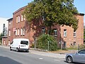
Former garrison officials' house on Leuschnerstrasse
Remaining building of the vehicle depot in Robert-Koch-Strasse, demolished in 2014

Family houses of the "Chevaux légers" in Leibnizstrasse
Former houses for officers in Rathenaustraße
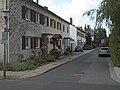
Row houses on Stifterweg in the "Pöhner-Siedlung"


Remarks
- ↑ The later Wörthstrasse and today's Leuschnerstrasse was only a cart before 1900 that branched off from Kasernstrasse.
Web links
literature
- Kurt Herterich: Southern Bayreuth . 2nd Edition. Ellwanger, Bayreuth 2009, ISBN 3-925361-26-X .
Individual evidence
- ^ Herbert Popp: Bayreuth - rediscovered . Ellwanger, Bayreuth 2007, ISBN 978-3-925361-60-9 , pp. 363 .
- ^ Kurt Herterich: From Bayreuth Castle Tower to Festival Hill . 2nd Edition. Ellwanger, Bayreuth 2003, ISBN 3-925361-47-2 , pp. 99 f .
- ↑ Herbert Popp, op.cit., P. 366.
- ↑ Kurt Herterich: In the southeast of Bayreuth . Ellwanger, Bayreuth 2000, ISBN 3-925361-38-3 , p. 8th ff .
- ↑ Udo Meixner: 70 years of the end of the war. Bayreuth and the surrounding area . 1st edition. Nordbayerischer Kurier, Bayreuth 2015, ISBN 978-3-944791-53-1 , p. 27 f .
- ↑ Stephan-H. Fuchs: Bayreuth Chronicle 1992 . 1st edition. Gondrom, Bindlach 1992, ISBN 3-8112-0793-8 , p. 60 .
- ↑ 25 years ago in: Nordbayerischer Kurier of November 17, 2015, p. 10
- ↑ Bernd Mayer : Bayreuth à la carte . Ellwanger, Bayreuth 1987, ISBN 3-925361-03-0 , pp. 148 .
- ↑ Stephan-H. Fuchs: Bayreuth Chronik 1992 , p. 94.
- ↑ To live cheaply near the Röhrensee in: Nordbayerischer Kurier from March 4, 2020, p. 7.
- ^ Wilfried Engelbrecht: Prostitution in old Bayreuth . Bayreuth slow motion, Bayreuth 2014, ISBN 978-3-9809625-1-3 , p. 82 f .
- ↑ Wilfried Engelbrecht, op.cit., P. 108 ff.
- ↑ Wilfried Engelbrecht, op.cit., P. 207.

Aichig | Old town * | Peasant green | Farms | Bayreuth ( historic city center ) | Birch trees * | Floor mill | Castle * | Bürgerreuth * ( Green Hill ) | Colmdorf | Destuben | Dörnhof | Dürschnitz * | Eichelberg | Hermitage | Hermit Court | Frankengut | Friedrichsthal | Prosecution | Garden City * | Vulture's Nest | Geigenreuth | Bell * | Grunau | Grunauermühle | Green tree * | Hammerstatt * | Heinersberg | Hermannshof | Hollow mill | Hölzleinsmühle | Hornsröth | Hussengut | Juchhöh | Karolinenhöhe | Karolinenreuth | Barracks district * | Cross * | Cross stone | Krodelsberg | Krugshof | Laimbach | Laineck | Latvians | Tan | Meyernberg | Meyernreuth | Moss hill | Moritzhöfen * | Mosing * | New home * | New way * | Upper Röth | Oberkonnersreuth | Oberobsang | Oberpreuschwitz | Oberthiergarten | Opelsgut | Oschenberg | Pfaffenfleck | Plantation | Powder mill | Püttelshof | Riedelsgut | Rödensdorf | Rodersberg | Rollwenzelei | Römerleithen | Römersberg | Red Hill * | Saas | St. Georgen * | St. Johannis | Shooting house | Schlehenberg | Schlehenmühle | Schupfenschlag | Seulbitz | Worry Flee | Spinning Quarter | Southwest city center * | Devil's Trench | Thiergarten | Lower Röth | Unterpreuschwitz | Fulling Mill | Weiherhaus | Wendelhöfen | Meadows | Wolfsbach | Wunau | Wondrous good
* none of the official 74 districts
Coordinates: 49 ° 56 ′ 3.2 ″ N , 11 ° 34 ′ 10.7 ″ E