
Saas (Bayreuth)
|
Saas
municipality Bayreuth
Coordinates: 49 ° 55 ′ 19 ″ N , 11 ° 33 ′ 38 ″ E
|
|
|---|---|
| Height : | 361 m |
| Postal code : | 95447 |
| Area code : | 0921 |
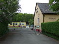
 Settlement houses in the Saas
|
|
The Saas is a district in the south of Bayreuth . It also includes the Lerchenbühl and Bärenleite districts .
location

The Saas is located south of the city center between the Glocke district , the Studentenwald recreation area and the Bärenleite-Buchstein ridge.
Surname
The name is probably a locality for a favorable settlement in the sense of "seat" ( Middle High German saz or saze ), comparable to place names such as Gesees and Aufseß . But the later village of Saas could also be a service station at the today "Hezilostraße" called old route of Creussen over the old city of Kulmbach have been.
History and description
Village


In the land register of 1398, five farms and one Selde are recorded in the Saas area . The farmers were called Ziegenthaler, Bauer, Grauenschedel and Leubser, they all paid taxes and tithes to the burgrave Johann III. von Nürnberg , who was also the chief judge . The Seldner Friedel Bauer also had Fron afford. From the village were required "to the three Weysaten" (Easter, Pentecost and Christmas) the rule with 33 cheeses additional charges beyond Easter eggs and 32 to Shrove six chickens.
The construction of a chapel can be verified in 1519, but the chapel “zur Eichen bey der saß” was closed in 1545. In connection with the Anabaptists , the Saas was mentioned in 1528 as a parish village.
settlement

Most of the buildings in the Saas were built during the “Third Reich” in the mid-1930s.
The planning of the settlement goes back to the Weimar Republic . For working-class families with many children, however, the settlement was only planned according to plan between 1934 and 1937 and built uniformly. The layout of the settlement is like a chessboard. In the core area, the building fabric of the district includes small settlement houses as semi-detached houses with a pitched roof . According to the Reichsheimstätten Act of 1920, 180 houses were built on a long-term lease on 700 square meters of land with 45 to 60 square meters of living space. The cost per house was between 2,700 and 3,500 Reichsmarks . Own work was expected to build the house, further requirements were keeping chickens and rabbits and growing food.
After 1945

After the era of National Socialism , the streets were given new names, with preference given to the names of flowers.
In the 1960s, new buildings such as the rows of terraced houses on the southern Ringweg were built, and the Church of the Resurrection was consecrated in 1964. More recent is the development with single-family houses in the area of the old village center, which is continued towards the Saaser Berg.

Long line

At the Hofacker


On the southern edge of the Saas is the southern cemetery of the city with crematorium , which was handed over in 1981, with the An der Bärenleite industrial park to the southeast . During the Nazi era, the motor sports school of the National Socialist Motor Corps (NSKK) was located there; it is currently the location of a substation .
More recently, new building areas with single-family houses have emerged south and west of the settlement.

Modern residential development on Anemonenweg

New development area on Narzissenweg

Südfriedhof


Lerchenbühl


The name Lerchenbühl can probably be traced back to a bird hearth ("Bühl") on which larks were caught.
On the Lerchenbühl parcel to the west of the bell, there is a case management ( covering shop ) recorded in the original cadastre from 1850 . The farmers were obliged to hand over all animal carcasses to the knacker. He used the leftovers and buried or burned what could no longer be recycled. Due to the nuisance caused by the smell, the fall masters were forced to live outside the town.
On the Lerchenbühl on the northern edge of the Saas, in addition to the residential development, there is the primary school of the same name, which was inaugurated in November 1951, the sports field of the BSC Saas, a tennis club and the Bayreuth animal shelter. The agricultural educational establishments ("Bezirkslehrgut") are located on the northwestern edge of the Lerchenbühl parcel. In the 1960s and 1970s, there was a campsite for caravans next to the Lerchenbühlschule .
From 1952, the Bayreuth garbage (including problematic garbage) was brought to the 4-hectare garbage dump at Am Lerchenbühl nearby . This landfill was closed in 1964, at that time there were no adequate protective measures for the environment and groundwater.

Lerchenbühlschule
Animal shelter on the Lerchenbühl


Regular events

- June: Saas Forest Festival (since 1938)
- The three-day festival of the Bayreuth-Saas Settlers and Homeowners Association in the forest at Lerchenbühl offers u. a. Live music and a children's afternoon.
Web links
- Saas (Bayreuth) in the location database of the Bayerische Landesbibliothek Online . Bavarian State Library
- District map with the BayernViewer
literature
- Herbert Popp: Bayreuth - rediscovered . Ellwanger, Bayreuth 2007, ISBN 978-3-925361-60-9 , pp. 347 ff .
Individual evidence
- ↑ a b c How the Saas got its name from bayreuther-tagblatt.de on January 14, 2020, accessed on April 4, 2020
- ^ Herbert Popp: Bayreuth - rediscovered . Ellwanger, Bayreuth 2007, ISBN 978-3-925361-60-9 , pp. 350 .
- ↑ a b c Glocke, Lerchenbühl and Pottaschhütte at bayreuther-tagblatt.de from January 25, 2020, accessed on April 4, 2020
- ^ JW Holle: History of the City of Bayreuth. Bayreuth 1901
- ↑ a b For love of the Saas in: Nordbayerischer Kurier of March 13, 2018, p. 10.
- ↑ Rosa and Volker carbon home: Bayreuth from A-Z . C. and C. Rabenstein, Bayreuth 2009, ISBN 978-3-928683-44-9 , pp. 89 u. a .
- ^ Dorothee Hochstetter: National Socialist Motor Vehicle Corps (NSKK), 1931-1945 . In: Historical Lexicon of Bavaria . Retrieved April 24, 2016.
- ↑ Bernd Mayer: Bayreuth in the twentieth century , p. 102.
- ↑ This is how it used to be in: Nordbayerischer Kurier from 4./5. April 2020, p. 10.

Aichig | Old town * | Peasant green | Farms | Bayreuth ( historic city center ) | Birch trees * | Floor mill | Castle * | Bürgerreuth * ( Green Hill ) | Colmdorf | Destuben | Dörnhof | Dürschnitz * | Eichelberg | Hermitage | Hermit Court | Frankengut | Friedrichsthal | Prosecution | Garden City * | Vulture's Nest | Geigenreuth | Bell * | Grunau | Grunauermühle | Green tree * | Hammerstatt * | Heinersberg | Hermannshof | Hollow mill | Hölzleinsmühle | Hornsröth | Hussengut | Juchhöh | Karolinenhöhe | Karolinenreuth | Barracks district * | Cross * | Cross stone | Krodelsberg | Krugshof | Laimbach | Laineck | Latvians | Tan | Meyernberg | Meyernreuth | Moss hill | Moritzhöfen * | Mosing * | New home * | New way * | Upper Röth | Oberkonnersreuth | Oberobsang | Oberpreuschwitz | Oberthiergarten | Opelsgut | Oschenberg | Pfaffenfleck | Plantation | Powder mill | Püttelshof | Riedelsgut | Rödensdorf | Rodersberg | Rollwenzelei | Römerleithen | Römersberg | Red Hill * | Saas | St. Georgen * | St. Johannis | Shooting house | Schlehenberg | Schlehenmühle | Schupfenschlag | Seulbitz | Worry Flee | Spinning Quarter | Southwest city center * | Devil's Trench | Thiergarten | Lower Röth | Unterpreuschwitz | Fulling Mill | Weiherhaus | Wendelhöfen | Meadows | Wolfsbach | Wunau | Wondrous good
* none of the official 74 districts