
Gmina Skaryszew
| Gmina Skaryszew | |||
|---|---|---|---|

|
|
||
| Basic data | |||
| State : | Poland | ||
| Voivodeship : | Mazovia | ||
| Powiat : | Radomski | ||
| Geographic location : | 51 ° 19 ' N , 21 ° 15' E | ||
| Residents : | s. Gmina | ||
| Postal code : | 26-640 | ||
| Telephone code : | (+48) 48 | ||
| License plate : | WRA | ||
| Economy and Transport | |||
| Street : | DK9 Radom - Rzeszów | ||
| DW733 | |||
| Next international airport : | Warsaw | ||
| Gmina | |||
| Gminatype: | Urban-and-rural parish | ||
| Gmina structure: | 34 school authorities | ||
| Surface: | 171.41 km² | ||
| Residents: | 14,765 (Jun. 30, 2019) |
||
| Population density : | 86 inhabitants / km² | ||
| Community number ( GUS ): | 1425103 | ||
| Administration (as of 2018) | |||
| Mayor : | Dariusz Piątek | ||
| Address: | ul.Słowackiego 6 26-640 Skaryszew |
||
| Website : | www.skaryszew.pl | ||

The Gmina Skaryszew is an urban-and-rural municipality in the powiat Radomski of the Masovian Voivodeship in Poland . Its seat is the city of the same name ( German Skaryszew ) with about 4350 inhabitants.
geography
_location_map.png)
The municipality is located in the south of the voivodeship. The border with the Heiligkreuz Voivodeship is about five kilometers to the southwest. Neighboring municipalities are the district and city of Radom in the northwest and the municipalities of Gózd in the north, Tczów and Kazanów in the east, Iłża in the south, Wierzbica in the southwest and Kowala in the west.
The rivers include the 30-kilometer-long Modrzejowianka and its tributary Kobylanka, 21 kilometers in length. The former drains into the Iłżanka .
The community has an area of 171.4 km², 77 percent of which is used for agriculture and 17 percent for forestry.
history
Interrupted by the German occupation during the Second World War from 1919 to 1975, today's municipal area belonged to the Kielce Voivodeship with different layouts. In 1922 Skaryszew was given back the town charter that had been revoked during the Russian era .
From 1975 to 1998 the municipality was part of the Radom Voivodeship . The powiat was dissolved during this time. The rural community of Skaryszew was repeatedly converted into various gromadas after 1954 and newly created on January 1, 1973. Urban and rural municipality Skaryszew were merged in 1990/1991 to form urban and rural municipality. This came in 1999 to the Masovian Voivodeship and the re-established Powiat Radomski.
structure
The town itself and 34 villages with school boards (sołectwa) belong to the town-and-country municipality (gmina miejsko-wiejska) Skaryszew with 14,765 inhabitants (as of June 30, 2019 ):
- Anielin,
- Antoniów,
- Bogusławice,
- Bujak,
- Chomentów-Puszcz,
- Chomentów-Socha,
- Chomentów-Szczygieł,
- Dzierzkówek Nowy,
- Dzierzkówek Stary,
- Edwardów,
- Gębarzów,
- Gębarzów-Kolonia,
- Grabina,
- Huta Skaryszewska,
- Janów,
- Kazimierówka,
- Kłonowiec-Koracz,
- Kłonowiec-Kurek,
- Kobylany,
- Makowiec,
- Maków,
- Maków Nowy,
- Miasteczko,
- Modrzejowice,
- Niwa Odechowska,
- Odechowiec,
- Odechów,
- Podsuliszka,
- Sołtyków,
- Tomaszów,
- Vilczna,
- Wólka Twarogowa,
- Wymysłów,
- Zalesie
In addition, there are the smaller villages Bogusławice-Kolonia, Dąbrówka Makowska and Modrzejowice-Kolonia and the hamlets of Gębarzów, Makowiec-Leśniczówka and Modrzejowice.
Listed sights
In the places of the municipality are under monument protection :
- Residential and farm buildings in Bujak, 1st half of the 19th century
- Park in Chomentów-Puszcz, 18. – 20. century
- Park in Gębarzów, 18./19. century
- Estate with outbuildings in Maków, outbuildings, granaries, distillery, 18./19. century
- Parish Church in Odechów, 15th century, 1911–1913
- Church of St. Jacob, cemetery, wall with gate and chapels in Skaryszew, 1691–1701
- Cemetery (18th century) and burial chapel of the Skorupski family (1885) in Skaryszew.

Church in Odechów

St. Jacob in Skaryszew

Sepulchral chapel in Skaryszew
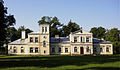
Manor house in Maków

.JPG)


traffic
The state road DK9 ( Europastraße 371 ) runs through the municipality and its main town from northwest to south. It leads from the district town of Radom to Rzeszów , the capital of the Subcarpathian Voivodeship . The intersecting voivodship road DW733 leads to the neighboring communities of Kowala and Tczów in the west and east.
The Radom railway station is the nearest train station. The nearest international airport is Warsaw , around 120 kilometers away.
Personalities
The politician Ewa Kopacz , who was Prime Minister of Poland from September 2014 to November 2015 , was born in Skaryszew in 1956.
Web links
- City and municipality website (Polish)
Individual evidence
- ↑ population. Size and Structure by Territorial Division. As of June 30, 2019. Główny Urząd Statystyczny (GUS) (PDF files; 0.99 MiB), accessed December 24, 2019 .
- ↑ a b regioset.pl: data on the municipality (Polish, accessed on May 27, 2020)
- ↑ Registered in the list of monuments of the Masovian Voivodeship under the number 821 on March 14, 1973.
- ↑ Registered in the list of monuments of the Masovian Voivodeship under the number 755 on December 19, 1957.
- ↑ Registered in the list of monuments of the Masovian Voivodeship under number 341 / A on June 10, 1986.
- ↑ Registered in the list of monuments of the Masovian Voivodeship under the numbers 802 / A and 117 / A of October 28, 1972 and July 7, 1981.
- ↑ Registered in the list of monuments of the Masovian Voivodeship under the numbers 454 / A, 84 / A, 93 / A of February 28, 1957, June 21, 1967 and March 15, 1982.
- ↑ Registered in the list of monuments of the Masovian Voivodeship under the numbers 452 / A / 57, 385 / A, 148 / A of February 28, 1957, June 21, 1967 and March 15, 1982.
- ↑ Registered in the list of monuments of the Masovian Voivodeship under the number A-1275 on November 13, 2014.