
Gmina Iłża
| Gmina Iłża | |||
|---|---|---|---|

|
|
||
| Basic data | |||
| State : | Poland | ||
| Voivodeship : | Mazovia | ||
| Powiat : | Radomski | ||
| Geographic location : | 51 ° 10 ' N , 21 ° 14' E | ||
| Height : | 180 m npm | ||
| Residents : | s. Gmina | ||
| Postal code : | 27-100 | ||
| Telephone code : | (+48) 48 | ||
| License plate : | WRA | ||
| Economy and Transport | |||
| Street : | DK9 Radom - Rzeszów | ||
| DW747 Iłża– Lipsko | |||
| Next international airport : | Warsaw | ||
| Gmina | |||
| Gminatype: | Urban-and-rural parish | ||
| Gmina structure: | 31 school authorities | ||
| Surface: | 255.82 km² | ||
| Residents: | 14,701 (Jun. 30, 2019) |
||
| Population density : | 57 inhabitants / km² | ||
| Community number ( GUS ): | 1425033 | ||
| Administration (as of 2018) | |||
| Mayor : | Przemyslaw Burek | ||
| Address: | ul.Rynek 11 27-100 Iłża |
||
| Website : | www.ilza.pl | ||

The Gmina Iłża is an urban-and-rural municipality in the powiat Radomski of the Masovian Voivodeship in Poland . Its seat is the city of the same name ( German Ilza ) with about 4700 inhabitants.
geography
_location_map.png)
The municipality is located in the south of the voivodeship and borders there and to the west on the Świętokrzyskie Voivodeship . The district town of Radom is 20 kilometers to the north, Kielce about 50 kilometers to the southwest. Neighboring municipalities are the municipalities of Wierzbica in the northwest and Skaryszew and Kazanów in the north, Ciepielów in the northeast and Kłecko in the east, in the Świętokrzyskie Voivodeship the municipalities of Brody in the south and Mirzec in the west.
The most important river is the 77-kilometer-long Iłżanka , which is dammed into a smaller lake south of the main town.
The community has an area of 255.8 km², 53 percent of which is used for agriculture and 39 percent for forestry.
history
Interrupted by the German occupation during the Second World War from 1919 to 1975, today's municipal area belonged to the Kielce Voivodeship with different layouts. The powiat Iłżecki, which already existed in Russian times, was named after Iłża, but had its seat in Starachowice . In 1924 Iłża was given back the town charter that had been revoked during the Russian era .
From 1975 to 1998 the municipality belonged to the considerably reduced Kielce Voivodeship. The powiat (renamed Powiat Starachowicki in 1973) was dissolved during this time. The rural community of Iłża was created on January 1, 1973 from different gromadas . The town and country municipality of Iłża were merged in 1990/1991 to form the town and country municipality. This came in 1999 to the Masovian Voivodeship and Powiat Radomski.
structure
The town itself and 27 villages with school boards (sołectwa) belong to the town-and-country community (gmina miejsko-wiejska) Iłża with 14,701 inhabitants (as of June 30, 2019 ):
- Alojzów,
- Białka,
- Błaziny Dolne,
- Błaziny Górne,
- Chwałowice,
- Florencja,
- Gaworzyna,
- Jasieniec Iłżecki Dolny,
- Jasieniec Iłżecki Górny,
- Jasieniec-Maziarze,
- Jedlanka Nowa,
- Jedlanka Stara,
- Kajetanów,
- Koszary,
- Kotlarka,
- Krzyżanowice,
- Małomierzyce,
- Maziarze Nowe,
- Maziarze starlings,
- Pakoslaw,
- Pastwiska,
- Pieńki,
- Piłatka,
- Płudnica,
- Predocin,
- Prędocinek,
- Prędocin-Kolonia,
- Seredzice,
- Seredzice-Zawodzie,
- Starosiedlice,
- Walentynów
Villages without Schulzenamt are Kolonia Seredzice, Krzewa, Michałów, Nowy Jasieniec Iłżecki and Piotrowe Pole. Then there are Jedlanka-Kolonia and the hamlets of Budy, Łąki, Lipie, Marcule, Pod Lasem and Stanisławów-Młyn.
Listed sights
The city of Iłża is rich in sights, including the old town as a monument zone , the castle ruins, several churches and chapels, cemeteries, residential houses and technical monuments such as the small train station, the remains of a lime kiln and a pottery kiln . In the villages of the municipality are under monument protection :
- Farm in Chwałowice, 1st half of the 19th century
- Cemetery chapel in Kotlarka, 1st half of the 19th century
- Church (1936) and bell tower (18th century) in Krzyżanowice
- Cemetery (18th century) in Krzyżanowice, early 19th century
- Manor house and park in Krzyżanowice, 1st half of the 19th century
- Park in Pakosław 18./19. century
- Battle memorial in Pakosław (1914)
- wooden mansion and park in Prędocin 18./19. century
- Manor house and park in Starosiedlice 18./19. century
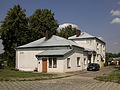
Small train station in Iłża

Pottery kiln in Iłża
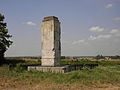
Monument in Pakosław
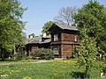
Manor in Prędocin


.jpg)
traffic
The state road DK9 ( Europastraße 371 ) runs through the municipality and its main town from north to south. It leads from the district town of Radom to Rzeszów , the capital of the Subcarpathian Voivodeship. The DW747 voivodship road leads from Iłża via Lipsko to Lublin .
The next train station is in the former district town of Starachowice to the south, another long-distance train station is also in Radom north of the municipality.
The nearest international airport is Warsaw , around 120 kilometers away.
Web links
- City and municipality website (Polish)
Individual evidence
- ↑ population. Size and Structure by Territorial Division. As of June 30, 2019. Główny Urząd Statystyczny (GUS) (PDF files; 0.99 MiB), accessed December 24, 2019 .
- ↑ a b regioset.pl: data on the municipality (Polish, accessed on May 27, 2020)
- ↑ Registered in the list of monuments of the Masovian Voivodeship under number 113 / A on June 26, 1981.
- ↑ Registered in the list of monuments of the Masovian Voivodeship under the numbers 823, 645, 71 / A / 82 of January 28, 1959, January 14, 1972 and March 5, 1981.
- ↑ Registered in the list of monuments of the Masovian Voivodeship under number 385 / A on May 15, 1988.
- ↑ Registered in the list of monuments of the Masovian Voivodeship under the number 477 / A on November 5, 1991.
- ↑ Registered in the list of monuments of the Masovian Voivodeship under the number 477 / A on November 5, 1991.
- ↑ Registered in the list of monuments of the Masovian Voivodeship under number 415 / A on January 30, 1990.
- ↑ Registered in the list of monuments of the Masovian Voivodeship under number 514 on December 4, 1957.
- ↑ Registered in the list of monuments of the Masovian Voivodeship under number 408 / A on May 8, 1989.
- ↑ Registered in the list of monuments of the Masovian Voivodeship under the number A-1244 on May 6, 2014.
- ↑ Registered in the list of monuments of the Masovian Voivodeship under number 517 on December 4, 1957.
- ↑ Registered in the list of monuments of the Masovian Voivodeship under number 382 / A on April 4, 1988.
- ↑ Registered in the list of monuments of the Masovian Voivodeship under number 516 on December 4, 1957.