Gračanica (Ljubovija)
|
Грачаница Gračanica |
||||
|
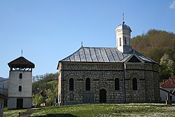
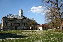
The Serbian Orthodox Ascension Church |
||||
|
||||
| Basic data | ||||
|---|---|---|---|---|
| State : | Serbia | |||
| Okrug : | Okrug Mačva | |||
| Opština : | Lyubovija | |||
| Coordinates : | 44 ° 29 ' N , 19 ° 23' E | |||
| Height : | 190 m. i. J. | |||
| Residents : | 371 (2011) | |||
| Telephone code : | (+381) 015 | |||
| License plate : | LO | |||
Gračanica ( Cyrillic : Грачаница) is a village in western Serbia , near the border with Bosnia and Herzegovina .
Geography and population
location
The village is located in the Ljubovija Opština , in the Okrug Mačva . Gračanica belongs to the historical Azbukovica region which is part of the Podrinje region . The Azbukovica Region includes the entire Ljubovija Opština.
The village consists of the hamlets : Aluga, Zakućani, Banovići, Đokići, Peći, Osoje, Brajkovac, Stepanovići, Nikolići and Đermanovići .
The neighboring villages of Gračanica are: Lonjin or Donja Ljuboviđa in the south , Uzovnica or Postenje in the north, Sokolac in the east , all three are in Serbia and belong to the same municipality as Gračanica, namely Ljubovija.
Only the western neighboring village on the other side of the Drina, Krasanovići, belongs to the Opština Bratunac in the Republika Srpska of Bosnia and Herzegovina.
Gračanica is located north of the municipal capital Ljubovija .
Waters
The river Drina flows west from the village over, it forms the border between Serbia and Bosnia and Herzegovina. The smaller rivers Gračanička Reka (also Gračanica), Sokolska Reka and Postenjska Reka also flow through the village . The source of the Gračanička Reka is located on the slopes of the Sokolska planina . The river flows through the hilly landscapes or ranges of hills of the Kutanj, Momić, Alijin Grm, Krst and Mikuljak where it flows into the Drina and together with it forms the western boundary of the village.
Many larger and smaller streams also flow through the village : Pelevića Potok, Gluščevački Potok, Duboki Potok, Đurića Potok, Purkovac, Ranovac, Mikuljački Potok, Paldin, Vesića Potok, Osojački Potok, Ajdarov Potok, Aluški Potokki Potok, Zakojevićućans, Spasojevićućans , Tartića Potok, Hadžića Potok, Sriđanski Potok, Atala, Bučanski Potok , Kuburovski Potok, Veleški Potok, Tušinski Potok, Gradinski Potok, Srećkovački Potok, Skenderovački Potok and Korićanski Potok .
There are several sources in the place with the following names: Topalova Voda, Mčjailova Voda, Studenac, Rotnica, Suljina Voda, Đokića Voda, Klen, Vesino Vrelo, Stipanovo Vrelo, Kapavac, Borovnata, Barakovača and Boškovača .
hill
The eastern border of the village extends from the source of the Bučanski Potok into the Gračanička Reka, over part of the course of the Sokolska Rijeka, over the Pećanska Kosa slope to the top of the Nikuljak hill . Nikuljak hill stands below Postenje and Kučevac mountains.
From the west the village is bordered by the Mikuljak and Karačica hills and the Drina. From the south the village is also bordered by the slopes of Mikuljak, as well as by the hills Savina Glavica, Alijin Grm and Banovići. Orlov Krš and Đokića Brdo border the north.
The individual hills of the hill chains in the village area have the following names: Đokića Brdo, Lokva, Vladinje, Donje Brdo, Bobija, Peći, Junuzovo Brdo, Tartića Gaj, Zelena Stijena, Aluga, Osoje, Rača, Šarampov, Slatina, Kovačevo Kućište, Glušci., Kućerina., Kućerina , Zoble, Stare Kuće, Sriđ, Kuburovina, Zelena Prljuša, Duga Stijena, Gradina, Skenderovina, Korita, Jastrebnjak, Kamenjača and Purkovača .
The fields in the village area bear the following field names : Luke, Kućerine, Kućišta, Lukavice, Lokva, Aluge, Bare and Močila .
population
The place had 371 inhabitants at the 2011 census, compared to 465 inhabitants in 2002. According to the last three population statistics, the number of inhabitants continues to fall. 100% of the population are Serbs . The place consists of 160 households.
Demographics
| year | population |
|---|---|
| 1948 | 990 |
| 1953 | 1160 |
| 1961 | 1096 |
| 1971 | 711 |
| 1981 | 630 |
| 1991 | 536 |
| 2002 | 465 |
| 2011 | 371 |
religion
The population of Gračanica professes the Serbian Orthodox Church . The Serbian Orthodox Church of the Ascension of Christ, built in 1903, is located in the village.
The church is the parish church of the Gračanica parish in the Azbukovica deanery of the Šabac eparchy of the Serbian Orthodox Church.
history
In Gračanica remains of a 4th century basilica have been found, which was destroyed by the Avars . This early Christian basilica stood roughly at the same place where the present-day Serbian Orthodox Church of the Ascension of Christ is located, namely on the Crkvine locality . Old graves have also been found in the place.
Already in the time of the Romans there were settlements in what is now the village area and open-cast mining was carried out in the village and lead was extracted. These old settlements and mines were found on the Mikuljak and Nikuljak hills, as well as the Brajkovac and Zakućani hamlets of the Gračanica village.
Some finds from the Middle Ages before the Ottomans, which prove a Serbian settlement of the village, have also been found.
From 1459, when the Ottomans conquered the Azbukovica region until 1862, there were three Muslim villages in what is now the village area: Aluge, Mala and Zakućani.
The village of Aluge was on the site of today's hamlet Aluge below the Momić hill on the way to the neighboring village of Donja Ljuboviđa. In 1820 Aluge owned 20 households and in 1832 23 households.
Zakućani was located below the hill Krst, south of the place where the church of the village is today and in 1832 owned 9 households.
Between Aluge and Zakućani below the Osoje hill was the third village of Mala, which in 1832 consisted of 22 households.
These three Muslim villages were under the protection of the Soko Grad fortress, which was then ruled by the Ottomans . In 1862 the three villages were dissolved and the residents moved to Bosnia or Turkey . The Serbian neighbors bought their land.
In the vicinity of Gračanica stands the medieval fortress Soko Grad (in German: Falkenstadt) founded by Serbs . The fortress, impregnable after the occupation by the Ottomans until 1862, was considered a terrible place of torture for the local Orthodox population. Today, near the remains of the fortress, there is the Serbian Orthodox Monastery of St. Nikolaj Srpski, consecrated to St. Nicholas of Ohrid and Žiča .
In 1930 the following Serbian families lived in the town: Banović, Vesić, Krsmanović, Nešković, Nikolić, Đukanović, Stepanović, Biljić, Stajić, Đermanović, Rakić, Spasojević, Živanović, Stanačić, Živanović, Milajutić, Marković, Bulovićović, Milajutinić, Bulovićović Jevtić, Janjić, Đokić, Vujinović, Savić, Radovanović, Sičić, Kovačević, Jovanović and Andrić . In 1930 the village consisted of 149 households. Some of the families live in the village for centuries.
In World War II, some died Tito - Partisans from the village in heavy fighting. A memorial plaque in the village center is dedicated to them.
Infrastructure
Gračanica is the seat of the local community (Mesna zajednica) Gračanica, to which the two neighboring villages Postenje and Sokolac also belong.
The village has the Petar Vragolić elementary school.
supporting documents
- Article about the village on the page poreklo.rs , (Serbian)
- Article about the fortress on the site Srbijanac.rs , (Serbian)
- Knjiga 9, Stanovništvo, uporedni pregled broja stanovnika 1948, 1953, 1961, 1971, 1981, 1991, 2002, podaci po naseljima, Republički zavod za statistiku, Beograd, maj 2004, ISBN 86-84433-14-9
- Knjiga 1, Stanovništvo, nacionalna ili etnička pripadnost, podaci po naseljima, Republički zavod za statistiku, Beograd, February 2003, ISBN 86-84433-00-9
- Knjiga 2, Stanovništvo, pol i starost, podaci po naseljima, Republički zavod za statistiku, Beograd, February 2003, ISBN 86-84433-01-7


