
Granary Burying Ground

The at in 1660 Tremont Street , founded Granary Burying Ground is the third-oldest cemetery of the city of Boston in the state of Massachusetts in the United States . Many famous people are buried there, including important fighters in the American Revolutionary War , three signatories of the United States Declaration of Independence , Paul Revere and five victims of the Boston massacre . There are a total of 2,345 graves in the cemetery, but historians suggest that at least 5,000 people were buried there. The Granary Burying Ground is adjacent to Park Street Church and across from Suffolk University Law School . The Granary Burying Ground is part of the Freedom Trail .
The entrance gate in the Egyptian Revival style and the fence surrounding the cemetery were designed by the Boston architect Isaiah Rogers (1810–1849), who had already developed an identical gate for the Touro Cemetery in Newport .
history

The Granary Burying Ground was established as the third cemetery in the city of Boston in 1660. The need for another cemetery arose from the fact that the area of the city's first cemetery - the King's Chapel Burying Ground located about a block further east - was no longer sufficient to cope with the growing population in Boston. Originally the name of the cemetery was South Burying Ground . This designation was 1737 Granary Burying Ground changed by the cemetery the name of the granary ( Granary Building accepted), which was located in what is now the Park Street Church stands. In May 1830, trees were planted on the site and an attempt was made to rename it Franklin Cemetery in honor of Benjamin Franklin's family , but it failed.
The Granary Burying Ground was originally part of Boston Common , which at the time comprised the entire block. However, two years after the cemetery was set up, the southwestern part of the Common was used for the construction of public buildings, including the granary and a House of Correction . The northern part of the block was used for the construction of residential houses.
At the beginning new graves were placed at the rear of the current property. On May 15, 1717, an application was approved to enlarge the cemetery and give up part of the highway on the eastern side (today's Tremont Street ). The expansion was implemented in 1720 when 15 new burial sites were created on the new section and assigned to a number of Boston families.
One of the most distinctive features of the cemetery was a row of large European elms that stood along Tremont Street that no longer exist. The trees were planted in 1762 by the then mayor of the city, Adino Paddock, together with John Ballard, and by 1856 had already reached 10 ft (3 m ) trunk circumference. The footpath below the elms was known as Paddock's Mall . However, the elms only shaded the entrance area of the cemetery, as there was not a single tree on the area. It was not until 1830 that more trees were planted across the site. In 1840, the cemetery was enclosed by an iron fence at a cost of $ 5,000 , half of which was borne by the city of Boston and half by donations. The architect Isaiah Rogers designed an identical entrance gate in the Egyptian Revival style for the Touro Cemetery in Newport .
In January 2009, a previously unknown crypt was discovered when a tourist suddenly broke through the ground during a self-guided tour of the cemetery. Below her a staircase emerged that led to a crypt. The entrance had only been closed with a slate of slate , which gave way due to age under the weight of the tourist. Fortunately, the tourist was unharmed and any remains were intact. The crypt is described as structurally intact and measuring 8 ft (2 m ) by 12 ft (4 m ). It is believed to contain the resting place of Jonathan Armitage, who was a Boston city councilor from 1732 to 1733 .
In May 2011, the city of Boston announced extensive $ 300,000 restoration work for the Granary Burying Ground. This also includes the widening of paths and the provision of new observation points. The Freedom Trail Foundation pays $ 125,000 for this , with the city taking over the remaining amount.
Memorials and monuments

In a prominent place in the cemetery is an obelisk from 1827, dedicated to the parents and loved ones of Benjamin Franklin, who was born in Boston and buried in Philadelphia . The granite of the obelisk comes from the same quarry as the one from which the Bunker Hill Monument was cut. Erected to replace the original Franklin family headstones, which were in very poor condition, the memorial was dedicated on June 15, 1827.
The oldest memorial in the cemetery is located near the obelisk and commemorates John Wakefield , who died on June 18, 1667 at the age of 52. Why there is a seven year gap between the inauguration of the cemetery and the oldest memorial is unknown. Near the entrance on Tremont Street are the cremated remains of the American victims of the Boston massacre that occurred on March 5, 1770.
During the 19th century, the tombstones were gradually moved in order to form exact rows according to the orderly understanding of the time. Another purpose was to simplify lawn mowing using modern equipment.
Graves of famous personalities
- John Phillips (1770–1823) - First Mayor of the City of Boston
- Samuel Adams (1722–1803) - statesman and signatory of the United States Declaration of Independence
- Crispus Attucks (1723–1770) - African American victim of the Boston massacre . In a mass grave with four other victims and a boy who was killed eleven days earlier.
- Peter Faneuil (1700–1743) - founder of Faneuil Hall
- Benjamin Franklin is a member of the family but not himself (Franklin is buried in Philadelphia , Pennsylvania ).
- Mary Goose (1665–1758) - Probably the real Mother Goose , but this is considered unlikely.
- Jeremiah Gridley (1702–1767) - Attorney at law
- John Hancock (1737–1793) - statesman and signatory of the United States Declaration of Independence
- James Otis Jr. (1725–1783) - lawyer and patriot in the American Revolutionary War
- Robert Treat Paine (1731-1814) - signatory of the United States Declaration of Independence
- Paul Revere (1735-1818) - silversmith and patriot in the American War of Independence
- Increase Sumner (1746–1799) - Third Governor of Massachusetts
- Nathan Webb (1705–1772) - Pastor of the first new Congregational Church in Massachusetts during the Great Awakening for over 41 years
- Benjamin Woodbridge (1708–1728) - victim of the first duel that was fought in Boston
- Samuel Sewall (1652–1730) - judge of the Salem witch trials
- John Smibert (1688–1751) - Scottish- American artist
- John Endecott (ca. 1588–1665) - First Governor of Massachusetts. His tombstone was destroyed over the years, and for a long time it was mistakenly believed that he was buried in King's Chapel Burying Ground . More recently, however, there was clear evidence that he was buried in grave number 189 on the Granary Burying Ground.
Picture gallery
Tomb of Samuel Adams .
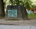
Grave of Crispus Attucks , Christopher Sider and other victims of the Boston massacre
Paul Revere's grave .

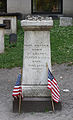
Grave of Increase Sumner , third and fifth governor of Massachusetts.

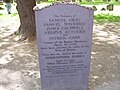
Grave of John Wheatley, owner of Phillis Wheatley .


See also
Individual evidence
- ^ A b David Abel: Colonial resting place slated for upgrade. $ 300,000 project planned for Granary. (No longer available online.) In: Boston.com. May 16, 2011, archived from the original on November 12, 2011 ; accessed on November 8, 2011 . Info: The archive link was inserted automatically and has not yet been checked. Please check the original and archive link according to the instructions and then remove this notice.
- ↑ a b James Stevens Curl: The Egyptian Revival . Routledge, London 2005, ISBN 978-0-203-01195-9 , pp. 300 .
- ^ D. Brenton Simons: Boston beheld . antique town and country views. University Press of New England, Hanover, Boston 2008, ISBN 978-1-58465-740-8 ( full text in Google Book Search).
- ↑ Shurtleff , p. 211
- ^ Thomas Bridgman, The Pilgrims of Boston and their descendants . D. Appleton and Co., New York 1856 ( online in Google Book Search).
- ↑ Shurtleff , p. 216
- ↑ Andrew Ryan, John R. Ellement: Burying ground yields a secret. Tourist's misstep reveals unknown Granary crypt. In: Boston.com. February 12, 2009, accessed on November 9, 2011 (English, including video).
- ↑ Shurtleff , p. 219
- ↑ Granary. In: CityOfBoston.gov. Retrieved November 9, 2011 .
- ↑ Joel Benton: MOTHER GOOSE .; Longevity of the Boston Myth. (PDF) The Facts of History in this Matter. In: The New York Times. February 4, 1899, accessed November 9, 2011 .
- ↑ Shurtleff , p. 222
Monographs
- Nathaniel Bradstreet Shurtleff: A topographical and historical description of Boston . Printed by request of the City Council, Boston 1871, OCLC 4422090 , p. 210–226 ( online in Google Book Search).
Web links
Coordinates: 42 ° 21 '26.5 " N , 71 ° 3' 41.9" W.
| Official stations |
Boston Common • Massachusetts State House • Park Street Church • Granary Burying Ground • King's Chapel • King's Chapel Burying Ground • Benjamin Franklin Statue • Boston Latin School • Old Corner Bookstore • Old South Meeting House • Old State House • Scene of the Boston Massacre • Faneuil Hall • Paul Revere House • Old North Church • Copp's Hill Burying Ground • USS Constitution • Bunker Hill Monument |
|
| Unofficial stations |
Boston Navy Yard • Breed's Hill • Charlestown Bridge • Dock Square • Hanover Street • New England Holocaust Memorial • North Square • Pie Alley • Quincy Market • School Street • Union Street |