Lübeck-Schlutup border documentation center
The Lübeck-Schlutup Border Documentation Center (own name: Grenzdokumentations-Stätte Lübeck-Schlutup e.V. ) is a memorial to the time of the division of Germany at Mecklenburger Straße 12 in the Schlutup district of the Hanseatic city of Lübeck .
location
The building was on the former, subsequently relocated Bundesstraße 104 . Schlutup and its border documentation center can only be reached via the exit from the bypass road (new route of federal highway 104). The building is on Mecklenburger Strasse.
The documentation center is located on the former inner-German border between Schleswig-Holstein and Mecklenburg-Western Pomerania in a former customs building that belonged to the Schlutup border crossing on the West German side. It was the northernmost border crossing between the Federal Republic and the GDR . The border crossing was used for transit traffic via the ports of Rostock and Rügen to Scandinavia, as an entrance to the VEB Landfill Schönberg , for small border traffic and general entry and exit into the GDR. The corresponding east German border building was demolished after 1989.
Today the documentation center can also be reached via the Iron Curtain Trail , which is Europe's longest long-distance cycle route along the former Iron Curtain from Norway to the Black Sea.
history
The documentation center is supported by the Friends of the Grenzdokumentations-Stätte Lübeck-Schlutup eV , the city of Lübeck provided the building purchased by the federal government in 1999 and bears the ancillary costs. Initially, the establishment of a Lübeck border museum under municipal sponsorship was discussed in Lübeck. The city moved away from this in 1999 for cost reasons. In the same year citizens joined together under the name Förderverein Grenzmuseum. One of the initiators was Ingrid Schatz (CDU), member of the Lübeck parliament. After years of vacancy, the building was renovated. Steel constructions came to light under the wall cladding, which should make the building bug-proof. The documentation center was opened on November 9, 2004.
exhibition
ground floor
With photos, maps, documents, uniforms of customs and border officials of the Federal Border Police and the GDR as well as other exhibits, the situation of Lübeck and especially Schlutup during the time of division is presented. Photos from the days of the opening of the border and pictures of Schlutup and neighboring Selmsdorf are shown in the corridor behind the offices . A copy of the order to fire also documents the requirements for firing fatal shots without a warning shot. The boundary between Priwall , Pötenitzer Wiek , Dassower See , Trave and Schlutuper Wiek is recorded in a relief model. GDR medals, a check-in counter, signs "No entry" and collapsible field telephones are shown. It reports on the fate of the people who were affected by the forced relocations of the Vermin campaign in Mecklenburg from 1952 onwards . Requests to leave the country and notes in ID cards make the isolation of the former GDR citizens imaginable. One of the exhibits is a rubber dinghy with which doctors from Greifswald fled to the west across the Baltic Sea. The former detention room remained unchanged .
Basement
A documentary film is shown in the basement, which also contains footage from Schlutup and Lübeck after the border was opened in 1989. There is also a library there .
Special exhibitions
The building is used for special exhibitions, around 2006 for a traveling exhibition under the title “ Stasi in the Baltic Sea Region” and for lectures in cooperation with the Rostock branch of the BStU . In 2009, on the 20th anniversary of the opening of the border , the temporary installation Rigidity by the artist Renate U. Schürmeyer was set up in front of the Documentation Center .
Surroundings of the building
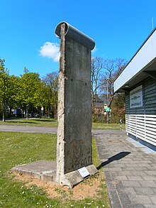
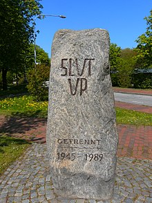
In front of the terminal building there is an original segment of the Berlin Wall , the segment of a border fence with a plaque for Harry Weltzin and a Trabant car to commemorate that time. About 200 meters away on Mecklenburger Straße, a memorial stone with the Low German appeal Slut up reminds of the division. Before the opening of the border, vigils for reunification were held at this stone .
See also
Another exhibition about the former inner-German border is located in Lübeck in the Federal Police Academy .
Web links
- Website of the Lübeck-Schlutup border documentation center
- The border documentation center on the side of the Hanseatic City of Lübeck
Individual evidence
- ^ Website of the Lübeck-Schlutup border documentation point
- ↑ Iron Curtain Trail - Through Germany. (No longer available online.) Archived from the original on April 16, 2017 ; accessed on April 15, 2017 . Info: The archive link was inserted automatically and has not yet been checked. Please check the original and archive link according to the instructions and then remove this notice.
- ↑ Museum has no chance . In: Lübeck city newspaper . March 7, 2000 ( online [accessed July 19, 2016]).
- ^ Lübecker Chronik In: Lübeckische Blätter . 165th year, issue 15
- ↑ People on the Other Side, October 5, 2006
- ^ Chronicle of Schlutup
- ^ Lecture and exhibition in the Grenzmuseum Schlutup In: HL-live from September 28, 2006
- ↑ Sabine Spatzek: Over there, where the world ended . In: Kiel News . September 2, 2009 ( online [accessed July 19, 2016]).
- ↑ Alexander Steenbeck: Federal Police shows their treasures shz.de, March 21, 2014, accessed on May 7, 2020
Coordinates: 53 ° 53 ′ 3.1 ″ N , 10 ° 48 ′ 18.9 ″ E


