Grivola
| Grivola | ||
|---|---|---|
|
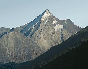
The Grivola seen from the northwest, on the right the Pointe Tuckett |
||
| height | 3969 m slm | |
| location | Aosta Valley , Italy | |
| Mountains | Graian Alps | |
| Coordinates | 45 ° 35 '44 " N , 7 ° 15' 39" E | |
|
|
||
| rock | Orthogneiss | |
| First ascent | August 28, 1861 by PB Chamonin and AJ Jeantet from Cogne | |
| Normal way | through the southeast wall | |
| particularities | Second highest peak in the Graian Alps (without the Mont Blanc group ) | |
The Grivola is with a height of 3969 meters, the second highest mountain in the Graian Alps , a mountain range in the western Alps . It is located in the Italian region of Aosta Valley and is part of the Gran Paradiso National Park . Viewed from the north, the Grivola appears as a symmetrically shaped rock pyramid, which sends distinctive, evenly curved ridges to the northeast, south and west. The Italian poet Giosuè Carducci called them l'ardua Grivola bella ( the strenuous beautiful Grivola ) because of the long walks . The word Grivola means in the Occitan language young girl . The mountain was first climbed on August 28, 1861 by the priest Pierre-Balthazar Chamonin and the mountain guide AJ Jeantet from Cogne to the east .
geology
The north side of the Grivola consists of orthogneiss , a rock that is typical for the area , a solid gneiss formed by magmatic influences that forms scale-like plates here and enables friction climbing. On the other hand, its south side is made up of extremely brittle metamorphic crystalline sedimentary rock , which consists mainly of limestone and mica schist . These rocks come from the Penninic , the deposit zone of the Tethys Ocean , which existed in the Mesozoic era in what is now the Alpine region.
Surroundings
The Grivola is surrounded by glaciers in the north and east . In the northwest lies the Belleface Glacier, in the northeast the Nomenon Glacier stretches up to an altitude of 3667 meters. Finally, to the east, the extensive Trajo Glacier extends. Neighboring mountains along the south ridge are initially the 3,804 meter high Pointe Tuckett (named after the English mountaineer Francis Fox Tuckett ), then beyond the Col de la Grivola pass (3,738 m), the 3,793 meter high Pointe Blanche . The Gran Paradiso (4061 m) is located on the Graian main ridge, which runs south, about eight and a half kilometers away. North of the Grivola, separated by the Col des Cochette (3477 m), lies the 3514 meter high Grivoletta . To the west, the area drops into the north-south running Valsavarenche valley, to the northeast into the Cogne valley and to the southeast into Valnontey . The closest significant places to the west are the village of Valsavarenche, just under four kilometers as the crow flies , and the municipality of Cogne is eight kilometers to the east.
Base and ascent
The first attempt to climb the Grivola documented in literature was made in 1859 by the English tourists Francis Fox Tuckett , J. Ormsby and R. Bruce, as well as the royal Sardinian-Piedmontese game warden Fidèle-Ambroise Dayné from Cogne with the mountain guides E. Cachat and Jean Tairraz took place from the western town of Valsavarenche via a path that is no longer used today , but did not lead to success. The route over the south ridge is also avoided. Today's normal route , the easiest ascent, leads through the generally not so brittle south-east face through well-graded terrain. The difficulty does not exceed UIAA grade II or PD ( peu difficile ) . The Sella refuge serves as a base , located at an altitude of 2584 meters west of the small settlement of Valnontey. Closer to the Grivola is the nine-person Gratton bivouac box (3280 m). The way to the summit of the Grivola leads as a high tour over the crevasse Trajo glacier. The walking time is four hours from the bivouac box and six hours from the hut. Since 1872 there has also been an ascent over the northeast ridge, which requires climbing skills up to UIAA grade III +.
Literature and map
- Gerd Klotz: Gran Paradiso area guide , Bergverlag Rother , Munich 2005, ISBN 3-7633-2407-0
- Instituto Geografico Centrale, Turin, hiking map 1: 25,000, sheet 101, Gran Paradiso, La Grivola, Cogne

