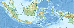
Great Sunda Islands
| Great Sunda Islands | ||
|---|---|---|
| Great Sunda Islands | ||
| Waters | Indian Ocean , Pacific Ocean | |
| archipelago | Sunda Islands , Malay Archipelago | |
| Geographical location | 7 ° 30 ′ S , 111 ° 15 ′ E | |
|
|
||
| Number of islands | 4 very large islands | |
| Main island | Java | |
| Total land area | 1,500,000 km² | |
| Residents | 180,000,000 | |
The Great Sunda Islands are a group of islands in the Malay Archipelago . Together with the Lesser Sunda Islands , they form the Sunda Islands .
Concept and delimitation
In a narrower sense, only the four largest islands are included:
- Sumatra
- Java
- Borneo ( Indonesian Kalimantan)
- Sulawesi (formerly: Celebes)
With 1.5 million km² and around 180 million inhabitants, it is the largest group of islands in the world (only Greenland is larger in area).
Besides the north of Borneo, the islands form the main part of Indonesia . East Malaysia and Brunei are located on Borneo .
In a broader sense, the upstream and intervening smaller islands are also included, in total there are several hundred.
The southern of the islands form the border between the Indian Ocean and the Pacific Ocean . The Java Sea as part of the Australasian Mediterranean Sea is already part of the Pacific, as is the South China Sea in the north.
Smaller islands
There are many small islands and archipelagos around the main islands of the Great Sunda Islands. This includes:
At Sumatra:
- Bengkalis , Rupat and Padang off the northeast coast
- Riau Islands further to the east
- Lingga Islands south of the Riau Islands
- Anambas Islands further to the northeast, in the South China Sea
- Nias , Siberut and Simeuluë off the southwest coast
- Krakatau archipelago between Sumatra and Java
Near Borneo:
- Natuna Islands : in the northwest, in the South China Sea
For Java:
Near Sulawesi:

