
Digging swat
| Digging swat | |||
|---|---|---|---|
| General information about the mine | |||
 |
|||
| Information about the mining company | |||
| End of operation | 1866 | ||
| Funded raw materials | |||
| Degradation of | Iron ore | ||
| Geographical location | |||
| Coordinates | 48 ° 59 '6.7 " N , 11 ° 5' 6.8" E | ||
|
|||
| Location | Raitenbuch Forest | ||
| local community | Raitenbuch | ||
| country | Free State of Bavaria | ||
| Country | Germany | ||

The Grubschwart is a cave system in the southern part of the Franconian Jura that was opened up and modified by mining activities in the 19th century .
geography
The Grubschwart is located in the Raitenbucher Forest in the Middle Franconian district of Weißenburg-Gunzenhausen in Bavaria . It is located about 4.4 kilometers southwest of the municipality of Raitenbuch and 2.7 kilometers northeast of Rothenstein , a district of the city of Weißenburg .
geology
In the Mesozoic , around 200 to 150 million years ago, the so-called Jurassic Sea was located there . The fossil-rich gryphae sandstone formation interlocks with lime-rich deposits that were created by the once mighty offshore coral reefs . The rivers transported dissolved iron oxides to the estuary. The iron was precipitated there and sank to the ground. Over the course of millions of years, superimposed layers were deposited. By the plate tectonics of continental drift the embedded spherical came Doggererze ( bean ore ) later far above the sea level and were erosion minded close to the earth's surface. Floor ore are between 1.5 and 5 centimeters in size and often grown together into lumps. They have a bean-like shape from which the name floor ore originates and makes them distinguishable from the lawn iron ores that were first created during the Ice Age . Their iron content in this deposit is around 34 to 30 percent. The ores were also deposited in the clay fillings of an extensive karst system .
history
Exactly when ore mining began there has not yet been fully explored. Iron ore was mined in the old mining area for at least 2000 years until 1866. The earliest evidence of local iron mining was provided by archeology through finds from smelting sites from different epochs. These show that there was already before the Latène period , around 500 BC. Ore was mined. Around the mining area there is a striking number of unadorned burial places from the Hallstatt period , which suggests that the hard and dangerous mining and smelting work claimed many victims. The mining sites and burial sites are protected as ground monuments.
Since the Roman road from Weißenburg to Pfünz , which ran just two kilometers to the east, the Romans certainly knew about these mineral resources. These also opened up the marble quarries to the west, a building material with which they were already very familiar. The north bend in the Limes near Kaldorf is justified with the capture of these mining areas.
The first written evidence of the dismantling comes from the year 1411, when the steelworks office in Obereichstätt was founded. In 1469 an ore wash was first mentioned in writing. The name Grubschwart can be found around 1500 as "Kropfschwarden" in written records. The word means a overgrown with grass Brachfeld in a pit. Goiter refers to the pit itself.
In the mining area of Grubschwart, floor ore and kitterze were the target of the miners and Steiger. Mining has long been a winter seasonal business for farmers in the area. The directly adjacent hollow hole was also used as a medieval burial place, the location, which is unusually remote for the burial culture of this epoch, was probably a plague pit . (D-5-7032-0059)

The above-ground mine was continuously expanded around 1783 by underground mining . The shaft, which is about 150 meters away from the entrance, was documented in writing by a survey in 1806. In 1814 the mine shaft was mentioned again. From this shaft, further tunnels were driven into the mountain in an easterly direction and the rear, cave-like part of the facility was opened up. Until it was closed in 1866, this was the logistical center of the “Grubschwart” mining district, which at times included several other mines. In the 20th century, undiscovered ore deposits were searched for again. For this purpose, an approximately 100 meter long, dead straight prospecting gallery was driven into the massive stone. However, the attempt was unsuccessful and nature reclaimed the area. In 2010 the area was completely removed from forest management and placed under protection.

Description and today's access
The traces of ore mining in the area are still partially visible. Funnel pits ( pinging ), mine shafts and tunnels are reminiscent of the former iron ore mining . Two mine tunnel entrances, a hole in the former mining shaft and numerous pings are still clearly visible today. In addition to the outlines of an old Steigerhaus , the spoil heaps and the open pit fields also bear witness to the long mining tradition. At the end of mining in 1861, the length of the tunnel was over 1000 meters.
The area is designated as a geotope (577G001) by the Bavarian State Office for the Environment and a soil monument (D-5-7032-0060, D-5-7032-0061) by the Bavarian State Office for Monument Preservation . In the cave register Fränkische Alb (HFA) the two tunnel entrances are listed as K 10 and K 10a . Part of this system is a multi- room cave system , which was almost completely filled with sediments containing coal ore .
The tunnel entrances were closed with grille doors in 2012. The northern tunnel entrance is a blind tunnel and collapses after about 50 meters. The area is freely accessible all year round. In 2012, the 3.5 kilometer long mining history educational trail Grubschwart was opened. An overview board and 20 themed boards inform visitors about the raw material iron ore, its extraction and smelting and the hard work of the miners.
The tunnels themselves are closed with grids and can no longer be driven on. The closure was carried out in addition to safety concerns due to the cave protection and especially to protect the bats .
The educational trail was created on the initiative of the mining historian and book author Arthur Rosenbauer from Treuchtlingen . He researched and documented the forgotten mining industry in the region with his book "Forgotten Secrets Rediscovered", published by WEK Verlag in 2010. Bayerischer Rundfunk also reported on its activities .
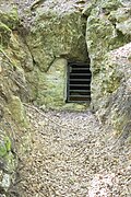
Entrance to the blind gallery

The gallery from the inside near the entrance

Digging pit (pinge)

View of the former production shaft

Hole of the conveyor shaft

Spoil dump


literature
- Arthur Rosenbauer: Caves, grottos and sinkholes - a fascinating world underground . Wek-Verlag, Treuchtlingen / Berlin 2013, ISBN 978-3-934145-87-0 , pp. 119-143.
- Martin Trappe: The mine-cave system Grubschwart (K 10) . In: Karst und Höhle 2008–2010 - Southern Franconian Alb region Altmühl- and Danube Valley . Published by the Association of German Cave and Karst Researchers e. V., Lambach Druck und Verlag, Munich 2010, ISSN 0342-2062 , pp. 120–127.
Individual evidence
- ↑ a b c d LfD list for Raitenbuch. Pages 6–8 (.pdf)
- ↑ Caveseekers: Grubschwart Stollen (accessed September 1, 2015)
- ↑ LfU, Geotop 577G001 (accessed on September 1, 2015)
- ↑ GeoLehrpfade in Bayern, Montangeschichtlicher Lehrpfad Grubschwart (accessed on September 1, 2015)
- ↑ Course of the empty path in OpenStreetMap (accessed on September 1, 2015)
- ^ Homepage of WEK Verlag
- ↑ Arthur Rosenbauer; Forgotten secrets - rediscovered. Mining in the Altmühltal Nature Park between Altmühl, Anlauter and Danube ; wek-Verlag: Treuchtlingen / Berlin 2010; ISBN 978-3-934145-81-8
- ^ BR, Between Spessart and Karwendel, Arthur Rosenbauer ore of the Celts from minute 30
Information boards on site, see pictures in Commons