
Gyulakeszi
| Gyulakeszi | |||||
|
|||||
| Basic data | |||||
|---|---|---|---|---|---|
| State : | Hungary | ||||
| Region : | Central Transdanubia | ||||
| County : | Veszprém | ||||
| Small area until December 31, 2012 : | Tapolca | ||||
| District since 1.1.2013 : | Tapolca | ||||
| Coordinates : | 46 ° 52 ' N , 17 ° 29' E | ||||
| Area : | 9.67 km² | ||||
| Residents : | 709 (Jan. 1, 2011) | ||||
| Population density : | 73 inhabitants per km² | ||||
| Telephone code : | (+36) 87 | ||||
| Postal code : | 8286 | ||||
| KSH kódja: | 09520 | ||||
| Structure and administration (status: 2018) | |||||
| Community type : | local community | ||||
| Mayoress : | Veronika Szennyainé Kovács (independent) | ||||
| Postal address : | Kossuth Lajos u. 55 8286 Gyulakeszi |
||||
| Website : | |||||
| (Source: A Magyar Köztársaság helységnévkönyve 2011. január 1st at Központi statisztikai hivatal ) | |||||


Gyulakeszi is a Hungarian community in the district Tapolca in Veszprém County .
Geographical location
Gyulakeszi is a good three kilometers southeast of the town of Tapolca at the foot of the Csobánc mountain . Neighboring communities are Káptalantóti, Nemesgulács and Kékkút .
Attractions
- Castle ruins, located on the Csobánc mountain
- László-Gyulaffy bust ( Gyulaffy László-mellszobor )
-
Roman Catholic Church Kisboldogasszony , built in the mid-18th century (Baroque)
- Crucifix, to the left of the church, from 1853
- Roman Catholic Chapel Szent Donát , located in the vineyards
- Szentháromság Statue ( Szentháromság-szobor ), erected in 1910
- World War Memorial ( I. és II. Világháborús emlékmű ), in the garden of the church
traffic
Roads No. 7313 and No. 7316 meet in Gyulakeszi. The nearest train stations are in Tapolca and Nemesgulács-Kisapáti.
photos

Roman Catholic Kisboldogasszony Church

crucifix

Szentháromság statue
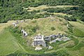
View of the castle ruins

Castle ruins

Memorial plaque in the castle ruins


.jpg)

literature
- Gyulakeszi - Településképi Arculati Kézikönyv 2017. Ed. By the municipal administration, Gyulakeszi 2017.
Web links
- Official website ( Hungarian )
- Gyulakeszi in A Pallas nagy lexikona (Hungarian)
- Gyulakeszi at tourinform