
Szigliget
| Szigliget | |||||
|
|||||
| Basic data | |||||
|---|---|---|---|---|---|
| State : | Hungary | ||||
| Region : | Central Transdanubia | ||||
| County : | Veszprém | ||||
| Small area until December 31, 2012 : | Tapolca | ||||
| Coordinates : | 46 ° 48 ' N , 17 ° 26' E | ||||
| Area : | 34.26 km² | ||||
| Residents : | 817 (Jan. 1, 2011) | ||||
| Population density : | 24 inhabitants per km² | ||||
| Telephone code : | (+36) 87 | ||||
| Postal code : | 8264 | ||||
| KSH kódja: | 24891 | ||||
| Structure and administration (as of 2016) | |||||
| Community type : | local community | ||||
| Mayor : | Balázs Balassa (independent) | ||||
| Postal address : | Kossuth et al. 54 8264 Szigliget |
||||
| Website : | |||||
| (Source: A Magyar Köztársaság helységnévkönyve 2011. január 1st at Központi statisztikai hivatal ) | |||||


Szigliget [ ˈsiɡliɡɛt ] is a municipality on the northern shore of Lake Balaton in Veszprém County in Hungary .
Geographical location
Szigliget is located in Transdanubia on the shores of Lake Balaton . The municipality is located 18 km east of Keszthely and 10 km west of Badacsony . The village is located on a peninsula surrounded by countless volcanic hills. The peninsula was an island a long time ago and only accessible by boat. In the nineteenth century, an important water regulation was carried out in Central Transdanubia in Hungary, during which the Balaton drained and as a result the island of Szigliget became a peninsula.
history
Because of the protected and closed location of the village, people settled here a long time ago. Archaeological finds indicate that this area was already inhabited in the Stone Age and the Bronze Age. Celtic, Roman and Avar grave finds prove the constant presence of man in this area. Szigliget also has a medieval castle ruin that sits enthroned on a 239 meter high mountain.
Town twinning
gallery
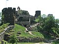
Szigliget castle ruins

Gun on the castle ruins of Szigliget

Esterházy Palace, former Esterházy Palace , today a writer's home

Ruins of the church of Avas (13th century)


_9.jpg)

