Höhbeck (mountain)

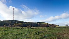
The Höhbeck is a mountain in the northeast of Lower Saxony that is up to 76 meters above sea level . The 2 × 4 kilometer elevation is a geest island in the glacial valley of the Elbe , which towers over the surrounding landscape by around 60 meters. The Höhbeck is located in the municipality of Höhbeck within the Lüchow-Dannenberg district and is located in the Lower Saxony Elbe Valley Biosphere Reserve .
geography

With its elevated position, the Höhbeck protrudes from the surrounding area like an island and represents a landmark . On the north and east side, the shifting of the Elbe created a steep bank, the slopes of which are covered with forest. The elevation is flat on the west and south sides. Aeolian agitated sand is characteristic, partly with heavy drift sand . At the highest point of the Höhbeck is the 344 meter high radio tower of the Höhbeck transmitter . The villages such as Brünkendorf , Pevestorf and Vietze are located on the elevation of the Höhbeck or on its edge in a flood-proof area. To the west and south of the Höhbeck is the approximately 3 km long and only 150 meters wide Laascher See . In the south lies the equally narrow Restorfer See .
geology

The Höhbeck is largely a compression terminal moraine that was formed during the first Drenthe stage of the Saale Ice Age around 230,000 years ago. In some areas, such as Brünkendorf, there are even older sediments from the Tertiary and the Elster Ice Age . The Höhbeck was probably separated from the Geest by the erosion of the Ur-Elbe during the Vistula Ice Age , which formed the Elbe Valley through meltwater . This created the Geestinsel des Höhbeck as a striking slab . It is made up of Pleistocene gravel, sand and boulder clay and lies within the Holocene Elbe valley lowlands. Until the prehistoric times, the Höhbeck was a river island around which the Elbe and Seege rivers as the former Elbarm.
Floors
On the Höhbeck predominates among the soil types , the brown earth . Likewise come Podsol - and Rankerböden before in various forms. Pseudogleye rarely occurs. In some areas there are extremely poor soils that are no longer in use today and only have up to 20 soil points.
colonization
The first settlement activities on the Höhbeck can be traced back to the Paleolithic . The elevation was a settlement chamber that was used intensively as a settlement and burial site from the Neolithic to the Early Iron Age . This was shown by excavations of the Lower Saxony State Museum on the Pevestorf site in the 1960s. The origins of the villages of Brünkendorf and Pevestorf are attributed to the Elbe-Germanic tribe of the Longobards . Slavic settlements can also be identified on and on the Höhbeck, such as the deserts of Klein Pevestorf and Klein Vietze. The places Vire and Terzichow are mentioned as further devastation in medieval documents.
Fortifications

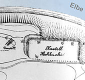
Two historical fortifications are known on the Höhbeck, which were castle walls that were built at a strategically favorable location on the steep slope facing the Elbe. It is about the Vietzer Schanze , which is regarded as the Höhbeck fort (castellum hohbuoki) of the Franks, which was handed down in the Franconian annals in 811 ; it rises about 30 m above the Elbe valley. Another rampart on the Höhbeck is the Schwedenschanze, 800 m away, from the 8th to 9th centuries, which rises almost 50 m above the river valley.
Flora and fauna
Due to its biogeographical location in the transition between the Atlantic and the continental region of Central Europe, the Höhbeck has a particularly large variety of flora and fauna . There are numerous animal and plant species on the Red List as well as nationally and internationally protected species, plant communities and biotope types . Lean and sandy dry grass form a diverse contrast with forests, fields and the water-rich lowlands of the Elbe and the Seege tributary. The occurrence of the peregrine falcon and the barnacle warbler are special. The occurrence of the fire-bellied toad , sand lizard and numerous bat species is also significant .

The landscape of the Höhbeck has long been designed and changed by man. In today's vegetation there are still remnants of the earlier cultural landscape and its economic forms. These include relics of heather , dry grassland , coppice and oak-hornbeam forests .
According to a map from 1695, the Höhbeck was almost free of forests at that time. Its surface is described as "sandy pastures, sand fields, unusable sand fields and meets". A map of the Kurhannoversche Landesaufnahme from 1776 shows various open areas known as "Heidehügel". It was drifting sand dunes that were used for agricultural purposes with dry grass, bristle grass and dwarf shrub heaths . Around 100 years later, most of the Höhbeck is still shown as an open landscape on a map from 1881.
literature
- Hartmut Christier: The Höhbeck: vegetation, faunistic and biogeographical significance of a glacial Geest island in the middle Elbe valley. Hamburg 2008, dissertation ( online , 7.2 MB)
- Jens Schneeweiß: Archaeological highlights from Höhbeck. Höhbeck-Brünkendorf 2010, ISBN 978-3-00-031553-4 , (Book title: Online )
Web links
Coordinates: 53 ° 4 ′ N , 11 ° 26 ′ E
