Hüttensteinach
|
Hüttensteinach
City of Sonneberg
Coordinates: 50 ° 21 ′ 50 ″ N , 11 ° 12 ′ 27 ″ E
|
||
|---|---|---|
| Height : | 460 m above sea level NN | |
| Incorporation : | April 1, 1923 | |
| Incorporated into: | Köppelsdorf | |
| Postal code : | 96515 | |
| Area code : | 03675 | |
|
Location of Hüttensteinach in Thuringia |
||
|
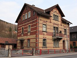
Residential and commercial building from 1903
|
||
Hüttensteinach is a district of the city of Sonneberg in Thuringia .
location
Hüttensteinach is a place in the southern Franconian Forest . The village is connected to Sonneberg and the surrounding area via state road 1150 and district road 31. Hüttensteinach is also located on the Coburg – Ernstthal am Rennsteig railway line and is connected to the STB 41 ( South Thuringia Railway ) line via the Sonneberg (Thür) Nord stop .
history
The first documentary mention was made on April 13, 1464. Hüttensteinach was on a side branch of the "old military and trade route" that connected Nuremberg and Leipzig . The deep and narrow valley floor running in north-south direction was unsuitable for agricultural purposes, but the iron and copper ore extracted in the adjacent mountains formed the basis of a mining industry that had flourished since the 15th century, for which smelters and hammer mills were also required. Therefore, a princely licensed hammer mill formed the origin of the place, this was in the northern part of the current location, which extends over a total of about one kilometer along the main road, the railway line and the Steinach river . The houses of the miners, ironworkers and charcoal burners quickly enlarged the place.
The Jüdenbacher Straße, with an infirmary that was known 200 years ago, now forms the core of Hüttensteinach's location. The elongated district "Hüttengrund" was the third part of the settlement. With the sheet metal hammer, upper and lower hammer mills and sawmills, halfway to Steinach, it was temporarily incorporated into Hüttensteinach.
By introducing the Saiger technology in the smelting of copper ores, the profitability of the mining companies could be significantly improved, but considerable start-up capital was required to build a Saigerhütte , which in the case of the Hüttensteinacher Saigerhütte was provided by Nuremberg investors. The mining files record frequent changes of ownership and alterations, mostly the previous owners' debts may have contributed to the ruin of the mining industry, and at times the hammer mill was used again for iron forging. During the Thirty Years War the place was raided and plundered several times, the few inhabitants hid in the dense forests and ravines. Around 1660 the von Erffa family ( Unterlinder branch) owned the iron hammer and began to rebuild the facilities. Further changes of ownership took place in 1681, 1690 and 1698. In Hüttengrund there were also two tin hammers, grinding and cutting mills and a foundry known as the “Zinnhaus”. The factories owned by the Baumann family produced 4,000 quintals of iron a year, and bars, sheets and other blanks were forged from them as required. According to Georg Brückner , the iron goods were sold through the Frankfurt am Main trading center to Holland . The owners, which also changed frequently in the 19th century, finally prove the permanent decline of Hüttensteinach's mining tradition.
In 1840 and 1851, floods caused by the sudden onset of a thaw caused severe damage in Hüttengrund. The porcelain factory Swaine & Co. was established in 1854 and Gebr. Schoenau in 1864. In 1886 the railway line from Sonneberg to Lauscha was opened, which shifted the movement of goods from the road to the tracks. Hüttensteinach developed into an industrial location.
On April 1, 1923 Steinbach was incorporated into Köppelsdorf. On July 1, 1950, Köppelsdorf became a district of Sonneberg.
Porcelain production ended in 1974. In 2011 there are still a few craft businesses in the village.
Personalities
- Richard Müller-Uri (1859–1929), glass blower and instrument maker
- Walter Franck (1896–1961), stage and film actor
- Fred Delmare (1922–2009), actor
dialect
Itzgründisch is spoken in Hüttensteinach . This is a Main Franconian dialect.
Individual evidence
- ^ Heinz Späth: Geographical Land Survey: The natural spatial units on sheet 141 Coburg. Federal Institute for Regional Studies, Bad Godesberg 1987. → Online map (PDF; 5 MB)
- ^ Wolfgang Kahl : First mention of Thuringian towns and villages. A manual. 5th, improved and considerably enlarged edition. Rockstuhl, Bad Langensalza 2010, ISBN 978-3-86777-202-0 , p. 131.
- ^ Georg Brückner : Regional studies of the Duchy of Meiningen. Part 2: The topography of the country. Brückner and Renner, Meinigen 1853, pp. 468–469 .
literature
- Peter Lange: Saigerhütten in Thuringia. Inside: Saigerhütte Hüttensteinach. In: copper silver steel. Contributions to the history of metallurgy. Museums of the City of Olbernhau, Olbernhau 1988, p. 19.
- Hüttensteinach. In: Paul Lehfeldt : Building and Art Monuments of Thuringia. Duchy of Saxony-Meiningen. Volume 3: Sonneberg District. District court districts of Sonneberg, Steinach and Schalkau. Gustav Fischer, Jena 1899, p. 8 .


