
Hōju-ji


The Hōju-ji ( Japanese 宝 壽 寺 ) with the Go Tenyōzan (天 養 山) and Kanonin (観 音 院) is a temple of the Shingon direction of Buddhism in the city of Saijō ( Ehime Prefecture ). In the north it borders directly on the Yosan Line near the Iyo Komatsu station, in the south on National Road 11 . In the traditional count, it is the 62nd temple on the Shikoku pilgrimage route .
history
According to tradition, the temple was built at the behest of the emperor Shōmu in the first half of the 8th century, when he wanted a temple in "every province" (諸国 一 宮; Shoku ichi no mmiya). At that time the temple was called Kongōhō-ji (金剛 宝 寺). Priest Kūkai later came here during the Taidō era (806-810) and donated a self-made eleven-headed Kannon to the temple. The temple was given its current name, Hōju-ji. The temple suffered frequent damage from the nearby Nakagawa River, but was restored in 1145.
The temple continued to flourish, now belonging to the Ōyamazumi-jinja (大 山 祇 神社), until it was reduced to rubble during the conquest of Shikoku by Toyotomi Hideyoshi . In 1636 the temple was rebuilt at its current location by the pilgrim priest Yūden (宥 伝). After the Meiji Restoration , it was dissolved as part of the separation of Buddhism and Shintoism, but was rebuilt in 1887.
When the Yosan railway line was passed here in 1921, the temple was moved 100 meters further west. And when National Road 11 was expanded, the southern part of the temple area was lost.
The attachment
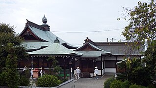
The small temple has an entrance flanked by stone pillars in the east. After a few steps you have the main hall (本 堂, Hondō; 1) on the right and the hall dedicated to the temple founder, the Daishidō (大師 堂; 2), on the right.
photos

At the entrance
Temple complex

Daishidō


literature
- Oguri, Doei: Kukai. Shikoku hachijuhachi kosho no arukikata. Chukei no Bunko, 2011. ISBN 978-4-8061-4067-2 .
Web links
Coordinates: 33 ° 53 '50.4 " N , 133 ° 6' 53.8" E
← Previous Temple: Kōon-ji | Hōju-ji | Next temple: Kichijō-ji →