
Hailer (Gelnhausen)
|
Hailer
City of Gelnhausen
Coordinates: 50 ° 11 ′ 14 " N , 9 ° 9 ′ 22" E
|
|
|---|---|
| Height : | 132–202 m above sea level NHN |
| Area : | 8.97 km² |
| Residents : | 4267 (Dec. 31, 2014) |
| Population density : | 476 inhabitants / km² |
| Incorporation : | April 1, 1971 |
| Postal code : | 63571 |
| Area code : | 06051 |
Hailer is a district of the district town of Gelnhausen in the Hessian Main-Kinzig district .
geography
Hailer is in East Hesse . The place southwest of the main town has a train station called Hailer-Meerholz on the Kinzigtalbahn . The federal motorway 66 runs north of Hailer , through the village the district road 862.
history
The village was probably built around 800. It was first mentioned in a document in 1207. The place name changed via Heyleyrs, Heylers and Hailir into its current form Hailer. Mining began in Hailer as early as 1400 . There are gold , silver and manganese mined.
On April 1, 1971, Hailer was incorporated into the city of Gelnhausen.
Local advisory board
| Political party | 2011 | Seats | 2016 | Seats |
|---|---|---|---|---|
| SPD | 52.1% | 5 | 57.7% | 5 |
| CDU | 29.8% | 3 | 20.2% | 2 |
| BG | 11.0% | 1 | 12.9% | 1 |
| FDP | 2.6% | 0 | 5.6% | 1 |
| Green | 4.4% | 0 | 3.6% | 0 |
| voter turnout | 46.9% | 50.1% | ||
Distribution of seats 2016–2021:
Attractions
- Cultural path of the Archaeological Spessart Project
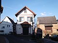
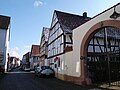
- The mostly preserved historical village center with many half-timbered houses is worth seeing.
- Impressions from Hailer
Bakehouse
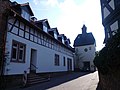
Läuthäusi

House Weber

outlook

former Saust inn (1543)

Half-timbered houses
Heylstrasse


Personalities
Born in Hailer
- Ludwig zu Sayn-Wittgenstein-Hohenstein (1831–1912), registrar and member of the Prussian mansion
Web links
- District Hailer. In: Internet presence. City of Gelnhausen
- Hailer. Local history, information. In: www.gudrun-kauck.eu. Private website
- Hailer, Main-Kinzig-Kreis. Historical local dictionary for Hessen. In: Landesgeschichtliches Informationssystem Hessen (LAGIS).
- Literature about Hailer in the Hessian Bibliography
Individual evidence
- ^ Hailer, Main-Kinzig-Kreis. Historical local dictionary for Hessen. (As of May 24, 2018). In: Landesgeschichtliches Informationssystem Hessen (LAGIS).
- ↑ Basic data of the city. In: Internet presence. City of Gelnhausen, archived from the original on January 19, 2016 ; accessed in October 2018 .
- ^ Federal Statistical Office (ed.): Historical municipality directory for the Federal Republic of Germany. Name, border and key number changes in municipalities, counties and administrative districts from May 27, 1970 to December 31, 1982 . W. Kohlhammer GmbH, Stuttgart and Mainz 1983, ISBN 3-17-003263-1 , p. 362 .
- ↑ Spessartprojekt.de accessed on February 2, 2014
