Hardtop
|
Hardtop
City of Bergisch Gladbach
Coordinates: 50 ° 58 ′ 34 ″ N , 7 ° 10 ′ 27 ″ E
|
||
|---|---|---|
|
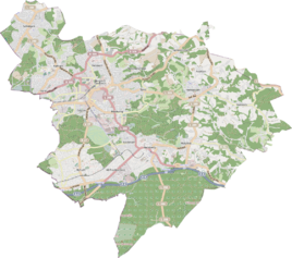
Location of Hardtknippen in Bergisch Gladbach |
||
|
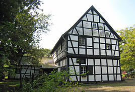
Hardt clipping 1
|
||
Hardtknippen is a district in the Herkenrath district of Bergisch Gladbach .
history
The name is derived from Hardt (= a wooded mountain slope) and Knippen (which means a small hill or ridge). The earliest reference to Hardtknippen dates from December 23, 1772 with a request for encouragement from Christian Welter to the iron stone mine "Amhart Knippen" west of the Hardt forester's house .
At that time, a small farm estate with the later name Hardtknippen must have emerged here. In 1860, 16 inhabitants were counted here together with the Hardt settlement . Several old ravines run here that led from the Milchborntal and Lückerath to Herkenrath.
monument
The half-timbered house Hardtknippen 1 is registered as monument no. 77 in the list of architectural monuments in Bergisch Gladbach .
See also
literature
- H. Jakob Schmitz: The millennial Herkenrath , Heider-Verlag, Bergisch Gladbach 1950
Individual evidence
- ↑ Herbert Stahl : Das Erbe des Erzes, Volume 3, The pits in the Paffrather Kalkmulde , Bergisch Gladbach 2006, p. 32ff., ISBN 3-932326-49-0
- ^ Andree Schulte: Bergisch Gladbach, city history in street names , Bergisch Gladbach 1995, p. 201 f. ISBN 3-9804448-0-5

