
Heidekopf (Hallenberg)
| Heather head | ||
|---|---|---|
 Heidekopf from the northeast, taken from the Sauerland-Stabil-Stuhl viewpoint |
||
| height | 704.1 m above sea level NHN | |
| location | at Hallenberg ; Hochsauerlandkreis , North Rhine-Westphalia ( Germany ) |
|
| Mountains | Rothaar Mountains | |
| Dominance | 1.96 km → northeast slope Hasselücken | |
| Notch height | 63.7 m ↓ to Gaulskopf and Wallershöhe | |
| Coordinates | 51 ° 6 '58 " N , 8 ° 35' 26" E | |
|
||
| particularities | Heidekopfturm ( AT ) | |

The Heidekopf , also called Heidkopf , near Hallenberg in the North Rhine-Westphalian Hochsauerlandkreis is 704.1 m above sea level. NHN high mountain of the Rothaargebirge . It forms the eastern foothills of the massif of 816.1 m high Ziegenhelle at the suture line to the Ostsauerländer mountainous border counted Medebacher Bay .
The Heidekopfturm observation tower stands on the wooded mountain .
geography
location
The Heidekopf is part of the eastern roof of the Rothaargebirge in the eastern part of the Sauerland-Rothaargebirge Nature Park . In the hall Wald lying his peak rises about 2.2 kilometers ( straight line ) west-northwest from the center of Halle Berger core city, and its west-northwest neighboring mountain is the dog back ( 698.4 m ).
The Eder tributary Nuhne flows north and east past the Heidekopf and south of the Nuhne tributary Weife . Not far north of the mountain peak, the Heidebach rises as a small western tributary of the Nuhne. Beyond the Weifetal and about 1.5 km south of the summit, the border with the Waldeck-Frankenberg district in northern Hesse runs .
Natural allocation
The Heidekopf belongs to the natural spatial main unit group Süderbergland (number 33), in the main unit Rothaargebirge (with Hochsauerland ) (333) and in the subunit Winterberger Hochland (333.5) to the natural area Ziegenhelle (333.51). To the south is the Wilde Struth (333.50) natural area and to the north the subunit Hohe Seite (333.7). The eastern flank falls in the main unit Ostsauerland Gebirgsrand (332) and in the subunit Medebacher Bucht (332.4) in the natural area Hallenberger Hügelland (332.41).
Mountain heights and crests
The Heidekopf is 704.1 m high. It has two peaks 90 m apart, of which the east-south-east knoll has the mountain peak; the west northwest tip is 700.2 m high. Between the two peaks there is a 695.4 m high point and 45 m east-northeast of the summit a 695.9 m high.
Protected areas
On the west and south flanks and a little north of the Heidekopf are parts of the Hallenberger Wald nature reserve ( CDDA no. 329410; designated 2001; 8.747 km² ). Most of the mountain is located in the Hallenberger Waldlandschaft protected landscape area (landscape type A) (CDDA no. 555555286; 2004; 23.2231 km²), with the LSG grassland west of Hallenberg (landscape type C) (CDDA no. 344982; 2004 ; 35 ha) adjoins. To the north and west of the mountain lies the fauna-flora-habitat area Hallenberger Wald (FFH no. 4817-301; 22.53 km²).
Heidekopfturm

Immediately northeast of the highest point of the Heidekopf is the 13 m high Heidekopfturm observation tower, built in 1972 . Its covered viewing platform offers a panoramic view of parts of the Rothaargebirge to the west and, in an easterly direction, of Hallenberg and parts of the Medebacher Bucht , over to the Kellerwald , Burgwald and Habichtswälder Bergland .
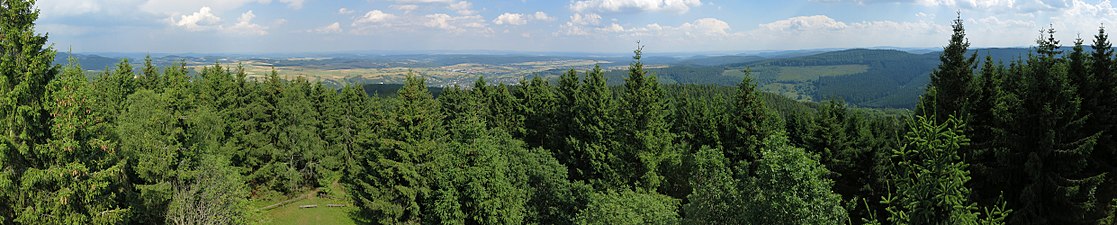
View from the observation tower from the northeast over east to south over Hallenberg and its districts to the Kellerwald and the bagpipe . The previously completely unobstructed panoramic view from the observation tower on the Heidekopf is increasingly restricted by the growing tree population.

Traffic and walking
The Heidekopf is passed in the northeast by the federal road 236 ( Züschen –Hallenberg) and in the south by the state road 717 ( Wunderthausen –Hallenberg). Because there are no public roads leading to the mountain, its summit can only be reached on forest and hiking trails, starting for example from hiker parking lots on the B 236, on the eastern flank and on the L 717. The paths leading to its summit run steeply uphill through the wooded landscape.
Web links
Individual evidence
- ↑ a b c d Topographical Information Management, Cologne District Government, Department GEObasis NRW ( information )
- ↑ a b Map services of the Federal Agency for Nature Conservation ( information )
- ↑ Martin Bürgener: Geographical Land Survey: The natural spatial units on sheet 111 Arolsen. Federal Institute for Regional Studies, Bad Godesberg 1963. → Online map (PDF; 4.1 MB)
- ↑ Heidekopfturm , in Hallenberg , on ich-geh-wandern.de