
Heiligenberg (landscape protection area)
The Heiligenberg area is a landscape protection area (LSG number 4.35.027) designated by ordinances of February 18, 1938 and December 15, 2000 by the Bodenseekreis district office as a lower nature conservation authority in the area of the Baden-Württemberg communities of Heiligenberg and Frickingen in the Lake Constance district in Germany .
location
The 202 hectare large conservation area Heiligenberg is one natural area to Linzgau . It is located south of the center of Heiligenbergss and the district road 7755 , north of the Salem district Trillenbühl and the state road 201 and northeast of the Steigen belonging to Frickingen at an altitude of up to 756 m above sea level. NN .
The municipality of Frickingen includes 14.93 hectares, which corresponds to 7.39 percent of the total area, and the municipality of Heiligenberg includes 181.50 hectares (89.85 percent) of the landscape protection area.
Protection purpose
The main protection purpose is the preservation of the landscape of the ridge from the "Alten Wachberg" via the "Schlossberg" to the "Nagelstein" with a molasses spur and cover from the Ice Age.
Attractions
Sights within the protected landscape area include the Alt-Heiligenberg Castle Rest , the Friendship Cave in Nagelfluh above the Neue Steige, Heiligenberg Castle and the Schweizerhaus.
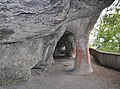
Friendship cave

historical postcard with friendship cave and castle

Heiligenberg Castle

Schweizerhaus am Schlossberg

Klause Egg below the nail stone


See also
Individual evidence
- ↑ Ordinance on the protection of parts of the landscape in Heiligenberg by the Überlingen District Office (Bodensee-Rundschau of February 26, 1938)
- ↑ http://map.kommonline-gmbh.de/heiligenberg/
Web links
- Weblink of the State Institute for the Environment, Measurements and Nature Conservation Baden-Württemberg (LUBW)
Coordinates: 47 ° 48 ′ 57.9 ″ N , 9 ° 18 ′ 44.2 ″ E


Altweiherwiese and Taldorfer Bach | Argenaue Reutenen | Lake Constance shore | Drumlin Biblis | Drumlin "Im Hasenbühl" and "Gegez" | Ice edge forms between Rebholz and Knellesberg | Ice Age rims of the Argental with Argenaue | End moraine cone Ebersberg with Mahlweiher | Terminal moraine "Height 585.1" between Gunzenweiler and Litzelmannshof | Terminal moraine wall and flat moor north of Rappertsweiler | Haldenberg | Heiligenberg | Hepbacher-Leimbacher Ried | Highest | Height 493.8 south of Tettnang near Schäferhof | Knellesberger moss | Lipbach Valley | Lippertsreuter area | Markdorfer Eisweiher | Salem Killenweiher | Sand pits or dredging pits north and west of the beer cellar | Lake district and hill country south of the Argen and Nonnenbachtal | Late Worm Ice Age terraces between Burnau, Prestenberg, Vorderreute, Buch and Krumbach | Steep edge and gravel field of the Argental south of the digester mill | Tettnang Forest with Hochwacht, Krüntenbühl, Reichenbühl, Argenhardter Kopf, Schoos and the steep edge of the Argental on the Schwandenbogen | Württemberg shore of Lake Constance - new version of the Friedrichhafen-West section | Württemberg shore of Lake Constance