Heimbach (Schwarzach)
|
Heimbach Bucher Brunnenbach |
||
|
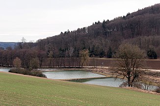
Chain of ponds on the lower reaches |
||
| Data | ||
| Water code | DE : 138434 | |
| location |
Southern Franconian Alb
|
|
| River system | Danube | |
| Drain over | Schwarzach → Altmühl → Danube → Black Sea | |
| origin | for Kraftsbuch 49 ° 2 ′ 21 ″ N , 11 ° 18 ′ 16 ″ O |
|
| Source height | approx. 502 m above sea level NHN | |
| muzzle | Below Mettendorf on the city limits to Kinding from the right and northwest into the Schwarzach coordinates: 49 ° 0 '58 " N , 11 ° 21' 47" E 49 ° 0 '58 " N , 11 ° 21' 47" E |
|
| Mouth height | 379 m above sea level NHN | |
| Height difference | approx. 123 m | |
| Bottom slope | approx. 22 ‰ | |
| length | 5.6 km | |
| Catchment area | 15.12 km² | |
The Heimbach is a stream in the area of the town of Greding in the Central Franconian district of Roth , which, after a total of less than six kilometers, flows into the Schwarzach from the right to the south-east at the town limits of Kinding .
geography
course
The Heimbach rises inconsistently on the eastern edge of Kraftsbuch. It flows through a rapidly deepening valley south-east, after about a kilometer takes up the branch of the stream from the west, which develops more consistently near the Bleimerschloß , and then continues in the soon-to-be-open floodplain east-south-east, past the dry valleys of the Brunntal from the left , the Lindener Graben from the right and the Ringeltal also from the right. After about half of its course, it crosses the parish village of Heimbach von Greding and then turns back to the south-eastern course. Shortly before the end of the valley, it passes a group of half a dozen ponds on the left bank and then turns on the last half kilometer of its run to the Grenzbach zu Markt Kinding in the Upper Bavarian district of Eichstätt . Already in the valley it crosses under the A 9 and then flows from the right into the large-scale Schwarzach , which runs roughly southwards and flows into the Altmühl only four kilometers further down in Kinding .
The Heimbach is 5.6 km long, flows out about 123 meters below its origin and thus has a mean bed gradient of about 22 ‰.
Catchment area
The Heimbach has a catchment area of 15.1 km², which in terms of natural space lies within the Franconian Alb in the Altmühlalb and in turn almost entirely in the Anlauteralb , with the exception of the small estuary in the Schwarzachtal. The greatest height on the Alb plateau, which is usually flat to the south to south-east and which is open and waterless in the western part , reaches about 549 m above sea level on the north-west corner at Schutzendorf . NHN ; above, however, is the small area around 595 m above sea level. NHN high Euerwanger Bühl in the eastern catchment area, which, like the valley slopes, is predominantly forested. The only other place in it, besides the ones already mentioned in the course, is the village of Linden near the southern edge. The catchment area is predominantly in the urban area of Greding , with the exception of a small piece of the right valley slope at the transition to the Schwarzachtal. The area is completely crossed under by the high-speed line Nuremberg – Ingolstadt – Munich in the Euerwangtunnel .
The watersheds in turn border on the catchment areas of the following neighboring waters:
- In the north and northeast, the Schwarzach itself is the closest body of water to the Heimbach estuary.
- In the south there are no major Schwarzach tributaries from the estuary to the Euerwanger Bühl beyond; from there to near the southwest corner of the catchment area, the Hafenbrunnenbach competes with the last large Schwarzach tributary, Anlauter , which only carries water far below in its valley.
- On the west side lies the catchment area of the Morsbach running south to the Anlauter .
Individual evidence
- ↑ a b c d Height requested (with right click) on: BayernAtlas of the Bavarian State Government ( information ) ( detailed map )
- ↑ a b Length and catchment area according to: List of brook and river areas in Bavaria - Lech to Naab river area, page 120 of the Bavarian State Office for the Environment, as of 2016 (PDF; 2.9 MB) (page may change.)
- ↑ catchment area. Retrieved May 12, 2018 .
- ^ Franz Tichy : Geographical Land Survey: The natural spatial units on sheet 163 Nuremberg. Federal Institute for Regional Studies, Bad Godesberg 1973. → Online map (PDF; 4.0 MB)
- ^ Dietrich-Jürgen Manske : Geographical land survey: The natural space units on sheet 164 Regensburg. Federal Institute for Regional Studies, Bad Godesberg 1981. → Online map (PDF; 4.8 MB)
