Himmelberg tunnel
|
Himmelberg tunnel Himmelberg tunnel
|
||
|---|---|---|
|
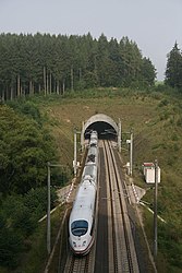
The south portal of the Himmelberg tunnel with the ICE 3 exiting
|
||
| use | Railway tunnel | |
| traffic connection | High-speed route Cologne – Rhine / Main | |
| place | Montabaur | |
| length | 2395 m | |
| Number of tubes | 1 | |
| construction | ||
| Client | Deutsche Bahn AG | |
| start of building | May 1, 1998 | |
| location | ||
|
|
||
| Coordinates | ||
| Northwest portal | 50 ° 26 ′ 41 ″ N , 7 ° 50 ′ 15 ″ E | |
| Southeast portal | 50 ° 26 '22 " N , 7 ° 52' 10" E | |
The Himmelberg Tunnel (also: Tunnel Himmelberg ) is a 2395 m long railway tunnel on the high-speed line Cologne – Rhine / Main near Montabaur .
The tunnel accommodates two slab tracks that can be driven on as planned at 300 km / h.
course
The north-west portal is located east of the Montabaur train station at route kilometers 89.9 and the south-east portal in a forest area at route kilometers 92.3.
The tunnel partially runs under areas of the local community of Heiligenroth .
The route runs in the tunnel in a continuous curve in a south-westerly direction. The gradient drops significantly. On the northwestern edge of the Nassau nature reserve located, the tube passes under near the northern West Portal, the motorway junction Montabaur the Federal Highway 3 and state road 255 and a liquid and a gas - pipeline running near the main road. Later in various follow local roads , a gas pipeline and several fish ponds. In the vicinity of the south portal, the state road 318 is driven under.
The Montabaur train station is connected to the north portal . Immediately to the south, at kilometer 92.5, is the Wahnscheidtunnel .
Two emergency exits lead south and south-west of Holy Roth, at 50 ° 26 '37 " N , 7 ° 51' 3.7" O (90.929 kilometer), and 50 ° 26 '32.7 " N , 7 ° 51' 36.9" O (Km 91.595) to the surface.
geology
In the area of the north portal there is a largely unweathered Devonian slate . In the area of the federal highway 255 follows an area of heavily weathered, decomposed tonic rock.
history
planning
At the end of 1995, the planned length of the structure was 2395 m.
construction
The tunnel was excavated with loosening blasting and tunnel excavators. The tunneling work began on May 1, 1998, starting from both portals. The tunnel sponsorship was the former member of parliament Ulla Schmidt accepted. The drive in the area of the north portal proved to be particularly difficult due to the busy trunk roads, pipelines and buildings.
The tunnel was excavated using mining techniques over a length of 2355 m. A pre-cut was made in the area of the north-west portal.
In the area of the north-west portal, the drive was preceded by exploratory drilling over a length of four meters in order to locate the transition from weakly to heavily weathered rock. At the beginning there was a multi-stage dome drive , secured with drill spikes. When the weathered mountain range was reached, about 50 meters before the B-255 crossing, a switch was made to the elm tunnel . From tunnel meter 420 the advance was switched to three-stage advance (dome, bench , bottom ). Between the tunnel meters 500 and approx. 700, a formation of heavily water-bearing layers (so-called Vallendarer gravel ) was driven under. To lower the water pressure, wells up to 80 meters deep were created from the surface to relax the groundwater .
In the southern drive, the undercutting of several fish ponds between tunnel meters 570 and 620 proved to be problematic. The ponds to be driven under when there was little cover (six to eight meters) were drained as a preventive measure and streams were laid in pipes. The rock below this area turned out to be soaked, the stability of the drive was at times endangered and was stabilized by fillings. In addition to other measures, numerous wells were also used in this area to reduce water pressure. Settlements of up to 162 mm were measured during the construction phase .
The breakthrough took place on November 23, 1999. The inner shell was manufactured from January 2000. In addition to waterproof concrete , plastic sheets were also used in sections for sealing at water pressures of up to five bar.
In June 2001 the slab track was relocated.
Installation
Before the new line was put into operation, a large-scale rescue exercise with around 1300 helpers and 300 "passengers" took place in the tunnel on June 1, 2002. It was one of five major damage exercises for the approval of the new line.
business
Another rescue exercise with 420 people took place in the tunnel at the end of October / beginning of November 2017.
Web links
- Himmelberg tunnel. In: Structurae
- Pictures of the construction of the Himmelberg tunnel as well as interior shots
Individual evidence
- ↑ a b DBProjekt GmbH Cologne – Rhein / Main, project management (ed.): New Cologne – Rhein / Main line: construction section middle section B: Selters – Brechen , brochure (20 pages), Frankfurt am Main, January 1999, p. 6
- ↑ a b c d e f Bernd Kugelmann, Franz Kapfinger: The construction of the Himmelberg tunnel . In: DB ProjektBau GmbH, Frankfurt (ed.): New Cologne – Rhine / Main line. Bridges and tunnels . without ISBN. Pp. 74-79
- ^ Deutsche Bahn AG, network division, project management for the Cologne – Rhein / Main line (publisher): route map for the new Cologne-Rhein / Main line . Map from November 1995, Frankfurt 1995
- ↑ a b At top speed through the Himmelberg tunnel . In: On the subject , ZDB -ID 2115698-0 , edition 5/2001, October 2001, pp. 9-11.
- ↑ a b c Without author: Timeline - chronology of a route . In: Eisenbahn Journal , special edition 3/2002, ISBN 3-89610-095-5 , p. 86 f.
- ↑ Rescue workers practiced on the new line . In: On the subject , ZDB -ID 2115698-0 , edition 3/2002, June 2002, p. 8.
- ↑ Klaus-Dieter Häring: Himmelberg tunnel near Montabaur: 420 rescue workers practiced the emergency in the ICE tunnel. In: nnp.de. November 1, 2017. Retrieved November 2, 2017 .


