
Logging (municipality of Alland)
|
Logging ( Rotte ) village |
|||
|---|---|---|---|
|
|||
| Basic data | |||
| Pole. District , state | Baden (BN), Lower Austria | ||
| Judicial district | to bathe | ||
| Pole. local community | Alland ( KG Raisenmarkt) | ||
| Coordinates | 48 ° 1 '25 " N , 16 ° 3' 13" E | ||
| height | 570 m above sea level A. | ||
| Residents of the village | 55 (January 1, 2020) | ||
| Building status | 21 (2001) | ||
| Statistical identification | |||
| Locality code | 03410 | ||
| Counting district / district | Maria Raisenmarkt (30601 001) | ||
| Source: STAT : index of places ; BEV : GEONAM ; NÖGIS | |||


Holzschlag is a lonely house rotte near Maria Raisenmarkt , consisting of four farms and about 15 houses on a mountain saddle. Logging is part of the market town of Alland . The village can only be reached by turning off the road from Maria Raisenmarkt to Schwarzensee . In Holzschlag, after about 3 km through the Vienna Woods , the road joins a non-passable forest path. Also because of its two inns, the place is a rest stop for hikers between Nöstach , Groisbach , Maria Raisenmarkt and Peilstein .

Panorama of felling

Schwarzenseer Hof turnoff

View from Holzschlag towards Maria Raisenmarkt and Arnsteinnadel
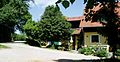
House number 3 in felling


Cadastral municipalities: Alland | Outer Kaltenbergerforst | Glassworks | Groisbach | Inner Kaltenbergerforst | Mayerling | Pöllerhof | Raisenmarkt | Rohrbach | Schwechatbach | Weißenweg | Windhaag
Localities: Alland | Glassworks | Groisbach | Felling | Maria Raisenmarkt | Mayerling | Rohrbach | Schwechatbach | Untermeierhof | Windhaag
Market place: Alland | Villages: Groisbach · Maria Raisenmarkt · Untermeierhof | Rotten: Augustinerhütte · glassworks · Greater Krottenbach · Gutental · main stream · logging · Mayerling · Linda huts · Rohrbach · Steinfeld · Windhaag · Zobelhof | Hamlet: Obermeierhof | Scattered houses: Helenental · Schwechatbach | Other locations: Iron Gate · Mayerling Carmelite Monastery · Arnstein ruins
Counting area: Alland | Maria Raisenmarkt