Homyles
| Homyles | ||||
|---|---|---|---|---|
|
||||
| Basic data | ||||
| State : |
|
|||
| Region : | Královéhradecký kraj | |||
| District : | Hradec Králové | |||
| Municipality : | Boharyně | |||
| Geographic location : | 50 ° 12 ' N , 15 ° 38' E | |||
| Height: | 240 m nm | |||
| Residents : | 152 (March 1, 2001) | |||
| Postal code : | 503 23 | |||
| License plate : | H | |||
| traffic | ||||
| Street: | Nechanice - Přelouč | |||
Homyle (German Homile , 1939–45 Homil ) is a district of the municipality Boharyně in Okres Hradec Králové in the Czech Republic . It is located 13 kilometers west of the city center of Hradec Králové .
geography
Homyle is located on the left bank of the Bystřice at the confluence of the Radostovský creek in the Východolabská tabule (table land on the eastern Elbe ). Road II / 323 runs through Homyle between Nechanice and Přelouč . To the east rises the Kozí kopec ( Geisberg , 286 m nm), in the west the Hájek ( Boharner Hagek , 269 m nm).
Neighboring towns are Kunčice and Lubno in the north, Jehlice, Mlýnek and Starý Radostov in the northeast, Nový Radostov and Těchlovice in the east, Želí and Lhota pod Libčany in the southeast, Horka, Roudnice and Puchlovice in the south, Trnava in the southwest and Boharyně in the west.
history
Homyle was created at the intersection of two trade routes that led from Königgrätz to Nový Bydžov and from Hořice to Přelouč . The first written mention of the village took place in 1403. Homyle was originally an independent estate and was later attached to Boharna . Barbara von Memmingen, b. Freiin von Waitzenau sold the goods Boharna and Homile in 1704 for 46,300 guilders to Ferdinand Bonaventura von Harrach (1637–1706), who united them with his estate Stößer .
In 1835 the village of Homile in the Königgrätzer Kreis consisted of 24 houses in which 187 people lived. In the place there was a farm and an inn. The parish was Boharna. Until the middle of the 19th century, Homile remained subject to Fideikommiss .
After the abolition of patrimonial Homile formed from 1849 a district of the municipality Bohárna in the judicial district of Nechanitz . From 1868 the village belonged to the Königgrätz district . By order of the Linguistic Commission in Prague, Homyle was established as the official place name in 1920 . 1949 Homyle was assigned to the Okres Hradec Králové-okolí; this was lifted in the course of the territorial reform of 1960, since then the village has belonged to Okres Hradec Králové. On March 3, 1991 the place had 147 inhabitants; in the 2001 census, 152 people lived in Homyle's 50 houses.
Community structure
The Homyle district is part of the Boharyně cadastral district.
Attractions
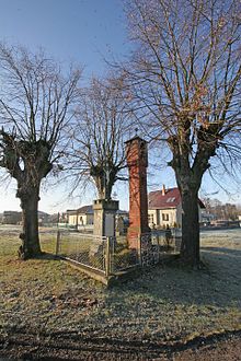
- Bell towers in clinker construction and a cross on the village square
- Memorial to the fallen of the First World War
- Bystřice natural monument, it covers the entire strongly straightened river course between Svatogothardská Lhota and Homyle
Web links
Individual evidence
- ^ Johann Gottfried Sommer , Franz Xaver Maximilian Zippe: The Kingdom of Böhmen. Statistically and topographically presented, vol. 4 Königgrätzer Kreis , Prague 1836, p. 32
- ^ Johann Gottfried Sommer , Franz Xaver Maximilian Zippe: The Kingdom of Böhmen. Statistically and topographically presented, vol. 4 Königgrätzer Kreis , Prague 1836, p. 35
- ↑ https://www.czso.cz/documents/10180/20565661/13810901.pdf/3fde2441-c81b-4a1e-9b94-551e65007f70?version=1.0


