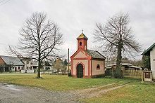
Kunčice
| Kunčice | ||||
|---|---|---|---|---|
|
||||
| Basic data | ||||
| State : |
|
|||
| Region : | Královéhradecký kraj | |||
| District : | Hradec Králové | |||
| Area : | 591 ha | |||
| Geographic location : | 50 ° 13 ' N , 15 ° 38' E | |||
| Height: | 262 m nm | |||
| Residents : | 358 (Jan. 1, 2019) | |||
| Postal code : | 503 15 | |||
| License plate : | H | |||
| traffic | ||||
| Street: | Nechanice - Dobřenice | |||
| structure | ||||
| Status: | local community | |||
| Districts: | 1 | |||
| administration | ||||
| Mayor : | Květoslav Kvasnička (as of 2008) | |||
| Address: | Kunčice 8 503 15 Nechanice |
|||
| Municipality number: | 570214 | |||
| Website : | www.kuncice.info | |||
Kunčice (German Kuntschitz ) is a municipality in the Czech Republic . It is located 14 kilometers west of the city center of Hradec Králové and belongs to the Okres Hradec Králové .
geography
Kunčice is located on the East Bohemian Table on the left bank of the Bystřice and extends along a small tributary. To the northeast rises the Jehlický vrch (302 m) and in the southeast of the Kozí kopec (286 m).
Neighboring towns are Stýskal and Nechanice in the north, Lubno and Chrást in the north-east, Hrádek in the east, Radostov in the south-east, Homyle and Boharyně in the south, Malé Babice in the south-west, Zvíkov and Budín in the west and Kobylice in the north-west.
history
Kunčice was first mentioned in a document in 1382. In the 15th century there was a wooden fortress on the Bystřice. As the owner of the fortress, which was later replaced by a stone building with a farmyard, u. a. Olfart from Kunčice, Jiří Haléř from Kunčice and Jan Gbela from Kunčice. After the village was added to the Nechanice rule under the Pecingar of Bydžín at the beginning of the 16th century , the fortress fell into desolation. In 1721 a one-story baroque palace was built on the foundation walls of the fortress. After the Thirty Years' War the Counts Schaffgotsch acquired the rule. Subsequently, from 1771 onwards, numerous nobles took over as owners. In 1832 Josef Girtel von Kleeborn sold Kunčice together with Trnava and Hrádek to the Harrach counts , who added the new property to their goods in Sadová . With that the manor in Kunčice became extinct. Around 1850, the Counts of Harrach sold the castle and the Betlach estate. After the abolition of patrimonial Kunčice formed a municipality in the Königgrätz district from 1850 . In 1905, Count Harrach acquired a gold medal-awarded pavilion at the Prague exhibition and had it moved to his zoo between Kunčice and Hrádek Castle. The pavilion was used by the Harrach for hunting events and as a resting place. After the communists came to power in 1948, the Harrach family was expropriated. In 1949 the community was reorganized as Okres Hradec Králové-okolí. The Betlachův manor and the chateau became the seat of an agricultural cooperative and fell into disrepair. The pavilion served as a residential building from 1948 to 1962. It was then used as a meteorological observatory by the Czechoslovak army and demolished in 1969. Since 1961 Kunčice belongs again to the Okres Hradec Králové. A cultural center was built in the village in 1964 and is also the seat of the municipal office. Between 1968 and 1970 an open-air swimming pool was built in the lower village on the Bystřice, which became famous for its summer discos. It was closed in 1996 and has served as a fish breeding pond ever since.
Community structure
No districts are shown for the municipality of Kunčice.
Personalities
The Schulze Petr Smetana, who held office in Kunčice in the 17th century, is the oldest known ancestor of the composer Bedřich Smetana . After a circle of artists around the poets Josef Štolba and Jaroslav Vrchlický was established in Nechanice at the end of the 19th century , they also stayed in Kunčice. The painter Antonín Chittussi created a painting of the Kunčický rybník pond.
Attractions
- Chapel on the village square
- baroque statue of St. Wenceslaus
- Memorial stone for the battle of Königgrätz
- Hrádek u Nechanic Castle , east of the village


