Vysoká nad Labem
| Vysoká nad Labem | ||||
|---|---|---|---|---|
|
||||
| Basic data | ||||
| State : |
|
|||
| Region : | Královéhradecký kraj | |||
| District : | Hradec Králové | |||
| Area : | 1532.4354 ha | |||
| Geographic location : | 50 ° 9 ' N , 15 ° 49' E | |||
| Height: | 240 m nm | |||
| Residents : | 1,660 (Jan 1, 2019) | |||
| Postal code : | 503 31 | |||
| License plate : | H | |||
| traffic | ||||
| Street: | Hradec Králové - Ráby | |||
| structure | ||||
| Status: | local community | |||
| Districts: | 1 | |||
| administration | ||||
| Mayor : | Jiří Horák (as of 2017) | |||
| Address: | Vysoká nad Labem 22 503 31 Vysoká nad Labem |
|||
| Municipality number: | 571113 | |||
| Website : | www.vysoka-nad-labem.cz | |||
Vysoká nad Labem (German Wysoka , 1939–45: Wischka on the Elbe ) is a municipality in the Czech Republic . It is located six kilometers south of the city center of Hradec Králové on the city limits and belongs to the Okres Hradec Králové .
geography
Vysoká nad Labem is located to the left of the Elbe on the western slope of the Třebechovická tabule ( Hohenbrucker Tafel ). To the northwest of the village - at the Opatowitz Elbe weir of the Březhrad hydroelectric power station - the Opatowitz Canal has its origin. In the north and east the place is surrounded by a wooded ridge. To the north rises the Podzámčí (279 m nm), in the east of the Milířský kopec ( Lhota , 285 m nm). The Nohavecký brook flows south of the village.
Neighboring towns are Na Mlýnků, Roudnická , Kluky and Nový Hradec Králové in the north, Běleč nad Orlicí , Krňovice and Štěnkov in the Northeast, Bělečko , Kukleny and Hoděšovice the east, Býšť , Hrachoviště and Borek in the southeast, Újezd u Sezemic , Zástava and Bukovina nad Labem in the south, Čeperka and Opatovice nad Labem in the southwest, Pohřebačka in the west and Březhrad in the northwest.
history
The first written mention of Vysoká took place in 1073 and 1085 in the founding deed of the Opatowitz monastery ; the village, which at that time consisted of six properties, belonged to Opatovice , Osice and Přelouč to the initial endowment of the Benedictine monastery by Vratislav II. On the Podzámčí hill in 1080 the wooden fortress Vysoká was mentioned. The Milířský kopec with piles and the charcoal burner settlement Lhotka (today Podlesí), consisting of seven chalets, belonged to a Mr. Lhota von Hradec, who left them to the monastery in 1086. Later the villages Vysoká and Lhotka grew together. The last news about the Vysoká fortress comes from 1237.
After the monastery was looted and burned down by the Hussites under Diviš Bořek von Miletínek in 1421 , the latter seized the extensive possessions. King Sigismund transferred Vysoká together with large parts of the former monastery property to Diviš Bořek in 1436, who formed the Kunburg dominion connected to the Pardubice dominion . In November 1436 imperial troops advanced on Königgrätz to subdue the preacher Ambrož Hradecký . On the night of November 7th, 1436 the Königgrätzer mercenaries attacked the night camp of the imperial and killed u. a. their commander Wilhelm Kostka von Postupitz . After the battle on Chváleňák , the imperial army was dispersed or captured. After King Sigismund had succeeded in driving Ambrož out of the city the following year, on October 14, 1437 Čert - a servant of Jan Pardus von Vratkov - together with supporters of the preacher, was overwhelmed by the Königgrätzers while trying to take the city. 23 of the attackers, including the leader Čert, were drowned at the ford across from Vysoká in the Elbe.
In 1454 a Vladikenhof with 150 bushels of fields, meadows and woods was mentioned in Vysoká . In 1464 Georg von Podiebrad acquired both parts of the Pardubitz rule. On April 5, 1465 he overwritten the rule of Pardubice including the former monastery villages Vysoká, Březhrad, Stěžery, Roudnicka and the Krivec forest to his sons Viktorin , Heinrich and Hynek von Munsterberg. In the same year, the owner of the Vysoká manor was Prokop Lišky von Vysoká, who would later become the administrator of the Pardubice manor. In 1472 the reign of Pardubitz fell to Heinrich von Münsterberg. Together with the Svítkov manor , the Vysoká manor was pledged to the Pardubice manor in 1490. In 1502 Wilhelm von Pernstein acquired the village in exchange for a part of the Kunietitz mountain from the city of Königgrätz and gave it to the Pardubice rulership . In 1513 the construction of the Opatowitz Canal began opposite Vysoká and the Opatowitz weir was built. Between 1515 and 1535 Vysoká was probably separated from the Pardubice rule, as there are no mentions either in the manorial land register or in the castle law book, possibly the village belonged to Königgrätz at this time. The Vysoká farm died out in the 16th century and was divided into parcels.
After the citizens of Königgrätz, on the initiative of Lukáš Forman, otherwise Hostovský von Hostovice on the Kopec ( Johannesberg ) near Třebeš, had built a church in memory of Jan Hus , Jerome of Prague and other Bohemian martyrs, the subjects from Vysoká and Roudnička asked John of Pernstein for it Assigned to the local parish, as they had to cross the Elbe every time to attend the masses in Opatowitz. In 1535 Johann von Pernstein concluded a settlement with the Königgrätzer citizenship and assigned the tithe and taxes from both villages previously granted to the Opatowitz church to the new church of John the Baptist on the Johannesberg. Jaroslav von Pernstein sold the Pardubice rule in 1560 to King Ferdinand I. He had the Pardubice rule reorganized through a system of 24 Rychta ( Scholtiseien ); It is not known to which Rychta Vysoká belonged at that time. In 1563 Vysoká consisted of 36 properties and was therefore significantly larger than Opatowitz. From the land register from 1588 it emerges that Vysoká belonged to Rychta Dříteč together with Rokytno , Dražkov, Bukovina , Borek , Oujezd , Bohumileč and Dříteč . The first mention of a rychta in Vysoká with responsibility for the villages Vysoká, Borek and Oujezd with a total of 60 properties took place in the land register of 1617. During the Thirty Years' War Vysoká was plundered and devastated several times, for example in 1637 by the troops of the imperial general von Hatzfeldt ; in addition, Swedish troops marched through the area in 1639, 1643 and 1645. In 1651 the Rychtář of Vysoká exercised the lower jurisdiction in Vysoká, Bukovina and Borek. At that time there was a privileged Kretscham in Vysoká; the village was still suffering from the consequences of the war, 22 of the 36 properties were in desolation. In 1785 Wysokow or Wysoka consisted of 41 houses. From 1770 the shoemaker Josef Štěrba gave private lessons in Vysoká. The first wooden schoolhouse was built in 1798.
In 1835, the village of Wysoka in Chrudim County consisted of 78 houses in which 610 people lived. There was a school and a forester's house in the village. The parish was Neu-Königgrätz . Until the middle of the 19th century, Wysoka remained subordinate to the kk cameraman Pardubice.
After the abolition of patrimonial formed Vysoká nad Labem in 1849 a municipality in the judicial district Pardubice . Emperor Franz Joseph I pledged the kk camera rule Pardubitz in 1855 as a government bond to the Oesterreichische Nationalbank , which sold the rule on June 25, 1863 to the kk privileged Österreichische Credit-Anstalt für Handel und Gewerbe. In 1865 the industrialist Johann Liebieg acquired the Wysok forest district together with the Dašice and Vysoké Chvojno estates . In 1866 Roudnička started school in Vysoká. From 1868 the community belonged to the Pardubitz district . In 1869 the old school was demolished and a new stone school building was erected in its place. In 1874 a bell tower with a frame made of beech wood was built. On November 8, 1874, the von Liebieg family organized an imperial hunt in the woods east of Vysoká in the presence of Franz Joseph I and Elisabeth of Austria-Hungary . In 1878 a farmer found a coin treasure of around 130 silver coins in the Rundel meadow . The spring flood of the Elbe in 1881 washed an early barge carved from oak onto the bank. In 1883 the Elbe bridge to Opatovice was built. Liebieg & Comp. sold the Dašice estates in 1884 for 2,700,000 guilders to Alexander Margrave Pallavicini on Jemnice . The volunteer fire brigade was founded in 1886. The Chapel of St. John the Baptist was demolished in 1887 and the parish hall was built in its place and the old war cemetery. A waterworks was also built in the same year. The Milířský Kopec was planted with 1200 fruit trees in 1888. The cemetery on the southwestern outskirts was built in 1899, before burials took place on the Johannesberg. On May 3, 1899, four people drowned below the Opatowitz canal weir in the Elbe when their boat capsized while fishing. In 1917 the village bell was requisitioned and replaced by the death bell from the cemetery. In 1922 Vysoká nad Labem was electrified. A year later, the road from Hradec Králové to Bukovina was built. The school was rebuilt in 1930. In the course of the land reform, the Pardubice district acquired the 16,068 hectare Wysok forest district in November 1931 for CZK 3,000,000. In 1940 a kindergarten opened in Vysoká, and in 1945 he moved into new premises on the ground floor of the school. Since the old waterworks did not supply enough water, a new gravitational waterworks was built in 1943 according to plans by Rudolf Kunc from Pardubice.
On the night of April 3 and 4, 1944 in the corridor ended Příseky at Vysoká from the commander Josef Šandera (alias Velký Josef ), the radio operator Josef Zizka (alias Malý Josef ), Tomáš Býček and the radio Marta existing parachutist group barium . Their task was to mobilize trade union activities in the area of Hradec Králové, Žamberk and Rychnov nad Kněžnou in order to prepare and carry out an armed uprising. The group was evacuated on January 16, 1945 in Polsko near Žamberk after betrayal by the Gestapo. On the night of May 1, 1945, the four-member family of the farmer Bohumil Kašpar was shot in their house no. 90; the murder of the married couple Kašpar and their two children was never solved. On May 7, 1945, SS men from Königgrätz surrounded the village and searched the houses; They captured seven escaped Russian prisoners of war who wanted to flee into the forest. All 47 men were herded up to the forester's house. Thereafter, the Podlesí location was shelled. Six of the captured Russians were shot on the avenue of lime trees near the forester's house, and four residents were shot for allegedly actively supporting partisans and parachutists' resistance. After a courier had delivered a message to the commander that upset the SS men, the reprisal was broken off. With the ultimatum to surrender all weapons by 11 a.m. the next day with the threat of shooting 20 residents and the mayor, the SS men drove off in a hurry and did not return to Vysoká. On May 10, 1945, the ten dead were buried. A memorial stone was set up at the forester's house on June 1, 1947.
After the collectivization of the farmers of Vysoká progressed very slowly at the beginning of the 1950s, a branch of the Czechoslovak State Assets (ČSSS) in Hradec Králové was set up in the village in September 1955. To guarantee the harvest, she first took over the farm of a farmer who had been sentenced to prison on a personal matter. In November 1955 and January 1956, as part of the judicial liquidation of kulak farms, four other farms were expropriated, which were accused of non-compliance with delivery obligations to the state as well as inadequate land management and supply of cattle. Three of the farmers were sentenced to six to eight years' imprisonment, loss of civil rights and property, and evacuation, and the fourth died while in custody. On March 6, 1956, the JZD was founded , the 34 members farmed 142 hectares. By April 1, 1956, the JZD had grown to 160 members with 567 hectares, only six farmers were working privately. On the same day the ČSSS branch was closed and its land was handed over to the JZD.
1951 Vysoká nad Labem was assigned to the Okres Hradec Králové-okolí; this was repealed in the course of the territorial reform of 1960, since then the municipality has belonged to Okres Hradec Králové. The bell tower at the school was demolished in 1951, and a roof turret for the bell was built on the roof of the syringe house. Despite protests and a collection of signatures, the school was closed for maintenance in 1982, and the entire schoolhouse has been used by the kindergarten ever since. Since 2008 the community has had a coat of arms and a banner.
Community structure
No districts are shown for the municipality of Vysoká nad Labem. Vysoká nad Labem includes the localities Malá strana, Na Vinicí, Pod Vinicí, Na Rybníku, Na Podlesí and Obicka as well as the single layers U Kříže and U Mosty ( Vischerhütte ).
Attractions
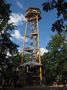
- Milíř lookout tower on Milířský Kopec, it is 31 m high and was built between 2011 and 2013. A wooden tower had stood on the site since the 1930s and collapsed in 1948.
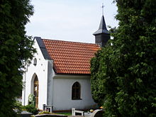
- Cemetery chapel, built in 1899 as a mortuary hall and converted into a chapel in 1993. The bell previously hung on the roof of the syringe house. In the chapel there are two memorial plaques to the parachutist group Barium and the radio transmitter Marta as well as to the murdered Kašpar family
- Opatowitz weir, the Elbe weir built during the construction of the Opatowitz Canal was replaced by a new building in 1783–1787. On the Vysok side there is the one- shift U Mosty ( Vischerhütte ), in the house the military overseer lived.
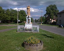
- Legionnaires' monument of freedom on the west side of the kindergarten. It was designed in 1921 by the sculptor Doležal from Pardubice for 5000 crowns and contains the names of the 32 inhabitants of Vysoká who died in the First World War. The stone consists of Horschitz sandstone and was originally set up at the forester's house as a memorial stone to the Kaiserjagd of 1874 with Franz Joseph I and Sisi. After the collapse of the Austro-Hungarian monarchy and the establishment of Czechoslovakia , the Halali memorial stone, reminding of the hated Habsburg monarchy, was removed and later converted into a war memorial on behalf of the Czechoslovak legionaries from Vysoká nad Labem.
- wooden bell tower, erected in 2010 on the site of the previous building that was demolished in 1951
- Cross opposite the school, erected in 1875
- Vysoká forester's house, visible from afar, on the hill above Podlesí, the original forester's house was in the village and was sold in 1875.
- Memorial stone for those shot dead on May 7, 1945, at the forester's house, erected in 1947
Web links
- History of Vysoká nad Labem
- Vysoká nad Labem on the website of the District Archives Hradec Králové
- Church of St. John the Baptist on St. John's Hill and cemetery chapel in Vysoká nad Labem
Individual evidence
- ↑ http://www.uir.cz/obec/571113/Vysoka-nad-Labem
- ↑ Český statistický úřad - The population of the Czech municipalities as of January 1, 2019 (PDF; 7.4 MiB)
- ↑ Jaroslaus Schaller : Topography of the Kingdom of Bohemia , Fifteenth Part: Königgrazer Kreis, Prague a. Vienna 1790 p. 150
- ^ Johann Gottfried Sommer , Franz Xaver Maximilian Zippe: The Kingdom of Böhmen. Statistically and topographically presented, vol. 5 Chrudimer Kreis , Prague 1837, p. 84
- ↑ http://www.vysoka-nad-labem.cz/paraskupina-barium
- ↑ http://www.vysoka-nad-labem.cz/druha-svetova-valka
- ↑ http://www.vysoka-nad-labem.cz/zalozeni-jzd
- ↑ http://www.vysoka-nad-labem.cz/znak-a-vlajka
- ↑ http://www.vysoka-nad-labem.cz/file.php?nid=934&oid=3552893
- ↑ http://www.vysoka-nad-labem.cz/opatovicky-splav
- ↑ http://www.vysoka-nad-labem.cz/legionari
- ↑ http://www.vysoka-nad-labem.cz/historie-obecnich-zvonu
- ↑ http://www.vysoka-nad-labem.cz/lesy


