Běleč nad Orlicí
| Běleč nad Orlicí | ||||
|---|---|---|---|---|
|
||||
| Basic data | ||||
| State : |
|
|||
| Region : | Královéhradecký kraj | |||
| District : | Hradec Králové | |||
| Area : | 1882 ha | |||
| Geographic location : | 50 ° 12 ' N , 15 ° 57' E | |||
| Height: | 240 m nm | |||
| Residents : | 349 (Jan 1, 2019) | |||
| Postal code : | 503 46 | |||
| License plate : | H | |||
| traffic | ||||
| Street: | Svinary - Krňovice | |||
| structure | ||||
| Status: | local community | |||
| Districts: | 1 | |||
| administration | ||||
| Mayor : | Dagmar Vobornikova (as of 2018) | |||
| Address: | Běleč nad Orlicí 10 503 46 Třebechovice pod Orebem |
|||
| Municipality number: | 569852 | |||
| Website : | belec.trebechovicko.cz | |||
Běleč nad Orlicí (German Großbieltsch ) is a municipality in the Czech Republic . It is located eight kilometers southeast of the city center of Hradec Králové and belongs to the Okres Hradec Králové .
geography
Běleč nad Orlicí is located on the left side of the Orlice on the edge of the Orlice Nature Park in the Orlické nivy ( Eagle meadows ). The Bělečský creek flows south of the village, from which the Bělečský náhon ditch is led through the village to Orlice below the Mlýnský rybník pond. Běleč is surrounded on three sides by extensive pine forests. To the northwest lies the Bělečský písník quarry pond, which serves as a local recreation area.
Neighboring towns are Blešno in the north, Nepasice in the Northeast, Třebechovice pod Orebem and Krňovice the east, Štěnkov and Marokánka the southeast, Bělečský Mlyn, Osada Kováků, Poděbradka, Bělečko , Podstrání and Hoděšovice in the south, Vysoká nad Labem and Nový Hradec Králové in the southwest, Malšovice and Malšova Lhota in the west and U Hájenky, Svinary , Na Žerčích and Vycházející Slunce in the north-west.
history
Finds of settlement pits bear witness to an early historical settlement. The first documentary mention was on April 9, 1336, when King John of Luxembourg established the town and the fortress Chvojno with the associated nine villages Albrechtsdorf , Běleč, Bělečko , Ekleinsdorf , Hermansdorf , Chvojence Nízké , Hoděšovice , Tiezmansdorf and Walthersdorf for 2000 shock groschen der Name is derived from the proper name Bělcův Hof ("Court of Belc"). The owners of the village changed frequently, until 1848 Běleč belonged to the Pardubice Chamberlain .
Population development
- 1558: 22 houses
- 1617: 22 houses
- After the Thirty Years War: 10 abandoned houses
- 1770: 30 houses
- 1840: 267 inhabitants
- 2004: 240 inhabitants
Community structure
No districts are shown for the municipality of Běleč nad Orlicí. Běleč nad Orlicí includes the settlements of Bělečský Mlýn and Osada Kováků, as well as the one-layer Moroccanka.
Attractions
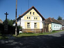
- Atonement cross (cultural monument) from the 16th century
- Protestant Reform School (1859)
- Monument to Jan Hus (1915)
- Bělečský písník local recreation area, the two smaller of the three quarry ponds form the Bělečský písník natural monument
- Mill Bělečský mlýn, the historic water mill was demolished and in the Krňovice Muzeum Skanzen implemented


