Hosenfeld (core town)
|
Hosenfeld (core town)
Municipality of Hosenfeld
|
|
|---|---|
| Coordinates: 50 ° 32 ′ 23 " N , 9 ° 29 ′ 38" E | |
| Height : | 367 (350-380) m above sea level NHN |
| Area : | 22.66 km² |
| Residents : | 1499 (December 31, 2015) |
| Population density : | 66 inhabitants / km² |
| Postal code : | 36154 |
| Area code : | 06650 |
|
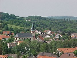
View of the center of Hosenfeld
|
|
The core town of Hosenfeld is one of the eight villages on the eastern slope of the Vogelsberg which make up today's large community of Hosenfeld in the Fulda district . The name of the new community was taken over by the previously independent community of Hosenfeld and has been the name of the larger community ever since.
Geographical location
Hosenfeld is on the western border of the district of Fulda, not far from the Vogelsberg district . The supra-regional road connections represent the of Flieden (B 40) Hauswurz coming and after Grossenlueder leading country road L3141 and the Fulda about Gieselmann , Jossa , according Bermuthshain leading country road L3079, sure. In the district springing Jossa Bach Jossa flows near Hain cell in the Lüder that comes from Bermuthshain. The topographical altitude in the local area is 375.7 m above sea level as the lowest point. The highest elevation in the district is next to the "Hohe Balz" with 384.7 the Gabberg with 387.5 m above sea level. The district of Hosenfeld covers a total area of 2,278.1458 ha and is the largest part of the community with a total area of the large community of Hosenfeld of 5,074.3521 ha.
history
The core town of the large community of Hosenfeld existed long before it was first mentioned in a document. In the early Middle Ages, probably in the 9th century, a sideline of the lords of Schlitz auf der Hainburg (formerly Blankenberg) had built Blankenwald Castle near Blankenau and acquired the property or received it as a fief . Because the Lords of Blankenwald were also on the road as robber barons in later times, the Fulda abbot Berthold II von Leipolz had Blankenwald Castle storm and razed in 1264. As a result, the Blankenau monastery came into being .
In 1279 it was first mentioned in a deed of gift as "villa Heichelle". In the said document of Simann von Blankenwald and his mother Agnes, widow of the knight Hermann von Blankenwald (Blankeinwalt), they gave a hoof in "Heichelle" at the exit of the village, which annually yielded a pound of pennies in addition to the basic interest and other minor rights and was cultivated by a certain swan (cignus), with all rights to the Blankenau monastery (Blankenowe) for your in her husband Hermann Seelenheil, as her husband had previously determined, subject to the usufruct of the son for life. After death, the proceeds from the hooves should belong to the nuns without objection on the part of the heirs to keep an annual memorial. Hosenfeld was first mentioned in a document from the Blankenau monastery from 1284.
population
Hosenfeld is the largest part of today's large community of Hosenfeld and, according to information from the community, had a total of 1,557 inhabitants on December 31, 2007, with main and secondary residences. Of these, 1,267 residents are Catholic and 168 are Protestant. 122 inhabitants belong to no or other denominations.
religion
As good as nothing can be reported about the religious and ecclesiastical life of the residents of Hosenfeld in the period before 1270, as no historical data is available or has been found to this day. When the women's monastery in Blankenau was built together with a church in 1270, the provost there also had to look after the surrounding believers, including the Catholics in Hosenfeld. At that time, Hosenfeld still belonged to the parish of Großenlüder. It only became a separate parish in 1834.
The first news about a church (chapel) in Hosenfeld can be found in reports on visitations from 1656 and 1681. From the remains of the wall found when the old chapel was demolished, local research suggests that it was built from a small fortification ( fortified church ). This is also indicated by the wall that surrounds today's church.
Web links
- Internet presence of the municipality of Hosenfeld
- Hosenfeld, district of Fulda. Historical local dictionary for Hessen. In: Landesgeschichtliches Informationssystem Hessen (LAGIS).
Individual evidence
- ↑ a b Hosenfeld, district of Fulda. Historical local dictionary for Hessen. (As of November 8, 2016). In: Landesgeschichtliches Informationssystem Hessen (LAGIS).
- ↑ Population statistics of the community of Hosenfeld , accessed in December 2016.


