Hutchinson, Minnesota
| Hutchinson | |
|---|---|
| Nickname : Hutch | |
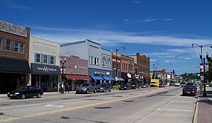
 Downtown Hutchinson |
|
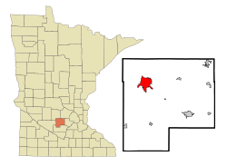
| Location in Minnesota | |
| Basic data | |
| Foundation : | 1855 |
| State : | United States |
| State : | Minnesota |
| County : | McLeod County |
| Coordinates : | 44 ° 53 ′ N , 94 ° 23 ′ W |
| Time zone : | Central ( UTC − 6 / −5 ) |
| Residents : | 14,178 (as of 2010) |
| Population density : | 636.6 inhabitants per km 2 |
| Area : | 23.36 km 2 (approx. 9 mi 2 ) of which 22.27 km 2 (approx. 9 mi 2 ) is land |
| Height : | 323 m |
| Postal code : | 55350 |
| Area code : | +1 320 |
| FIPS : | 27-30644 |
| GNIS ID : | 645316 |
| Website : | www.ci.hutchinson.mn.us |
| Mayor : | Steve Cook |
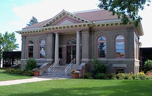
 Carnegie Library in Hutchinson |
|
Hutchinson is a city (with the status " City ") in McLeod County of south-central US -amerikanischen state of Minnesota . In 2010 , Hutchinson had 14,178 residents.
geography
Hutchinson is at 44 ° 53'20 "north latitude and 94 ° 22'30" west longitude. The city extends over 23.36 km², which is spread over 22.27 km² of land and 1.09 km² of water. Hutchinson is traversed by the southern arm of the Crow River , a right tributary of the upper Mississippi . To the west, the urban area is bounded by Campbell Lake and Otter Lake , two reservoirs that were created by the damming of the Crow River and a tributary.
Neighboring towns to Hutchinson are Cedar Mills (14.2 km northwest), Darwin (27.8 km north), Dassel (25.3 km north-northeast), Silver Lake (16.5 km east), Biscay (11.4 km southeast ) and Brownton (12 miles south).
The closest major cities are Minneapolis (98.8 km east), Minnesota's capital Saint Paul (115 km in the same direction), Rochester (230 km southeast), Sioux Falls in South Dakota (300 km southwest) and Fargo in North Dakota ( 346 km northwest).
traffic
Minnesota State Routes 7 , 15 , 22, and 25 meet in the Hutchinson metropolitan area . All other roads within Hutchinson are secondary roads or inner-city connecting roads.
With the Hutchinson Municipal Airport there is a small airfield in the south of the city area. The nearest major airport is Minneapolis-Saint Paul International Airport (101 km east).
Demographic data
| Population development | |||
|---|---|---|---|
| Census | Residents | ± in% | |
| 1880 | 580 | - | |
| 1890 | 1414 | 143.8% | |
| 1900 | 2495 | 76.4% | |
| 1910 | 2368 | -5.1% | |
| 1920 | 3379 | 42.7% | |
| 1930 | 3406 | 0.8% | |
| 1940 | 3887 | 14.1% | |
| 1950 | 4690 | 20.7% | |
| 1960 | 6207 | 32.3% | |
| 1970 | 8031 | 29.4% | |
| 1980 | 9244 | 15.1% | |
| 1990 | 11,523 | 24.7% | |
| 2000 | 13,080 | 13.5% | |
| 2010 | 14,178 | 8.4% | |
| 1880-2000 2010 | |||
According to the 2010 census , Hutchinson had 14,178 people in 5,950 households. The population density was 636.6 inhabitants per square kilometer. Statistically, 2.34 people lived in each of the 5950 households.
The racial the population was composed of 95.4 percent white, 0.9 percent African American, 0.3 percent Native American, 1.1 percent Asian, 0.1 percent Polynesian and 0.9 percent from other ethnic groups; 1.3 percent were descended from two or more races. Regardless of ethnicity, 3.8 percent of the population was Hispanic or Latino of any race.
26.6 percent of the population were under 18 years old, 57.9 percent were between 18 and 64 and 15.5 percent were 65 years or older. 51.2 percent of the population was female.
The average annual income for a household was 53,288 USD . The per capita income was $ 29,408. 8.4 percent of the population lived below the poverty line.
Sons and daughters
- John W. Foss (1933–2020), officer and general in the US Army
- John Jeremiah McRaith (1934-2017), Roman Catholic minister, Bishop of Owensboro
- Lindsay Whalen (* 1982), basketball player
Individual evidence
- ↑ a b c American Fact Finder. Retrieved March 1, 2013
- ↑ Distance information according to Google Maps. Accessed March 1, 2013
- ^ US Decennial Census. Retrieved February 28, 2013
