
Jaffa Street
| Jaffa Street Jaffa Road, Yaffo
|
|
|---|---|
|
|
|
 |
|
| Jaffa Street with important institutions and places | |
| Basic data | |
| Rechov Jafo | Jerusalem |
| District | Meshullash , Nachalat Shivʿa, Ezrat Yisra'el |
| Created | 1861 |
| Newly designed | 2004 |
| Connecting roads | Highway 1 to Tel Aviv , Sderot Weizmann |
| Cross streets | 5. Rechov Ben-Jehudah, Rechov ha-Turim, Rechov KI "aCh , Rechov Straus, Rechov ha-Melech George, Rechov Schlōmzijjōn ha-Malkah |
| Places | A) Kikkar Davidka B) Kikkar Zion C) Kikkar Zahal |
| Buildings | 7. Generali Building 4. Clal Center 8. Kikkar Safra / City Hall |
| use | |
| User groups | Pedestrian traffic , bicycle traffic , public transport |
| Technical specifications | |
| Street length | 2670 m |
The Jaffa Street ( Hebrew רְחוֹב יָפוֹ Rəchōv Jafō , German 'Jaffa Street' , Arabic شارع يافا, DMG Šāriʿ Yāfā ) is one of the longest and oldest great roads in Jerusalem , which goes back to the historic highway to Jaffa . It crosses the city from east to west, from the old city wall to downtown Jerusalem, the west portal of Jerusalem and the Jerusalem-Tel Aviv highway . The Rechov Jafo is lined with shops, businesses and restaurants. He forms with Rechov Ben-Jehudah (רְחוֹב בֶּן־יְהוּדָה ' Ben-Jehudah Street' ) and Rechov ha-Melech George (רְחוֹב הַמֶּלֶךְ ג׳וֹרְג׳ ' König Georg V- Strasse' ) the central business district Meschullasch . The most important landmarks along Jaffa Strait are Kikkar Zahal ( from east to west)כִּכַּר צָהָ"ל 'ZaHa' L-Platz ' ), Kikkar Safra (כִּכַּר סַפְרָא 'Safrāplatz' ) with town hall, Kikkar Zion (כִּכַּר צִיּוֹן 'Zijjōnplatz' ), Kikkar Davidka (כִּכַּר דָּוִידְקָה 'Dawīdqah Square' in the vernacular, but officiallyכִּכַּר הָחֵרוּת Kikkar ha-Chejrūt , German 'Freedom Square' ), the triple intersection (ha-Meschullasch) by Rechov ha-Melech George and Rechov Straus (רְחוֹב שְׁטְרָאוּס) and the pedestrian zone of the Rechov Ben-Jehudah, also the market Machaneh Jehudah and the ZOB Jerusalem . Jaffa Street has been converted into a car-free pedestrian zone, which is served by the Jerusalem light rail.
history
Originally paved as part of the Road to Jaffa in 1861 , the road quickly became the focus of expansion out of Jerusalem's Old City in the 19th century. Early neighborhoods flourished around them, such as the complex of the Russian Church Mission , Nachalat Schivʿa and Machane Jehudah, and the Schaʿarei Zedeq hospital , built by Theodor Sandel in 1897–1902 for the Kolel Holland weGermany donation fund .

The proximity to the main traffic artery quickly became the benchmark for real estate value in the booming city. Originally the traffic consisted of camels and mules, and the road was eventually improved so that horse-drawn carriages could take it. The German Templars , who founded the Jerusalem German colony , first began regular carriage service between Jerusalem and Jaffa, before the Jaffa – Jerusalem railway made the journey considerably faster and more convenient in 1892 .

During the time of the British Mandate , the street was expanded with the establishment of many central institutions such as the Old Town Hall, the city's main post office, the Anglo-Palestine Bank (1937-1939 by Erich Mendelssohn ) and the Generali office building (1934/1935 by Marcello Piacentini ) further developed. The buildings erected at their easternmost end along the old town wall were demolished in July 1944 to reveal the old town. During this time, the street took on its modern shape and became the center of the city's developing central business district as most of the trade left the old town.
During the 19-year division of the city between Israel and Jordan after the war for Israel's independence in 1948/1949 , which separated the Old City from most of modern Jerusalem, the position of Jaffa Street as the city center established itself unchallenged. Jerusalem City Council, Jerusalem Central Post Office and Machane Jehudah Market are located on Jaffa Street.
A busy thoroughfare, it has been the target of terrorist groups and has been the site of some of the most devastating terrorist attacks since the late 1960s, including the Kikkar Zion refrigerator bomb attack on July 4, 1975 that killed 15 people and injured 77 and the Suicide attack on the Pizzeria Sbarro on August 9, 2001 with 15 dead and 130 injured.
For much of its centenary, Jaffa Street served as Jerusalem's main artery. The city administration responded to the problems in the difficult inner city with targeted efforts to redesign the street, traffic on Jaffa Street is limited to public transport ( buses , taxis and trams) in order to cope with traffic jams in this area, and was The core of a new development plan to revitalize the city center.

At Kikkar Zahal , a tunnel was built under the road in 2004 to lead the city's central north-south axis through it. In order to do justice to the new system, new supply lines were laid under one side of the street , which were also expanded. To improve the road, 180 lots were cleared.
The Jerusalem light rail went into operation in 2011. At the western end of Jaffa Street, opposite the central bus station , the tram crosses the street over its own string bridge (גֶּשֶׁר הַמֵּיתָרִים Gescher ha-Mejtarīm , German 'bridge of strings' ). The bridge, designed by Santiago Calatrava 2005–2008 , is an architectural landmark of the city.
gallery
- Current pictures

Rechov Jafo, 2011
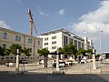
Jerusalem's New City Hall, 2019
Main Mail, 1934–1938 by Austen Harrison and Percy Harold Winter, 2009

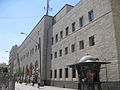
Generali building, 2019

Sansur building at Kikkar Zion, 2014

Old Town Hall, 2011

Calatrava's String Bridge, 2008
.JPG)


- Historical pictures

Barclays Bank illuminated on May 12, 1937 on the occasion of the coronation of George VI.

Hotel Fast with British and Nazi flags for the coronation of George VI.

Zion Hall with Zion Cinema 1940s

German troops pass Hotel Fast on Good Friday 1917

Visit of Wilhelm II , 1898
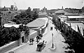
Jaffa Street after 1907


._matpc.20999.jpg)


Web links
- History of Jaffa Street on the Jerusalem City Council website ( February 5, 2012 memento on the Internet Archive )
- Eetta Prince-Gibson: Jaffa Road - It's a long and winding road ... In: jpost.com. July 27, 2009, accessed October 3, 2019 .
- Lenny Ben David: Why a Nazi Flag on a Jerusalem Hotel in the 1930s? In: israelnationalnews.com. August 31, 2015, accessed October 4, 2019 .
Coordinates: 31 ° 47 ′ 11.2 " N , 35 ° 12 ′ 36.4" E
Individual evidence
- ↑ Meir Ronnen: The life and death of Jaffa Road. In: The Jerusalem Post . October 9, 2009, accessed October 4, 2019 .