
Jerusalem old city
| Old city and city walls of Jerusalem | |
|---|---|
|
UNESCO world heritage |
|
.jpg)
|
|
| Type: | Culture |
| Criteria : | (ii) (iii) (vi) |
| Reference No .: | 148rev |
| UNESCO region : | Arabic states |
| History of enrollment | |
| Enrollment: | 1981 ( session 1st extraordinary ) |
| Red list : | since 1982 |
The Old City of Jerusalem ( Arabic البلدة القديمة al-Balda al-Qadīma ; Hebrew העיר העתיקה HaʿIr HaʿAtika ; Armenian Երուսաղեմի հին քաղաք Yerusaghemi hin k'aghak ' ) extends over an area of almost 1 km². It is defined as the area that is enclosed by the city wall of Süleymans the Magnificent from the 16th century. Outside these walls, there are two areas that historically belong to the city of Jerusalem, the Mount Zion in the southwest, where the traditions of David Grabs (Jewish) and the Upper Room (Christian) stick, and the so-called City of David to the southeast, a rocky outcrop on the Urusalim or Uruschalimum of the Middle Bronze Age or Jerusalem of the Iron Age was located. The old town, defined by the walls of Süleyman, is thus shifted a little northwards compared to earlier periods of the city's history.
history
Although ancient Jerusalem had reached its maximum extent under Herod Agrippa I and encompassed areas in the north and south that were outside the present-day old town (see: Holyland model of the city of Jerusalem ), the destruction of the city in AD 70 meant that A turning point in urban development. Only the temple area remained clearly defined by its powerful enclosing walls created under Herod .
The (not walled) re-establishment of Emperor Hadrian , Aelia Capitolina , takes up roughly the space that was later bounded by the old town walls : The civil town was in the north on the area of the Christian and Muslim quarter, the camp of the Legio Decima Fretensis in the south in the area of the Armenian and Jewish Quarter. From now on, the development of the city limits and the most important streets continued so that they can be associated with today's city map. Examples:
- Forum and Byzantine Market Place: Muristan
- Cardo Maximus : Souq Chan ez time , triple souq, Rechov Chabad
- Cardo Secundus: Tariq al-Wad
- Decumanus : Tariq Bab as-Silsila , David Street
Byzantine Jerusalem already had the current city wall in the north, west and east, but included the City of David and Zion in the south, so that a city area of about 120 hectares was created (wall of the Empress Eudokia, 443-460).
In early Islamic times, the southern border of the city was then drawn on the current line, but under the Ayyubids the Zionberg was surrounded by a wall and a tower. When Malik al-Mu'azzam had the city walls of Jerusalem pulled down in 1219, a large part of the now defenseless population emigrated. It marked a turning point in urban development when Suleyman the Magnificent had the architect Sinan Pascha build a representative wall around Jerusalem on the remains of the earlier city fortifications.
The following factors led to the growth of Jerusalem into a large city in the 19th century:
- Immigration of Jews from the Diaspora (with Jerusalem being the preferred destination for religious immigrants);
- Acquisition of large areas by Christian organizations;
- Native Palestinian population growth.
The walled old town was only a small part of this new Jerusalem, "the walls of which were directly connected to slum-like residential quarters in the north and west."
The great powers of the 19th century established a visible presence in the old city of Jerusalem. The British started with the construction of the Christ Church (1843). "Each nation wanted to shape Jerusalem in its own way and set its own architectural accents."
Hussein al-Husseini, the mayor, surrendered the city to the British Army on December 9, 1917 without a fight, so that General Edmund Allenby could move into Jerusalem on December 11. In 1920 the British League of Nations mandate for Palestine was established, which also included Jerusalem. During this time there were repeated violent clashes between Jews and Muslims. When the Israeli War of Independence broke out in 1948 , the old town was fiercely contested. It was subsequently occupied by Jordan and annexed in 1950. For the next 19 years, the old town was part of the Jordanian-controlled East Jerusalem . During this time, the old town was cordoned off to the west and the western old town gates were walled up. It fell into disrepair in the following years, especially the Jewish Quarter.
In 1967, during the Six Day War , Israeli troops conquered the Old City, and Jerusalem's city administration was expanded to include East Jerusalem and the Old City within. Since then, the city administration has renovated or rebuilt many buildings in the entire old town area. The extensions to the city wall were torn down, and a ring of parks around the old town has now largely been implemented. The housing situation in East Jerusalem is made more difficult by the fact that it is time-consuming and expensive to obtain building permits, which have to be renewed every year; as a result, building is often illegal and uncontrolled.

The Jerusalem Law of 1980 defined the entire city as a unit and "indivisible capital of Israel".
World Heritage
The old city of Jerusalem was proposed by Jordan for inclusion in the UNESCO World Heritage . At its fourth meeting in 1980, the World Heritage Committee decided to examine the proposal. After the proposal was approved by the International Council for the Preservation of Monuments , the Israeli government requested that a representative from Israel be invited to the deliberations. At the request of 17 of its 20 members, the World Heritage Committee met in Paris in September 1981 for its first extraordinary session. At the beginning of the meeting, the US delegate requested that Israel, as the state responsible for the administration of Jerusalem and with de facto control over the Old City of Jerusalem, be given the right to speak. However, this request was rejected on the grounds that a representative of Israel could not be invited to the meeting because Israel was not a state party to the World Heritage Convention. Israel only accepted the World Heritage Convention in 1999.
After the Jordanian delegate had presented the proposal at the meeting, the widespread approval of adding such an outstanding cultural asset as the Old City of Jerusalem to the World Heritage List became clear in the subsequent discussion. However, concerns were also raised as to the extent to which Jordan met the legal requirements to submit such a proposal. In a roll-call vote, it was finally decided with 14 votes in favor, one against and five abstentions to include the site in the World Heritage List as a World Heritage Site under the name Old City and City Walls of Jerusalem . The entry was made on the basis of criteria (ii), (iii) and (vi). The representatives of 9 contracting states gave declarations of approval, disagreement or abstention for the record, in which it was stressed that this decision had no implication about the affiliation of Jerusalem to a certain state.
The world heritage site is not assigned to a state, but entered separately in the world heritage list under "Jerusalem (on the proposal of Jordan)". Due to the special political situation and the unclear political status of Jerusalem, the site was placed on the Red List of World Heritage in Danger in 1982, again at the suggestion of Jordan .
The World Heritage Committee sees it as its special task to monitor and support the development of the old town and the preservation of its monuments. Most recently, in 2007, it had to intervene in the dispute over the reconstruction of a ramp that leads next to the Western Wall at the Dung Gate into the old town. This was damaged in late 2004 after heavy rainfall. The excavations carried out by the Israeli city administration to examine the building site for the repair led to sharp protests by the Arab Waqf , who claim sole authority for the administration of the old town.
The Temple Mount
-Aerial-Temple_Mount-(south_exposure).jpg)
The Temple Mount with the al-Aqsa Mosque and the Dome of the Rock dominates the old city of Jerusalem. The central shrine of Judaism was located here and is currently one of the most important shrines of Islam . After the conquest by Israeli forces in the Six Day War in 1967, the Temple Mount was handed over to the autonomous administration of the Waqf.
The Temple Mount is considered to be part of the Old City because the city wall connects to the eastern and southern retaining walls of the Temple Mount, and the Temple Mount can only be entered from within the Old City walls. It is viewed and named separately because it is uninhabited and is not assigned to any of the old town quarters.
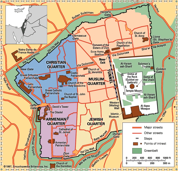
The individual quarters

The division of the inhabited old town into four quarters emerged in the 19th century, but simplified the more complex reality. This should be shown using the example of two sources from 1856:
| Barclay | Van de Velde |
|---|---|
| Jewish district (with a special residential area of the Perushim ) | Jewish quarter with three neighborhoods |
| Muslim district, divided into the residential areas of the Turks, Arabs and Maghrebians | Muslim district with seven neighborhoods |
| Christian district, divided into quarters for Armenians, Latins and Greeks | Christian district with twelve neighborhoods |
| Armenian neighborhood with three neighborhoods (according to a source from 1876, one of the neighborhoods in the neighborhood was Syrians and one was Jews) |
The boundaries between the quarters were almost everywhere markets, that is, zones where the residents of neighboring quarters met. Squares, often next to an important religious building, were central to the structure of a city district, from here the streets went out meandering in all directions, often ending in dead ends. This maze of alleyways had laid itself over the rectangular network of streets of the late antique and Byzantine city, which nevertheless remained recognizable. While European roof structures predominated in the Christian and Armenian quarters, the oriental domed roofs were mostly seen in the Jewish and Muslim quarters.
Muslim quarter
With around 30 hectares, the Muslim Quarter is the largest and also the most densely populated in the old town. It is bounded in the north and east by the city wall, in the south by the Tariq Bab as-Silsila street and in the west by the Suq Chan ez-Zeit .
Special structures:
| Surname | Construction year | Sponsorship | photo |
|---|---|---|---|
| St. Anne's Church | 12th Century | France (French General Consulate) |

|
| Co-cathedral of the Most Holy Name of Jesus | 1872 | Custody of the Holy Land |

|
| Flagellation Chapel | 1929 | Custody of the Holy Land |

|
| Condemnation Chapel | 1903 | Custody of the Holy Land |

|
| Chapel of Simon of Cyrene | 1895 | Custody of the Holy Land |
.jpg)
|
| Church of Our Lady of Sorrows | 1881 with buildings from the 12th century | Armenian Patriarchate of Jerusalem |
;_1-3000-306.jpg)
|
| Ecce Homo Basilica and Notre Dame de Sion Monastery | 1864 |

|
|
| Ecce homo bow | around 135 AD |

|
|
| Austrian hospice with the Church of the Holy Family | 1863 | Austrian Society of the Holy Land |

|
Christian quarter
With 19 hectares much smaller than the Muslim Quarter, the Christian Quarter is in the northwest of the city and is separated from the Armenian Quarter to the south by David Street. In the west of the quarter there was an area with representative European buildings since the 19th century, secondly the area around the Church of the Holy Sepulcher, which was characterized by the pilgrimage, and a purely residential area in the northeast.
Special structures:
| Surname | Construction year | Sponsorship | photo |
|---|---|---|---|
| Holy Sepulcher | oldest parts 4th century; 12th century, later modifications | Special status: Greek Patriarchate , Custody of the Holy Land , Armenian Patriarchate |

|
| Church of the Redeemer | 1893-1898 | Evangelical Jerusalem Foundation ( EKD ) |

|
| Christ Church | 1849 | Church's Ministry among Jewish People (Mission Society of the Church of England ) |

|
| Salvator Church | 1885 | Custody of the Holy Land |

|
| Annunciation Cathedral | Melkite Patriarchate of Antioch |

|
|
| Johanneskirche | 12th Century | Greek patriarchy |

|
| Muristan | around 1900 | Greek Patriarchate (as landowner) |

|
| David Citadel | 16th century with ancient structures (Tower of David) | Jerusalem Foundation |

|
| Al Yaqoubi Mosque | 12th Century | Grand Mufti of Jerusalem |

|
| Al-Khanqah-al-Salahiyya Mosque | 12th Century | Grand Mufti of Jerusalem |

|
| Omar mosque | 12th Century | Grand Mufti of Jerusalem |

|
Armenian quarter
The Armenian Quarter in the southwest of the old town is the most inconspicuous and least touristically developed area. The old Roman Cardo maximus forms the dividing line to the Jewish Quarter to the east.
Special structures:
| Surname | Construction year | Sponsorship | photo |
|---|---|---|---|
| St. James Cathedral | 12th Century | Armenian Patriarchate of Jerusalem |

|
| Church of the Holy Archangels | 12th Century | Armenian Patriarchate of Jerusalem | |
| Church of the Holy Toro | Armenian Patriarchate of Jerusalem | ||
| St. Mark's Church with St. Mark's Monastery | 12th century, rebuilt several times | Jerusalem Archbishop of the Syrian Orthodox Church |

|
| Or-haChaim Synagogue | 18th century | Ashkenazi Chief Rabbinate |

|
Jewish quarter
Most of the buildings in the Jewish Quarter were newly built after 1967. They were not intended as a restoration of the previous state, but rather as a selective reconstruction with the intention of creating a "mythical, ancient, Jewish Jerusalem". At the beginning of the 20th century, the Jewish Quarter looked architecturally similar to the Muslim Quarter, which was deliberately avoided. The reconstruction of the district was planned by a team of architects, although no one knew which residents would be drawn here: religious or secular Jews. Today the quarter is shaped by its Haredi population, so that the architectural style of the Jewish quarter is associated with the Haredim (also by them) and was adopted for the new construction of other ultra-orthodox residential areas.
Special structures:
| Surname | Construction year | Sponsorship | photo |
|---|---|---|---|
| Western Wall (haKotel) | Seven layers of stone from Herodian times |

|
|
| Hurva Synagogue | 2010, reconstruction of the synagogue from 1864 | Ashkenazi Chief Rabbinate |

|
| Ramban Synagogue | 13th century, destroyed and rebuilt several times | Ashkenazi Chief Rabbinate |

|
| Four Sephardic synagogues | 16th to 18th century | Sephardic Chief Rabbinate |

|
| Tzuf Dvash Synagogue | 19th century | Sephardic Chief Rabbinate |
Maghreb district

From the 16th century until 1948, only a corridor 22 meters long and 3 meters wide was available to the Jewish prayers at the Western Wall. Attempts by Moses Montefiore and Edmond Rothschild to provide better access through land purchases failed. On the contrary, in 1920 the League of Nations declared the area in front of the wall and the adjacent Maghreb district with its mosque to be the "holy place of Islam."
The Maghrebian quarter, also called the Moroccan quarter ( Arabic حارَة المَغارِبة, DMG Ḥārat al-Maġāriba ), was formed more than 700 years ago under the Ayyubids and Mameluks . After the capture of East Jerusalem by Israeli troops, it was torn down on the night of June 10th to 11th, 1967 to make way for today's Western Wall Plaza:
Much of this action is still unknown today; In addition to the mayor Teddy Kollek, the designated military governor of East Jerusalem, Schlomo Lahat , and the army chief, Uzi Narkiss, were responsible . They made the decision to have the Maghreb district torn down independently, without having an assignment. The only written source is a hand-drawn plan that defined the boundaries of the residential area to be demolished. In order not to associate official bodies with it, they hired 15 contractors for the demolition work, who, because of their age, had not been drafted into the military and viewed the action as a patriotic mission. You were honored in 1987 in the Knesset and received the award "Protector of the Western Wall."
With two bulldozers they demolished 135 historic houses in one night. The residents are said to have been asked by loudspeaker beforehand to gather and leave the neighborhood through the Zion Gate. But that did not happen in every case. An elderly woman, Haja Ali Taba'aki, died in bed under the rubble of her home. At 3 a.m. the space in front of the wall was free.
Several buildings on the edge of the quarter, including a mosque near the Maghrebine Gate, were initially spared and incorporated into the Jewish quarter by the Israeli government. In 1969 these buildings were also demolished.
It was not until several months after the population had been driven out and the area was destroyed, on April 14, 1968, that the Israeli finance ministry issued eviction and expropriation notices to the residents. 650 Palestinians were forcibly relocated.
The Mughrabi-Tor (German: Maghrebiner-Tor) reminds of the former quarter , which leads from the place where the Maghrebian quarter was once to the Temple Mount. It can be reached via the Mughrabi Bridge , which is the only access to the mosques on the Temple Mount for non-Muslims. In December 2011 the demolition of the wooden bridge built in 2004 and the new construction planned by the Israeli authorities were (temporarily) prevented by international protests.
The old town wall and its gates
Suleyman I had the current city wall built on Byzantine and Roman foundations between 1532 and 1542. Construction was delayed as a result of the dispute over the question of whether Mount Zion in the south should be enclosed in the wall. The city decided that the Franciscans (OFM) as administrators of the mountain would have to pay for the additional costs. Since these, as a mendicant order, did not have the necessary financial means, the Zionberg remained outside the city wall.
In the southeast the city wall is interrupted by the Temple Mount , which replaces the wall here as a natural obstacle.
The length of the city wall is 4018 m, its average height 12 m and its average width 2.5 m. It contains 34 watchtowers and eight magnificent gates. In the north these are the Damascus Gate and the Herod Gate . To the east the Lion Gate and the Golden Gate . In the south the Dung Gate and the Zion Gate , and in the west the Jaffa Gate . In 1887 the so-called New Gate was added in the north-western corner . Two former city gates were later bricked up again, the Golden Gate in the eastern city wall and the Huldah gates in the area of the southern city wall. However, as former city gates they can still be easily recognized in the city wall.
| German | Hebrew | Arabic | photo | Construction year | place |
|---|---|---|---|---|---|
| New gate |
השער החדש HaSha'ar HeChadash |
باب الجديد Bāb al-Jadid |

|
1887 | northern city wall |
| Damascus Gate |
שער שכם Sha'ar Shkhem |
باب العامود Bāb al-ʿAmūd |

|
1537 | northern city wall |
| Herodestor |
שער הפרחים Sha'ar HaPerachim |
باب الساهرة Bāb as-Sāhira |

|
unknown | northern city wall |
| Lion Gate (Stephanustor) |
שער האריות Sha'ar HaArayot |
باب الأسباط Bāb al-Asbāt / باب ستنا مريم Bab Sittna Maryam |

|
1538-1539 | eastern city wall |
| Dung gate ( dung gate ) |
שער האשפות Sha'ar HaAshpot |
باب المغاربة Bāb al-Maghāriba |

|
1538-1540 | southern city wall |
| Zion Gate |
שער ציון Sha'ar Tzion |
باب النبي داود Bāb an-Nabī Dāwud |

|
1540 | southern city wall |
| Jaffer |
שער יפו Sha'ar Yafo |
باب الخليل Bāb al-Chalīl |

|
1530-1540 | western city wall |
| Golden Gate |
שער הרחמים Sha'ar HaRahamim |
باب الرحمة Bāb ar-Rahma |

|
6th century (closed 1541) |
eastern city wall |
| Huldah gates |
שערי חולדה Shaarei Chulda |
أبواب خلدة Abwab Chulda |

|
at the time of Herod (closed around the 7th / 8th century) |
southern city wall in the area of the Temple Mount |
religious diversity
Jerusalem is considered to be the “Holy City” of three religions, Judaism, Christianity and Islam. The extraordinary religious importance of Jerusalem is based on the holy scriptures of these religions ( Tanach , New Testament and Koran ) as well as in their holy places in the old city of Jerusalem (above all Kotel , Church of the Holy Sepulcher and Temple Mount ). The old town comprises “around 255 churches and Christian sites, around 160 mosques and Muslim prayer areas, and between 80 and 110 synagogues and prayer rooms”. The old city of Jerusalem has the highest density of sacred buildings in the world .
See also
literature
- Max Küchler : Jerusalem. A handbook and study guide to the Holy City , Vandenhoeck & Ruprecht, Göttingen 2007, ISBN 978-3-525-50170-2 .
- Michael Dumpert: The politics of sacred space: the old city of Jerusalem in the Middle East conflict. Boulder, Colo .: Rienner, 2002, ISBN 1-58826-016-X [English].
- Ruth Kark, Michal Oren-Nordheim: Jerusalem and Its Environs: Quarters, Neighborhoods, Villages, 1800-1948 . jerusalem 2001. ISBN 0-8143-2909-8 .
- Simone Ricca: Reinventing Jerusalem: Israel's Reconstruction of the Jewish Quarter After 1967 . London 2007. ISBN 978-1-84511-387-2 .
- Rehav Rubin: The relief model of the city of Jerusalem by Stephan Illés (1873). In: Cartographica Helvetica. 34 (2006) pp. 35–42 full text .
- Gil Yaron : Jerusalem. A historical and political city guide . CH Beck, Munich 2007, ISBN 978-3-89331-836-0 . (Licensed edition for the Federal Agency for Civic Education , Bonn 2008)
- Johannes Becker: Locations in the Jerusalem Old City: Life stories and everyday life in a narrow urban space , transcript Verlag, Bielefeld 2017, ISBN 978-3-8376-3938-4 .
Web links
- Map of the districts (English)
- A virtual tour of the Muslim Quarter
- Old City and City Walls of Jerusalem on the UNESCO World Heritage Center website ( English and French ).
Individual evidence
- ↑ Max Küchler: Jerusalem . S. 95 .
- ↑ Max Küchler: Jerusalem . S. 96 .
- ↑ a b c d e Max Küchler: Jerusalem . S. 98 .
- ↑ Gil Yaron: Jerusalem . S. 84 .
- ↑ Gil Yaron: Jerusalem . S. 96 .
- ↑ Max Küchler: Jerusalem . S. 99 .
- ↑ Gil Yaron: Jerusalem . S. 167 .
- ↑ Decision: CONF 016 V.16. In: whc.unesco.org. UNESCO World Heritage Center, accessed April 5, 2017 .
- ^ A b First Extraordinary Session. Report of the Rapporteur, item IV. In: whc.unesco.org. UNESCO World Heritage Center, September 30, 1981, accessed May 2, 2018 .
- ↑ States Parties Ratification Status. UNESCO World Heritage Center, accessed May 2, 2018 .
- ↑ English Old City of Jerusalem and its Walls , German title according to the World Heritage List. In: Unesco.de. German UNESCO Commission, accessed on April 5, 2017 .
- ↑ a b Old City of Jerusalem and its Walls. In: whc.unesco.org. UNESCO World Heritage Center, accessed April 5, 2017 .
- ^ First Extraordinary Session. Report of the Rapporteur, annex4. In: whc.unesco.org. UNESCO World Heritage Center, September 30, 1981, accessed April 5, 2017 .
- ↑ Decision: CONF 015 X.28-35. In: whc.unesco.org. UNESCO World Heritage Center, accessed April 5, 2017 .
- ↑ Ruth Kark, Michal Oren-Nordheim: Jerusalem and its Environs . S. 49 .
- ↑ Ruth Kark, Michal Oren-Nordheim: Jerusalem and Its Environs . S. 60 .
- ↑ Ruth Kark, Michal Oren-Nordheim: Jerusalem and Its Environs . S. 64 .
- ↑ Ruth Kark, Michal Oren-Nordheim: Jerusalem and Its Environs . S. 70 .
- ↑ Ruth Kark, Michal Oren-Nordheim: Jerusalem and Its Environs . S. 59 .
- ↑ Simone Ricca: Reinventing Jerusalem . S. 6 .
- ↑ Max Küchler: Jerusalem . S. 169 .
- ^ A b c Nir Hasson: How a Small Group of Israelis Made the Western Wall Jewish Again. June 3, 2017, accessed June 4, 2018 .
-
↑ Tom Abowd: Moroccan Quarter: A History of the Present . In: Journal for Palestine Studies 7, 2000;
Nir Hasson: Rare Photograph Reveals Ancient Jerusalem Mosque Destroyed in 1967. In: Haaretz , June 15, 2012. - ↑ Gil Yaron: Jerusalem . S. 161 .
- ↑ Mughrabi Bridge open again in FAZ from December 15, 2011, page 6
- ↑ Margret Kampmeyer, Cilly Kugelmann : Introduction . In this. (Ed.): Welcome to Jerusalem (catalog for the exhibition in the Jewish Museum Berlin ). Wienand Verlag, Cologne 2017, ISBN 978-3-86832-404-4 , pp. 7–11, here p. 7.
- ↑ Alexandra Föderl-Schmid : 1 square kilometer, 255 churches . In: Süddeutsche Zeitung of December 12, 2017, p. 3.
Coordinates: 31 ° 47 ' N , 35 ° 14' E