
Jahna floodplain forests
|
Jahna Auenwälder nature reserve
|
||
| location | Seerhausen , Saxony , Germany | |
| surface | 34.24 hectares | |
| Identifier | D 01 | |
| WDPA ID | 163938 | |
| Geographical location | 51 ° 16 ' N , 13 ° 15' E | |
|
||
| Setup date | March 30, 1961 | |

The Jahna floodplain forests form a nature reserve (NSG) in the district of Meißen in Saxony . The 34.24 hectare area with NSG no. D 01 is formed from six sub-areas in the Seerhausen flood basin. The areas are covered with remains of alluvial forest and extend over a length of three kilometers to Jahnishausen .
The nature reserve was established by order no. 1 on nature reserves of the Ministry of Agriculture, Registration and Forestry (MfLEF) of March 30, 1961 (GBl.II GDR p. 166). This was changed by the resolution of the district assembly no. 69-11 / 1983 of June 23, 1983 (communications for the state organs in the Dresden district no. 3/83, p. 22). With the ordinance of the Dresden regional council of May 30, 2008 (SächsGVBl. P. 347), the protection of the area was transferred to federal German law.
description
In the area there is a regionally significant residual occurrence of black poplar ( Populus nigra ) and in the area of the alluvial forests near Jahnishausen there is a significant occurrence of March cups ( Leucojum vernum ).

Black poplar
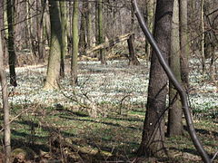
Märzenbecherwiesen near Jahnishausen


See also
Individual evidence
swell
- Protected area directory on Umwelt.sachsen.de as an Excel file
- Ordinance on the NSG


Dippelsdorf pond | Elbe islands Pillnitz and Gauernitz | Elbe valley slopes between Rottewitz and Zadel | Frauenteich Moritzburg | Gohrischheide and Elbniederterrasse Zeithain | Large wood | Jahna floodplain forests | Königsbrücker Heide | Carriage pond Moritzburg | Linz water | Whey boron ponds stag | Moor forest on the Pech River near Medingen | Neuteich | Upper Altenteich | Radener Runze | Röderauwald Zabeltitz | Seusslitzer and Gauernitzer reasons | Dry slopes southeast of Lommatzsch | Vierteich Freitelsdorf | Forest moors near Großdittmannsdorf | Winzerwiese and Gosebruch | Goat bush slopes near Oberau | Zschorna pond area