
Kärntner Strasse
| Kärntner Strasse | |
|---|---|
|
|
|
| Basic data | |
| place | Vienna Inner City |
| District | Inner city |
| Connecting roads |
Wiedner Hauptstrasse Stock-im-Eisen-Platz |
| Cross streets | Rights Wienzeile , Friedrichstrasse , Elizabeth Street , Bösendorferstraße , Opernring , Kärntnerring , Mahlerstraße, Philharmonikerstraße, Walfischgasse, Maysedergasse, Kruger Street, Führichgasse , Annagasse , Marco d'Aviano-Gasse, John Lane, Thunder Alley , Himmelpfortgasse, copper Schmiedgasse, Weihburggasse, Carinthian passage trench , Singerstrasse |
| Places | Karlsplatz , Herbert-von-Karajan-Platz, Stock-im-Eisen-Platz |
| Buildings | Vienna State Opera , Hotel Sacher , Maltese Church |
| use | |
| User groups | Pedestrian traffic , car traffic , underground line U1, tram line D, 1, 2, 62, 71, local train Vienna – Baden, bus line 2A, 59A, N49, N75 |
| Road design | partly pedestrian zone |


The Carinthian road is next to the ditch one of the most famous streets in the Vienna city center . It begins at Karlsplatz or Friedrichstrasse and leads past the Vienna State Opera straight to the center of Vienna, Stephansplatz with St. Stephen's Cathedral . There the pedestrian zone is continued in a westerly direction by the moat. In a north-easterly direction, after Stephansplatz, Rotenturmstraße connects , which leads to the Danube Canal .
history
Kärntner Strasse already existed in Vienna at the time of the Romans . In the Middle Ages it was first mentioned in a document as "Strata Carinthianorum" in 1257 and connected the city center with the Carinthian Gate of the city wall (near today's opera ). At that time, its extension was an important link to the port cities such as Venice and Trieste. There are different spellings to be found, 1563: "Cärnerstrass", 1566: "Khärnerstrass", around 1567: "Khärnnerstrassen", "Kahrnerstrass", 1587: "Kärnerstras", 1749: "Karnerstrasse".
During the founding period and in the later 19th century it was widened and often heavily rebuilt. Representative department stores such as Haas & Czizek (No. 5) or the rusk store (No. 11) emerged. The Kärntner Hof , a representative passage building built in 1878 by the architect Otto Thienemann , was demolished again in 1909/10 and replaced by the Hotel Astoria.
In 1945 the Kärntner Straße was badly damaged, which subsequently led to numerous renovations and new buildings. Due to the traditionally high economic activity here, however, there are permanent changes.
In 1974, the Kärntner Straße between the Opera and Stephansplatz was redesigned into a pedestrian zone by the architects Wilhelm Holzbauer and Wolfgang Windbrechtinger (opening: August 6, 1974), which is popular with numerous shops, such as the J. & L. Lobmeyr glass house founded in 1823 , and several cafes is lined. The Kärntner Straße, together with the Graben and the Kohlmarkt, forms the so-called “Golden U” of traditional inner-city shopping streets, which have an upscale offer and are designed as pedestrian zones. The underground line U1 runs below the street . Today the street is mainly frequented by tourists. In 2009 the pedestrian zone was redesigned, which led to controversy in advance - especially about the originally planned, modern lighting fixtures. A new accent was added in 2011 with a large department store, the Weltstadthaus .

Kärntner Strasse, early 20th century

Only existed between 1878 and 1909: The Kärntnerhof-Passage instead of today's Hotel Astoria (No. 32)
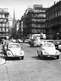
Around 1968, still without a pedestrian zone


Attractions
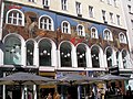
Hotel Meissl & Schadn mosaic facade, No. 16

American Bar , also known as Loos Bar known


literature
- Felix Czeike : The Kärntner Straße . (Vienna History Books Volume 16), Paul Zsolnay Verlag , Vienna 1975
- Reinhard Engel: Luxury from Vienna I . Czernin Verlag, Vienna 2001. ISBN 3-7076-0121-8
Web links
- planet-vienna.com - Kärntner Straße
- Art and culture in Vienna - Kärntner Straße in the Middle Ages
- wien.at - Pedestrian Zone City Vienna, Kärntner Straße
Individual evidence
- ^ Viennese shopping streets - Das Goldene U ( Memento from December 7, 2009 in the Internet Archive )
- ^ Kärntner Straße: A long history (ORF Vienna, February 16, 2009)
- ↑ Call for tenders for the design of the Vienna City pedestrian zone
Coordinates: 48 ° 12 ′ 17 ″ N , 16 ° 22 ′ 15 ″ E