
Köyceğiz
| Köyceğiz | ||||
|
||||
 Köyceğiz |
||||
| Basic data | ||||
|---|---|---|---|---|
| Province (il) : | Muğla | |||
| Coordinates : | 36 ° 58 ′ N , 28 ° 41 ′ E | |||
| Height : | 27 m | |||
| Residents : | 8,750 (2010) | |||
| Telephone code : | (+90) 252 | |||
| Postal code : | 4880x | |||
| License plate : | 48 | |||
| Structure and administration | ||||
| Website: | ||||
| Köyceğiz County | ||||
| Residents : | 32,817 (2010) | |||
| Surface: | 1,758 km² | |||
| Population density : | 19 inhabitants per km² | |||
| Kaymakam : | Yücel Gemici | |||
| Website (Kaymakam): | ||||


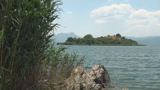
Köyceğiz is a district town and district in the Turkish province of Muğla , located on the lake.
The district is located in the middle of the province and borders Denizli in the north . The city, which lies directly on Lake Köyceğiz Gölü , has 8,750 and the district 32,817 inhabitants (as of 2010). To the south, at the end of the lake, is the ancient polis Kaunos , which is first visible from the boat through its steep rock tombs rising to the west.
History:
- The earliest name reference to the place can be found in the Geographica of Strabo : "... then Kaunos * and nearby the deep river Kalbis ......". Kaunos is also translated by Albert Forbiger in 1844 as Kaiguez or Kaigues , which is why this wording is one of the earliest names of Köycegiz. Kaiguez was also the namesake of the ancient Gulf of Glaukos, which, according to Forbiger, reached from Telmissus / Fethiye to Marmaris / Loryma and was called "Gulf of Kaiguez". John Anthony Cramer recorded the name "Keughez river" and for the region "... Sandjack of Mentesha" as early as 1832. He conducted research during the time of the Ottoman Sultan Mahmud II ( List of Sultans of the Ottoman Empire ). Thomas_Wright_ (antiquarian) wrote in 1840 "... rivers, among which are the Keughez ...". The Itineraires Ancien Paris recorded in 1845… ..sur la riviere Keughez and… .Port pres l´ile Keughez - port near the island, which emphasizes the port situation with the island. In 1862, Charles Texier mentions Keughez and the port even more specifically in “Le port communique avec petite baie de Keughez, ou nous avons mouille avec la Mesange” - the port connects with the small bay of Keughez, where we anchored with the Mesange . In 1905 Guy Le Strange reported "On the Aegean shores Mentesha was the older Caria ...".
Meanwhile, a place east of the Köycegiz Gölu was designated, today Alt Köycegiz or Eski Köycegiz . He is identified as Köycegiz through Forbiger, Cramer and Wright ( Intineraires Ancien ) and Texier. There you can find the first traces of kaigues, buildings made of medieval stone and stone, partly or largely in disrepair: mosque , minaret , stairway minaret, manor house of the Mentesche , "Mentesha", which are proven in the 14th century, Türbe , cemetery, enclosing walls , Building remains, port evidence on an island in the lake near the shore - access to the lake. A previous settlement can also be presumed as early as Byzantine times . The name Köycegiz was transferred to the newly developed place north of the lake in modern times.
In addition to the city of Köyceğiz, there are two other municipalities and 18 villages in the district.
Pictures and video
Rock graves
Link to the picture
(Please note copyrights )
Mosque
Link to the picture
(Please note copyrights )
Minaret
Link to the picture
(Please note copyrights )
Ascent minaret picture 1
Link to the picture
(please note copyrights )
Ascent minaret picture 2
Link to picture
(please note copyrights )
Türbe
Link to the picture
(Please note copyrights )
Enclosing walls
Link to the picture
(Please note copyrights )
Building remains
Link to the picture
(Please note copyrights )
Access to the lake
Link to the picture
(Please note copyrights )
-
Individual evidence
- ↑ a b Turkish Institute for Statistics , accessed on June 22, 2011
- ↑ The Lands of the Eastern Caliphate: Mesopotamia, Persia, and Central Asia by Guy LeStrange
