Fethiye
| Fethiye | ||||
|
||||

|
||||
| Basic data | ||||
|---|---|---|---|---|
| Province (il) : | Muğla | |||
| Coordinates : | 36 ° 37 ' N , 29 ° 7' E | |||
| Residents : | 91,244 (2014) | |||
| Telephone code : | (+90) 252 | |||
| Postal code : | 48 xxx | |||
| License plate : | 48 | |||
| Structure and administration (as of 2015) | ||||
| Mayor : | Behçet Saatcı ( DP ) | |||
| Website: | ||||
| Fethiye County | ||||
| Residents : | 145,643 (2014) | |||
| Surface: | 2,955 km² | |||
| Population density : | 49 inhabitants per km² | |||
| Kaymakam : | Ekrem Çalık | |||
| Website (Kaymakam): | ||||
Fethiye is a district town in the province of Muğla in southwest Turkey with 91,244 inhabitants in the core city and 145,643 inhabitants in the district (as of 2014). It is located in the southern Aegean region on the Gulf of Fethiye . Fethiye is also the name of the district (İlçe).
Surname
The city was in 1914 in honor of that year near Tiberias unfortunate first Turkish military pilot Fethi Bey in Fethiye renamed. Since 1424 it has been called Meğri or in Greek Makri , which means distant city . In antiquity her name was Telmessos , in Byzantine times from the 8th century she was called Anastasiopolis after the emperor Anastasios II.
geography
The city lies on a plain between the Gulf of Fethiye and the foot of the Mendos Dağı, a branch of the southwestern Taurus (Turkish: Batı Toroslar). The port and old town are protected from the open sea behind the Oyuktepe peninsula and Şövalye Adası (Knight's Island ), the southernmost of a chain of twelve islands. From the western bay of Karagözler, at the transition to Oyuktepe, the plain stretches in a wedge shape about 25 kilometers in a northerly and easterly direction. In the north the Boncuk massif (Boncuk Dağları) rises up to 2418 meters. The Babadağ promontory (1969 meters) stretches south to the valley of Eşen Çayı . The highest point in the surrounding area is the Uyluk Tepe at 3,024 meters, about 45 kilometers east of the city.
history
On the basis of philological research, it is assumed that the place on the sheltered bay dates back to the 3rd millennium BC. Was inhabited. However, there is no proof of this. The city was first mentioned under the name Telmessos in the 5th century BC. BC as a member of the Attic-Delian League . From the 4th century BC It was under Lycian rule. Telmessos, together with the today's ruined city of Kadyanda, about 18 kilometers north in the mountains near Üzümlü , formed the western border of the ancient Lycian city union .
During the campaign of Alexander the Great , his general Nearchus took the city in 334 BC. A. After Alexander's death, it fell under the rule of the Ptolemies . With the defeat of Antiochus III. in the Syrian-Roman war Telmessus was 190 BC Part of the Kingdom of Pergamon , 137 BC. It fell to Rome .
In the 8th century, the now was Byzantine city in honor of Emperor Anastasios II. In Anastasiopolis renamed.
In 1284 the Menteşe Beyliği conquered the city. In 1424 it fell under Ottoman rule , by which it was given the name Meğri , meaning distant city . But the Johanniter , who had their seat on Rhodes from 1310 to 1530, also claimed the city several times. They built a crusader castle on the Acropolis , the ruins of which are still visible from afar, and used the offshore island of Şövalye Adası as a base for their crusader fleet . The name is derived from the French word chevalier (knight).
After the First World War , Fethiye was under Italian occupation between May 11, 1919 and June 20, 1920. In 1924 the Greek inhabitants, who until then made up the largest part of the population, had to leave the city as part of the international exchange through the Treaty of Lausanne , as did the Greeks in neighboring Kayaköy . They settled in Greece, especially in the town of Nea Makri in Eaststatica .
A major 7.1 magnitude earthquake devastated most of the city on April 25, 1957, killing sixteen people and injuring nearly a hundred. In 1856 the city was hit by a strong earthquake. In August 2004 and June 2012 there were also notable earthquakes, with some injuries and damage.
economy
The city is an important shopping and supply center for the residents of the surrounding area, as well as a large marketplace where farmers in particular offer their products from the fertile surroundings. There are some industrial parks and hundreds of small workshops, but hardly any industry. In the western part of the port, on the bay of Karagözler, there are still some shipyards .
The main industry is tourism. Most of the hotel complexes and the city's longest beach, at five kilometers, are located in the northern suburb of Çalış. The port is also dedicated to tourism, with hundreds of excursion boats offering tours to the surrounding islands and bays. The bay of Ölüdeniz and its turquoise-blue lagoon is a tourist attraction 14 kilometers outside the city .
traffic
From the central bus station (Otogar) there are 24-hour bus connections to most of the country's major cities (including Istanbul , Ankara , Izmir and Antalya ). Dalaman International Airport is approximately 50 kilometers away. During the season (March to October) there is a ferry to the Greek island of Rhodes . In addition to the small commercial harbor, there is a marina that globetrotters like to use for the winter, as well as several diving centers.
Attractions

- The old Turkish and partly still ancient city center was largely destroyed in the earthquake in 1957. The reconstruction was done in an expedient style. To the east of the port is the bazaar district, with numerous restaurants, bars and shops, largely geared towards tourism.
- The traditional Eski Hamam from the 16th century has been preserved in the old town .
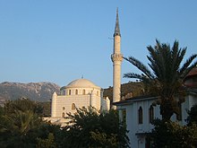
- The old Eski Cami mosque , which Cezayirli Hasan Paşa had built in 1791, has also been preserved .
- The main attractions are the rock tombs , which were carved into the rock walls above the city center in the Lycian period. In addition to simple chamber graves, there are also entrances in the design of temple facades. The tomb of Amyntas from the 4th century BC is most pronounced . Chr.
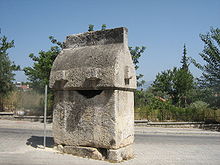
- Scattered across the city are a few Lycian and Roman-Lycian gable sarcophagi in situ. They stand on paths, squares, in a residential area also in the middle of a street; others are built into the walls of buildings.
- Also on the rocks above the city, on an acropolis plateau, are the ruins of the Johanniter castle built in the 15th century by knights of the Rhodian Order of St. John with the support of the Genoese . In some cases it is easy to see that the remains of a much older building have been included.
- Also worth seeing are the ruins of the Hellenistic theater, which was uncovered and described by the French scholar Charles Texier in the mid-19th century . The system without a stage corresponds to an early building type. In an earthquake in 1856, however, extensive destruction and spills occurred. In the second half of the 1990s, it was uncovered again by archaeologists from Istanbul University .
- The city has a small archaeological museum, built in 1962. The most interesting exhibit is the Letoon trilingual , a stele with a trilingual inscription in Aramaic, Lycian and Hittite script.
Others
Fethiyespor is the city's football club founded in 1933. The players are often referred to by their fans as Akdeniz'in Şimşekleri (German: The lightning bolts from the Mediterranean) or Apaçiler (German: The Apaches ).
sons and daughters of the town
- Yunus Nadi Abalıoğlu (1879–1945) (* 1985), Turkish journalist and founder of the daily Cumhuriyet
- Ersin Akdeniz (* 1987), Turkish soccer goalkeeper
- Ali Özek (* 1932), Turkish Islamic theologian and university professor
- Selçuk Özkan (* 1985), Turkish football player
- Ülker Radziwill (* 1966), German politician
Individual evidence
- ↑ citypopulation turkey, mugla , accessed January 16, 2016
- ^ Webcitation.org , accessed January 16, 2016
- ^ Fethiye Museum , accessed January 16, 2016
- ^ Michael Bussmann, Gabriele Tröger: Turkey - Lycian coast. Antalya to Dalyan , Michael Müller Verlag, Erlangen 2014, ISBN 978-3-89953-860-1 , p. 179
- ↑ Max R. Kaufmann: When the earth trembles in Turkey ; in: [www.dtgbonn.de/Archiv/Mitteilungen/M016/Mitteilungen_016.pdf German-Turkish Society eV Bonn, Mitteilungen, June 1957, issue 16], accessed on January 16, 2016
- ↑ Handelsblatt dated August 4, 2004 , accessed on January 17, 2016
- ^ Die Welt from June 12, 2012 , accessed on January 17, 2016
- ↑ Old Turkish Bath


