Kahun (Kaski)
| Kahun काहुँ |
||
|---|---|---|
|
|
||
| Coordinates | 28 ° 14 ′ N , 84 ° 0 ′ E | |
| Basic data | ||
| Country | Nepal | |
| Gandaki | ||
| Zone | Gandaki | |
| ISO 3166-2 | NP-P4 | |
| District | Kaski | |
| height | 1100 m | |
| Residents | 2378 (2011) | |
|
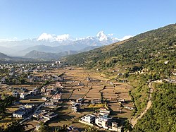
Kahun, on the right in the picture above the Pokhara plain
|
||
Kahun ( Nepali काहुँ ) is a former Village Development Committee (VDC) in the Kaski district of the Gandaki administrative zone in central Nepal .
Kahun was incorporated into the neighboring city of Pokhara in 2014 . Kahun forms a rural area on an up to 1400 m high southern foothills of the Annapurna Himal . The VDC is east of the city of Pokhara.
Residents
The VDC Kahun had 2378 inhabitants (1119 of them male) in 574 households at the 2011 census.
Web links
Commons : Kahun - collection of images, videos and audio files
Individual evidence
- ↑ National Population and Housing Census 2011 (PDF) Central Bureau of Statistics. Archived from the original on July 31, 2013.


